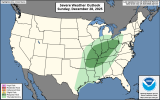
Looks like some severe potential might get as far north as about the I-80 corridor in Illinois. Too bad I have to work (switched days due to being down a staff member who would normally fill the weekend position...as usual).
One thing that strikes me is the northern portion of the cold front isn't moving that fast. Along the MS River at 21Z and not quite to Chicago by 00Z Monday. Could mean forcing up here is more favorable for a discrete mode.
Yet again, lack of moisture isn't what's limiting the instability. It's bad lapse rates.
View attachment 49292