• Welcome to TalkWeather!
    We see you lurking around TalkWeather! Take the extra step and join us today to view attachments, see less ads and maybe even join the discussion.
    CLICK TO JOIN TALKWEATHER

Severe Weather 2025

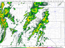
suddenly a tornado warning again...
In Hawaii, of all places.
297
WFHW50 PHFO 191638
TORHFO
HIC007-191700-
/O.NEW.PHFO.TO.W.0001.251219T1638Z-251219T1700Z/

BULLETIN - EAS ACTIVATION REQUESTED
Tornado Warning
National Weather Service Honolulu HI
638 AM HST Fri Dec 19 2025

The National Weather Service in Honolulu has issued a

* Tornado Warning for...
Niihau in Kauai County in Hawaii...

* Until 700 AM HST.

* At 637 AM HST, a severe thunderstorm capable of producing a tornado
was located 36 miles southwest of Barking Sands, moving northeast
at 15 mph.

HAZARD...Tornado.

SOURCE...Radar indicated rotation.

IMPACT...Flying debris will be dangerous to those caught without
shelter. Damage to roofs, windows, and vehicles will
occur. Tree damage is likely.

* This tornadic thunderstorm will remain over sparsely populated
areas of Niihau in Kauai County.

PRECAUTIONARY/PREPAREDNESS ACTIONS...

TAKE COVER NOW! Move to a basement or an interior room on the lowest
floor of a sturdy building. Avoid windows. If you are outdoors or in
a vehicle, move to the closest substantial shelter and protect
yourself from flying debris.

&&

LAT...LON 2188 16023 2192 16019 2197 16012 2190 16008
2188 16011 2187 16016 2178 16021 2181 16025
TIME...MOT...LOC 1637Z 238DEG 14KT 2182 16029

TORNADO...RADAR INDICATED
MAX HAIL SIZE...<.75 IN

$$

SP
 
That little surprise tornado warning was in a bit of a rough environment but I can see why it rotated. Nice low level thermodynamics, managed to form as a discrete mode and not a junky mess which is to the west of it. There are more discrete cells forming off shore, curious if a waterspout fest like earlier this year is on route
 
we need a fire weather thread
We do have one, it was just never picked up. Not sure how to link individual threads, but it's named "2025 wildfires".
 
The SPC has outlined a D3 Marginal for the western California coast, mentioning "weakly rotating storms" indicating there likely will be a brief tornado risk with onshore squalls. The NAM has a actually alright environment given it's California in December. 225 0-1km SRH and 700 MLCAPE. A few brief tornadoes would easily be possible with convection. I wouldn't expect the mode to be poor, it could feature a few low topped, semi discrete cells coming onshore. Lapsw rates also are steep, with low level instability around 180 (NAM maybe overdoing). Regardless, this is a interesting risk and i certainly would expect a sneaky onshore Christmas Day tornado risk.
 
Temperature output on today's model runs for Tupelo and Aberdeen. Severe weather threat incoming late month (December 28th or so). Definitely so if the Canadian verifies.

Most recent late December (December 28th) severe weather outbreak was 2024. Otherwise, you have to go all the way back to 2010 to find the last severe weather threat in late December (December 31st).

The current Day 3 Marginal Risk in California says we need to look out farther east.
 

Attachments

  • gfs-deterministic-KTUP-daily_tmin_tmax-6426400.png
    gfs-deterministic-KTUP-daily_tmin_tmax-6426400.png
    26.4 KB · Views: 0
  • gfs-deterministic-KM40-daily_tmin_tmax-6426400.png
    gfs-deterministic-KM40-daily_tmin_tmax-6426400.png
    26.6 KB · Views: 0
  • ecmwf-deterministic-KTUP-daily_tmin_tmax-6404800.png
    ecmwf-deterministic-KTUP-daily_tmin_tmax-6404800.png
    27.3 KB · Views: 0
  • ecmwf-deterministic-KM40-daily_tmin_tmax-6404800.png
    ecmwf-deterministic-KM40-daily_tmin_tmax-6404800.png
    27.3 KB · Views: 0
  • gem-all-KTUP-daily_tmin_tmax-6404800.png
    gem-all-KTUP-daily_tmin_tmax-6404800.png
    23.8 KB · Views: 0
  • gem-all-KM40-daily_tmin_tmax-6404800.png
    gem-all-KM40-daily_tmin_tmax-6404800.png
    23.8 KB · Views: 0
18z HRRR said a saturated yet broken line of mini supercells for W Cali. Personally think a 5% may be warranted as models seem to agree on this orientation. Very strong low level shear profiles and enough instability will be avaliable to support this. Few tornadoes certainly possible.
 

Attachments

  • HRRRSW_prec_radar_040.png
    HRRRSW_prec_radar_040.png
    164.8 KB · Views: 0
First tornado warning for Los Angeles County since August 21st, 2004
 
Back
Top