Late response, but
1: 6/20 - Do I have to explain? Historical night and i can't believe i watched a EF5 happen..
2: 3/14 + 3/15 - Just as impressive as it gets, a nocturnal string of pearls dealing in 600+ SRH, the environment on 3/14 was truly upper echelon and really, the only limiting factor to more was the time of year. Had that same setup took place in April, with more instability likely built up, i just couldn't imagine. It practically tested the limits of what was possible in March. Had the southern mode got organized, the night would've been even more chaotic additionally. 3/15 verified, and the fact we still managed many significant tornadoes in Alabama proves how much worse it could've been.
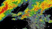
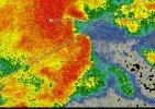
3: 5/16 - This is the 2nd outbreak that i came home from school on, took a nap after glancing over the models, and woke up and then proceeded to witness a major outbreak. This happened also on 4/26/24, which i remember extremely well, and i find it a strange coincidence in some sort of way. I woke up after the St Louis EF3 took place, and initially, there was a bit of a lull. Some inversion limited the supercells. We did have the SE MO EF3 during then, but then it took a good hour for things to ramp up. I was convinced a dangerous evening was still ahead and storms were just getting ready. Suddenly, a large tornado touches down on the warm front near Linton, IN. The rest is chaos. A TORE rapidly develops near Marion, IL, a intense tornado develops near Morganfield. A TBSS spike in the Bloomington area, and then suddenly, it reverted to calm. I pretty much tried to find as much as i could of the aftermath of those tornadoes hours after, and during then, it was probably.... 3am in Ireland. I continue watching radar but nothings happened since.. A suspicious signal with a tight couplet develops near Nancy, KY. From there, many of us proceeded to watch the deadliest tornado of the year take place as it swept thru Somerset + London, KY maintaining EF2+ intensity all thru its path, peaking at EF4 in London. The feeling for me was a loud and eerie silence, just watching that large debris ball approach town. Absurd outbreak.
4: 5/18 - A volatile setup that turned out to be the most classic significant outbreak the Plains have had in years. For chasers, most of it occurred after dark, but the Arnett, OK + Grinnell, KS tornadoes were the daytime spotlights. Both were likely violent but stood at EF3. I was a bit shocked seeing how bad it was in Grinnell. A few members here seen Arnett happen too - that would be
@CheeselandSkies and
@andyhb. I did not think i would end up witnessing a 5/4/07 repeat in terms of the area take place soon that night..
5: Melissa - The potential was there, and I'm pretty sure many knew it but even Melissa exceeded expectations becoming one of the most powerful Atlantic hurricanes in history. The damage is truly high end, and it's safe to say we're not gonna see a storm like Melissa for quite some bit.
2025 is a truly insane year by all means, and there's a reason i say "is". Who knows if there's one last event waiting for us this December? Hopefully not. I think we've had more than enough destruction this year, and hope all affected by tornadoes/hurricanes are having a great recovery. Rest in peace to all those deceased in tornadoes/hurricanes this year, too. Hopefully, 2026 has none of this..