
Navigation
Install the app
How to install the app on iOS
Follow along with the video below to see how to install our site as a web app on your home screen.
Note: This feature may not be available in some browsers.
More options
-
Welcome to TalkWeather! We see you lurking around TalkWeather! Take the extra step and join us today to view attachments, see less ads and maybe even join the discussion. CLICK TO JOIN TALKWEATHER
You are using an out of date browser. It may not display this or other websites correctly.
You should upgrade or use an alternative browser.
You should upgrade or use an alternative browser.
Severe Weather 2025
- Thread starter KevinH
- Start date

AJS
Member
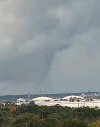
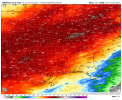
Yeah, it’s 100% on the ground. Can’t believe this is happening to be honest. Not looking forward to round 2 earlier which is supposed to be even more wild.Radar-confirmed, and spotted OTG by chasers.
View attachment 48881
WeathermanLeprechaun
Member
Kds86z
Member
Kds86z
Member
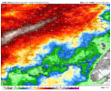
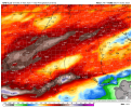
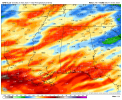
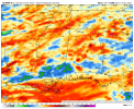
Sounding from vicinity of Ashland/Alexander City tomorrow at 18Z. Lots of 3CAPE and a nicely-curved hodograph. Considering the parent system is already pulling away to the north at this point, those are impressive SRH values. Have a feeling it could be a sneaky day tomorrow in Alabama and parts of Georgia. Hard to justify a 10% though, but is one of those setups where that could verify if it reaches its potential. We may have just enough LLLR-CAPE overlap to support more vigorous activity along the AL/GA border tomorrow, depending on how things progress.18z hrrr is impressive for the warm sector in central Alabama tommorow. I think the 5% is good though unless there's some mesoscale stuff tommrow that increases the risk


Kds86z
Member
CheeselandSkies
Member
Check out this frame I grabbed of the hook echo at just 50' AGL from the Houston Intercontinental TDWR!

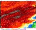
I think any 10% risk we see will heavily depend on the morning system and how it finishes. Maybe enough of a gradient or something to create a focal point somewhere in central Alabama for more intense convection.Sounding from vicinity of Ashland/Alexander City tomorrow at 18Z. Lots of 3CAPE and a nicely-curved hodograph. Considering the parent system is already pulling away to the north at this point, those are impressive SRH values. Have a feeling it could be a sneaky day tomorrow in Alabama and parts of Georgia. Hard to justify a 10% though, but is one of those setups where that could verify if it reaches its potential. We may have just enough LLLR-CAPE overlap to support more vigorous activity along the AL/GA border tomorrow, depending on how things progress.
View attachment 48883View attachment 48884
Kds86z
Member
WeathermanLeprechaun
Member
Just hasn't been my day in terms of trying to forecast this event we'll but it would appear a conditional strong tornado or two will continue in SE TX along the confluence band as of latest models
- Moderator
- #7,672
Since this system already seems to be overperforming, I thought I would go ahead. Give me a bit to move things.
https://talkweather.com/threads/severe-weather-threat-november-24-25-2025.2467/
https://talkweather.com/threads/severe-weather-threat-november-24-25-2025.2467/
Kds86z
Member

WeathermanLeprechaun
Member
Tornadic circulations may persist past 06z with isolated prefrontals STILL possible in NE LA/W MS with a embedded tor threat on the line. The timing is more late then expected, being honest. This tornado threat may last all night...

We have a thread for today's and tomorrow's event
")
Latest GFS, Canadian, Euro, NBM thru 240 hours and ICON thru 180 hours. Euro is currently the outlier as far as total rainfall.
Attachments
-
 icon-all-alms-total_precip_inch-4676800.png164.8 KB · Views: 0
 -
 gfs-deterministic-alms-total_precip_inch-4892800.png 00z.png155.7 KB · Views: 0
 -
 gfs-deterministic-alms-total_precip_inch-4914400.png 6z.png158.7 KB · Views: 0
 -
 gem-all-alms-total_precip_inch-4892800.png 00z.png149.9 KB · Views: 0
 -
 gdps-all-alms-total_precip_inch-4892800.png 00z.png153.6 KB · Views: 0
 -
 nbm-conus-alms-total_precip_inch-4936000.png158.7 KB · Views: 0
 -
 nbm-para-alms-total_precip_inch-4936000.png155.3 KB · Views: 0
 -
 ecmwf-deterministic-alms-total_precip_inch-4892800.png182.5 KB · Views: 0
Grand Poo Bah
Member
Is there a place to discuss snowstorms/blizzards? Would a dedicated thread be worth starting? Looks like it's going to be a very active year in that regard.
- Moderator
- #7,678
Is there a place to discuss snowstorms/blizzards? Would a dedicated thread be worth starting? Looks like it's going to be a very active year in that regard.
There's a thread for winter weather discussion - https://talkweather.com/threads/winter-weather-season-2025-26.2446/
Grand Poo Bah
Member
Thank you!There's a thread for winter weather discussion - https://talkweather.com/threads/winter-weather-season-2025-26.2446/


