• Welcome to TalkWeather!
    We see you lurking around TalkWeather! Take the extra step and join us today to view attachments, see less ads and maybe even join the discussion.
    CLICK TO JOIN TALKWEATHER

Enhanced Fujita Ratings Debate Thread

Hurricane Melissa currently has wind gusts exceeding 215 mph. Praying for everyone currently in the path. It's going to be devestating.

If it makes landfall at this strength who thinks the wind damage will resemble an EF5 tornado? Will entire forests be flattened and debarked? Cars and trains tossed? Ground scouring/trenching? There will certainly be a vertical wind component in the mountains too.
Now that we have witnessed the extensive and staggering devastation caused by Hurricane Melissa, to be honest, for such an intense hurricane, the peak wind gusts in many coastal and mountainous areas were likely far beyond 215 mph, possibly much higher. Dropsondes even recorded a wind speed of 252 mph at an altitude of 250 meters. Considering the low sampling rate of dropsondes, the probability of capturing the absolute peak gust is negligible. In the cases of Michael and Dorian, some still argue that very few areas actually experienced wind gusts exceeding 200 mph. Now, with an even stronger hurricane making landfall at peak intensity (likely 165+ knots), and with 200m+ mountains located near the landfall site well within the boundary layer, I simply see no justification for continuing to debate whether these areas experienced EF5-level gusts.

Yet, we did not observe EF5-level structural damage. In my opinion, the strongest destruction I’ve seen from this hurricane roughly falls within the high-end EF3 to low-end EF4 range, a result that was entirely expected. In reality, you’ll find that wind damage from 140-kt and 170-kt tropical cyclones is often difficult to distinguish in the field.

While hurricanes and tornadoes are fundamentally different, this once again highlights the shortcomings of relying solely on wind speed to gauge tornado intensity. From a vortex dynamics perspective, hurricanes generally have a very large swirl ratio, making it reasonable to apply the same wind speed standards uniformly.

However, in reality, some tornadoes can also have a very large swirl similar to hurricanes like Mulhall tornado 1999, while others can be extremely small like most rope type tornados. Additionally, tornadoes exhibit a much wider variability in diameter and translational speed compared to hurricanes, all of which add complexity to intensity assessment.

Currently, we cannot obtain precise wind speed measurements for every tornado. But if we could, we would quickly realize that relying purely on wind speed to determine intensity poses significant problems. In fact, mobile Doppler radar observations have already demonstrated this issue.
 
Last edited:
Again, while I don’t trust every single claim posted on Tornado Talk (especially some of the Smithville stuff), gathering detailed publicly available information and developing a reasonably clear idea of a tornado’s intensity based on that information is not something experts are only privy to. Like I said earlier, it’s not this insanely convoluted process of analysis that only a select few can objectively understand. There’s healthy skepticism, and then there’s being unreasonably dismissive of anything that isn’t backed by the NWS.

The facts are that the MEG survey of New Wren tornado missed miles of damage path, and that missed segment contained incredibly intense EF5 candidate damage. That isn’t really up for debate.
You could make an argument that based on what they found, New Wren really wasn’t far behind some of the EF5s from that day.
 
There’s healthy skepticism, and then there’s being unreasonably dismissive of anything that isn’t backed by the NWS.
I never said I was dismissive of anything not backed by the NWS. My issue with TornadoTalk specifically is that they have a history of using objectively non-reliable sources in their papers, and sometimes don’t even cite their sources at all. Match that with the things above (including the paywall), and I just have a hard time taking them seriously.

Are there any particularly intense damage photos from New Wren? I haven't seen much but I also haven't looked deep.
 
Last edited:
Well, here it is. I'm planning on making a series of posts explaining the tornadoes that I would have rated differently, but this is my first draft of my list of violent tornadoes during the EF5 drought, between May 21, 2013 and June 20, 2025 (and I also found a lot of EF2s which I think should have been rated EF3). I'm open to feedback, and in fact I'd really like to hear people's opinions on the tornadoes that I'm still undecided on in particular, but feedback on any of them would be much appreciated. Obviously subject to change.

Italicized = I'm still undecided on what rating I would give the tornado.
Asterisk = I consider it to be a very marginal/low-end violent tornado.

List:

El Reno, Oklahoma - May 31, 2013 (EF4)
Belmond, Iowa - June 12, 2013 (EF4)*
Wayne, Nebraska - October 4, 2013 (EF4)
Pierson, Iowa - October 4, 2013 (EF4)*
Washington, Illinois - November 17, 2013 (EF4)
New Minden, Illinois - November 17, 2013 (EF4)

Vilonia, Arkansas - April 27, 2014 (EF5)
Tupelo, Mississippi - April 28, 2014 (EF4)
Louisville, Mississippi - April 28, 2014 (EF4)
Stanton, Nebraska - June 16, 2014 (EF5)
Pilger, Nebraska - June 16, 2014 (EF4)
E Pilger, Nebraska - June 16, 2014 (EF4)
Wakefield, Nebraska - June 16, 2014 (EF4)
Coleridge, Nebraska - June 17, 2014 (EF4)
Alpena, South Dakota - June 18, 2014 (EF4)
Columbia, Mississippi - December 23, 2014 (EF4)

Rochelle, Illinois - April 9, 2015 (EF5)
Cisco, Texas - May 9, 2015 (EF4)
Coal City, Illinois - June 22, 2015 (EF3 or EF4)
Clarksdale, Mississippi - December 23, 2015 (EF4)
Holly Springs, Mississippi - December 23, 2015 (EF4 or EF5)
Rowlett, Texas - December 26, 2015 (EF4)

Katie, Oklahoma - May 9, 2016 (EF4)
Sulphur, Oklahoma - May 9, 2016 (EF3 or EF4) (Possible EF4 based on vehicle damage.)
Connerville, Oklahoma - May 9, 2016 (EF3 or EF4) (Same as Sulphur.)

Chapman, Kansas - May 25, 2016 (EF5)

Perryville, Missouri - February 28, 2017 (EF4)
W Canton, Texas - April 29, 2017 (EF4)
E Canton, Texas - April 29, 2017 (EF4)
Great Bend, Kansas - May 16, 2017 (EF4)*

Laramie, Wyoming - June 6, 2018 (EF4) (Based on ground scouring.)
Camp Crook, South Dakota - June 28, 2018 (EF5)
Douglas, Wyoming - July 28, 2018 (EF4 or EF5)
Alonsa, Manitoba - August 3, 2018 (EF4)

Beauregard, Alabama - March 3, 2019 (EF4)
Greenwood Springs, Mississippi - April 13, 2019 (EF4)
Laverne, Oklahoma - May 23, 2019 (EF4)
Dayton, Ohio - May 27, 2019 (EF4)*
Linwood, Kansas - May 28, 2019 (EF4)

Mount Juliet, Tennessee - March 3, 2020 (EF4) (Mostly based on damage to elementary schools in Mount Juliet. Couldn't find explanation for why official NWS rating was lower bound.)
Cookeville, Tennessee - March 3, 2020 (EF4)
Sartinville, Mississippi - April 12, 2020 (EF4)
Bassfield, Mississippi - April 12, 2020 (EF4 or EF5)
Nixville, South Carolina - April 13, 2020 (EF4)
Hurricane Creek, Mississippi - April 19, 2020 (EF4)
Dalton, Minnesota - July 8, 2020 (EF4)

Boscobel, Wisconsin - August 7, 2021 (EF4)
Monette, Arkansas - December 10, 2021 (EF4)
Mayfield, Kentucky - December 10, 2021 (EF5)
Dresden, Tennessee - December 10, 2021 (EF3 or EF4)
Bowling Green, Kentucky - December 10, 2021 (EF4)
Saloma, Kentucky - December 11, 2021 (EF4)

Winterset, Iowa - March 5, 2022 (EF4)
Black Creek, Georgia - April 5, 2022 (EF4) (Borderline EF5, but the contextual concerns are valid imho.)
Ulmer, South Carolina - April 5, 2022 (EF4)
Andover, Kansas - April 29, 2022 (EF4)*
Caviness, Texas - November 4, 2022 (EF4)* (I frankly think the EF4 rating is a bit questionable, but if it had been rated EF3 I'd probably be arguing for an EF4 rating.
VERY borderline.)

Clarksville, Texas - November 4, 2022 (EF4)

Rolling Fork, Mississippi - March 24, 2023 (EF5)
Keota, Iowa - March 31, 2023 (EF4)
Robinson, Illinois - March 31, 2023 (EF4)
Covington, Tennessee - March 31, 2023 (EF3 or EF4)
Bethel Springs, Tennessee - March 31, 2023 (EF3 or EF4)

Matador, Texas - June 21, 2023 (EF5)
Didsbury, Alberta - July 1, 2023 (EF4)

Elkhorn, Nebraska - April 26, 2024 (EF4)
Marietta, Oklahoma - April 27, 2024 (EF4)* (Same as Caviness.)
Hawkley, Texas - May 2, 2024 (EF4)*
Barnsdall, Oklahoma - May 6, 2024 (EF4)
Greenfield, Iowa - May 21, 2024 (EF4)
Charleston, Kentucky - May 26, 2024 (EF3 or EF4)
Whitman, Nebraska - June 25, 2024 (EF3 or EF4)


Bakersfield, Missouri - March 14, 2025 (EF4)
Fremont, Missouri - March 14, 2025 (EF3 or EF4)
Larkin, Arkansas - March 14, 2025 (EF4)
Diaz, Arkansas - March 14, 2025 (EF4)
Tylertown, Mississippi - March 15, 2025 (EF4)
Lake City, Arkansas - April 2, 2025 (EF4)
Marion, Illinois - May 16, 2025 (EF4)*
London, Kentucky - May 16, 2025 (EF4 or EF5) (House damage is low-mid EF4. Extreme tree and vehicle damage seem close to EF5 level).
Grinnell, Kansas - May 18, 2025 (EF4)
Preston, Kansas - May 18, 2025 (EF4)
Enderlin, North Dakota - June 20, 2025 (EF5)
Gary, South Dakota - June 28, 2025 (EF4)

Edit: forgot Lake City.
Edit 2: Ulmer, SC, not GA.
 
Last edited:
Well, here it is. I'm planning on making a series of posts explaining the tornadoes that I would have rated differently, but this is my first draft of my list of violent tornadoes during the EF5 drought, between May 21, 2013 and June 20, 2025 (and I also found a lot of EF2s which I think should have been rated EF3). I'm open to feedback, and in fact I'd really like to hear people's opinions on the tornadoes that I'm still undecided on in particular, but feedback on any of them would be much appreciated. Obviously subject to change.

Italicized = I'm still undecided on what rating I would give the tornado.
Asterisk = I consider it to be a very marginal/low-end violent tornado.

List:

El Reno, Oklahoma - May 31, 2013 (EF4)
Belmond, Iowa - June 12, 2013 (EF4)*
Wayne, Nebraska - October 4, 2013 (EF4)
Pierson, Iowa - October 4, 2013 (EF4)*
Washington, Illinois - November 17, 2013 (EF4)
New Minden, Illinois - November 17, 2013 (EF4)

Vilonia, Arkansas - April 27, 2014 (EF5)
Tupelo, Mississippi - April 28, 2014 (EF4)
Louisville, Mississippi - April 28, 2014 (EF4)
Stanton, Nebraska - June 16, 2014 (EF5)
Pilger, Nebraska - June 16, 2014 (EF4)
E Pilger, Nebraska - June 16, 2014 (EF4)
Wakefield, Nebraska - June 16, 2014 (EF4)
Coleridge, Nebraska - June 17, 2014 (EF4)
Alpena, South Dakota - June 18, 2014 (EF4)
Columbia, Mississippi - December 23, 2014 (EF4)

Rochelle, Illinois - April 9, 2015 (EF5)
Cisco, Texas - May 9, 2015 (EF4)
Coal City, Illinois - June 22, 2015 (EF3 or EF4)
Clarksdale, Mississippi - December 23, 2015 (EF4)
Holly Springs, Mississippi - December 23, 2015 (EF4 or EF5)
Rowlett, Texas - December 26, 2015 (EF4)

Katie, Oklahoma - May 9, 2016 (EF4)
Sulphur, Oklahoma - May 9, 2016 (EF3 or EF4) (Possible EF4 based on vehicle damage.)
Connerville, Oklahoma - May 9, 2016 (EF3 or EF4) (Same as Sulphur.)

Chapman, Kansas - May 25, 2016 (EF5)

Perryville, Missouri - February 28, 2017 (EF4)
W Canton, Texas - April 29, 2017 (EF4)
E Canton, Texas - April 29, 2017 (EF4)
Great Bend, Kansas - May 16, 2017 (EF4)*

Laramie, Wyoming - June 6, 2018 (EF4) (Based on ground scouring.)
Camp Crook, South Dakota - June 28, 2018 (EF5)
Douglas, Wyoming - July 28, 2018 (EF4 or EF5)
Alonsa, Manitoba - August 3, 2018 (EF4)

Beauregard, Alabama - March 3, 2019 (EF4)
Greenwood Springs, Mississippi - April 13, 2019 (EF4)
Laverne, Oklahoma - May 23, 2019 (EF4)
Dayton, Ohio - May 27, 2019 (EF4)*
Linwood, Kansas - May 28, 2019 (EF4)

Mount Juliet, Tennessee - March 3, 2020 (EF4) (Mostly based on damage to elementary schools in Mount Juliet. Couldn't find explanation for why official NWS rating was lower bound.)
Cookeville, Tennessee - March 3, 2020 (EF4)
Sartinville, Mississippi - April 12, 2020 (EF4)
Bassfield, Mississippi - April 12, 2020 (EF4 or EF5)
Nixville, South Carolina - April 13, 2020 (EF4)
Hurricane Creek, Mississippi - April 19, 2020 (EF4)
Dalton, Minnesota - July 8, 2020 (EF4)

Boscobel, Wisconsin - August 7, 2021 (EF4)
Monette, Arkansas - December 10, 2021 (EF4)
Mayfield, Kentucky - December 10, 2021 (EF5)
Dresden, Tennessee - December 10, 2021 (EF3 or EF4)
Bowling Green, Kentucky - December 10, 2021 (EF4)
Saloma, Kentucky - December 11, 2021 (EF4)

Winterset, Iowa - March 5, 2022 (EF4)
Black Creek, Georgia - April 5, 2022 (EF4) (Borderline EF5, but the contextual concerns are valid imho.)
Ulmer, Georgia - April 5, 2022 (EF4)
Andover, Kansas - April 29, 2022 (EF4)*
Caviness, Texas - November 4, 2022 (EF4)* (I frankly think the EF4 rating is a bit questionable, but if it had been rated EF3 I'd probably be arguing for an EF4 rating.
VERY borderline.)

Clarksville, Texas - November 4, 2022 (EF4)

Rolling Fork, Mississippi - March 24, 2023 (EF5)
Keota, Iowa - March 31, 2023 (EF4)
Robinson, Illinois - March 31, 2023 (EF4)
Covington, Tennessee - March 31, 2023 (EF3 or EF4)
Bethel Springs, Tennessee - March 31, 2023 (EF3 or EF4)

Matador, Texas - June 21, 2023 (EF5)
Didsbury, Alberta - July 1, 2023 (EF4)

Elkhorn, Nebraska - April 26, 2024 (EF4)
Marietta, Oklahoma - April 27, 2024 (EF4)* (Same as Caviness.)
Hawkley, Texas - May 2, 2024 (EF4)*
Barnsdall, Oklahoma - May 6, 2024 (EF4)
Greenfield, Iowa - May 21, 2024 (EF4)
Charleston, Kentucky - May 26, 2024 (EF3 or EF4)
Whitman, Nebraska - June 25, 2024 (EF3 or EF4)


Bakersfield, Missouri - March 14, 2025 (EF4)
Fremont, Missouri - March 14, 2025 (EF3 or EF4)
Larkin, Arkansas - March 14, 2025 (EF4)
Diaz, Arkansas - March 14, 2025 (EF4)
Tylertown, Mississippi - March 15, 2025 (EF4)
Lake City, Arkansas - April 2, 2025 (EF4)
Marion, Illinois - May 16, 2025 (EF4)*
London, Kentucky - May 16, 2025 (EF4 or EF5) (House damage is low-mid EF4. Extreme tree and vehicle damage seem close to EF5 level).
Grinnell, Kansas - May 18, 2025 (EF4)
Preston, Kansas - May 18, 2025 (EF4)
Enderlin, North Dakota - June 20, 2025 (EF5)
Gary, South Dakota - June 28, 2025 (EF4)

Edit: forgot Lake City.
Louisville is likely a 5.
 
Well, here it is. I'm planning on making a series of posts explaining the tornadoes that I would have rated differently, but this is my first draft of my list of violent tornadoes during the EF5 drought, between May 21, 2013 and June 20, 2025 (and I also found a lot of EF2s which I think should have been rated EF3). I'm open to feedback, and in fact I'd really like to hear people's opinions on the tornadoes that I'm still undecided on in particular, but feedback on any of them would be much appreciated. Obviously subject to change.

Italicized = I'm still undecided on what rating I would give the tornado.
Asterisk = I consider it to be a very marginal/low-end violent tornado.

List:

El Reno, Oklahoma - May 31, 2013 (EF4)
Belmond, Iowa - June 12, 2013 (EF4)*
Wayne, Nebraska - October 4, 2013 (EF4)
Pierson, Iowa - October 4, 2013 (EF4)*
Washington, Illinois - November 17, 2013 (EF4)
New Minden, Illinois - November 17, 2013 (EF4)

Vilonia, Arkansas - April 27, 2014 (EF5)
Tupelo, Mississippi - April 28, 2014 (EF4)
Louisville, Mississippi - April 28, 2014 (EF4)
Stanton, Nebraska - June 16, 2014 (EF5)
Pilger, Nebraska - June 16, 2014 (EF4)
E Pilger, Nebraska - June 16, 2014 (EF4)
Wakefield, Nebraska - June 16, 2014 (EF4)
Coleridge, Nebraska - June 17, 2014 (EF4)
Alpena, South Dakota - June 18, 2014 (EF4)
Columbia, Mississippi - December 23, 2014 (EF4)

Rochelle, Illinois - April 9, 2015 (EF5)
Cisco, Texas - May 9, 2015 (EF4)
Coal City, Illinois - June 22, 2015 (EF3 or EF4)
Clarksdale, Mississippi - December 23, 2015 (EF4)
Holly Springs, Mississippi - December 23, 2015 (EF4 or EF5)
Rowlett, Texas - December 26, 2015 (EF4)

Katie, Oklahoma - May 9, 2016 (EF4)
Sulphur, Oklahoma - May 9, 2016 (EF3 or EF4) (Possible EF4 based on vehicle damage.)
Connerville, Oklahoma - May 9, 2016 (EF3 or EF4) (Same as Sulphur.)

Chapman, Kansas - May 25, 2016 (EF5)

Perryville, Missouri - February 28, 2017 (EF4)
W Canton, Texas - April 29, 2017 (EF4)
E Canton, Texas - April 29, 2017 (EF4)
Great Bend, Kansas - May 16, 2017 (EF4)*

Laramie, Wyoming - June 6, 2018 (EF4) (Based on ground scouring.)
Camp Crook, South Dakota - June 28, 2018 (EF5)
Douglas, Wyoming - July 28, 2018 (EF4 or EF5)
Alonsa, Manitoba - August 3, 2018 (EF4)

Beauregard, Alabama - March 3, 2019 (EF4)
Greenwood Springs, Mississippi - April 13, 2019 (EF4)
Laverne, Oklahoma - May 23, 2019 (EF4)
Dayton, Ohio - May 27, 2019 (EF4)*
Linwood, Kansas - May 28, 2019 (EF4)

Mount Juliet, Tennessee - March 3, 2020 (EF4) (Mostly based on damage to elementary schools in Mount Juliet. Couldn't find explanation for why official NWS rating was lower bound.)
Cookeville, Tennessee - March 3, 2020 (EF4)
Sartinville, Mississippi - April 12, 2020 (EF4)
Bassfield, Mississippi - April 12, 2020 (EF4 or EF5)
Nixville, South Carolina - April 13, 2020 (EF4)
Hurricane Creek, Mississippi - April 19, 2020 (EF4)
Dalton, Minnesota - July 8, 2020 (EF4)

Boscobel, Wisconsin - August 7, 2021 (EF4)
Monette, Arkansas - December 10, 2021 (EF4)
Mayfield, Kentucky - December 10, 2021 (EF5)
Dresden, Tennessee - December 10, 2021 (EF3 or EF4)
Bowling Green, Kentucky - December 10, 2021 (EF4)
Saloma, Kentucky - December 11, 2021 (EF4)

Winterset, Iowa - March 5, 2022 (EF4)
Black Creek, Georgia - April 5, 2022 (EF4) (Borderline EF5, but the contextual concerns are valid imho.)
Ulmer, Georgia - April 5, 2022 (EF4)
Andover, Kansas - April 29, 2022 (EF4)*
Caviness, Texas - November 4, 2022 (EF4)* (I frankly think the EF4 rating is a bit questionable, but if it had been rated EF3 I'd probably be arguing for an EF4 rating.
VERY borderline.)

Clarksville, Texas - November 4, 2022 (EF4)

Rolling Fork, Mississippi - March 24, 2023 (EF5)
Keota, Iowa - March 31, 2023 (EF4)
Robinson, Illinois - March 31, 2023 (EF4)
Covington, Tennessee - March 31, 2023 (EF3 or EF4)
Bethel Springs, Tennessee - March 31, 2023 (EF3 or EF4)

Matador, Texas - June 21, 2023 (EF5)
Didsbury, Alberta - July 1, 2023 (EF4)

Elkhorn, Nebraska - April 26, 2024 (EF4)
Marietta, Oklahoma - April 27, 2024 (EF4)* (Same as Caviness.)
Hawkley, Texas - May 2, 2024 (EF4)*
Barnsdall, Oklahoma - May 6, 2024 (EF4)
Greenfield, Iowa - May 21, 2024 (EF4)
Charleston, Kentucky - May 26, 2024 (EF3 or EF4)
Whitman, Nebraska - June 25, 2024 (EF3 or EF4)


Bakersfield, Missouri - March 14, 2025 (EF4)
Fremont, Missouri - March 14, 2025 (EF3 or EF4)
Larkin, Arkansas - March 14, 2025 (EF4)
Diaz, Arkansas - March 14, 2025 (EF4)
Tylertown, Mississippi - March 15, 2025 (EF4)
Lake City, Arkansas - April 2, 2025 (EF4)
Marion, Illinois - May 16, 2025 (EF4)*
London, Kentucky - May 16, 2025 (EF4 or EF5) (House damage is low-mid EF4. Extreme tree and vehicle damage seem close to EF5 level).
Grinnell, Kansas - May 18, 2025 (EF4)
Preston, Kansas - May 18, 2025 (EF4)
Enderlin, North Dakota - June 20, 2025 (EF5)
Gary, South Dakota - June 28, 2025 (EF4)

Edit: forgot Lake City.
well here are a few notes to look into.

Louisville: Borderline strong EF4 / weak EF5 base on 2 forest spots and a apartment building completely swept clean
Chifeng WTS EF4 August 2017: EF5 swept clean brick building and threw very heavy objects miles away.
Alonsa - Silver Ridge EF4+ August 2018: EF5 only tornado to use the same enderlin calculation and got a 100% chance of being EF5 , i suggest you upgrade this to EF5 or lower enderlin to EF4 (same rating as enderlin)
Mongolia EFU July 2021: not rated but seems to be a high end EF3 or low end EF4.
Brookston - Midcity - Arthur City November 2022: high end EF4.
Enderlin EF5: rate this the same as alonsa , as enderlin EF5 rating got rated by a paper form canada and alonsa is the only one on the paper to have a 100% ef5 rating chance acording to the same calculations.
Diaz EF4+ March 2025: borderline strong EF4 / weak EF5.
 
Have I missed something on the Douglas WY and Ulmer GA tornadoes? I'm guessing yes.
 
Well, here it is. I'm planning on making a series of posts explaining the tornadoes that I would have rated differently, but this is my first draft of my list of violent tornadoes during the EF5 drought, between May 21, 2013 and June 20, 2025 (and I also found a lot of EF2s which I think should have been rated EF3). I'm open to feedback, and in fact I'd really like to hear people's opinions on the tornadoes that I'm still undecided on in particular, but feedback on any of them would be much appreciated. Obviously subject to change.

Italicized = I'm still undecided on what rating I would give the tornado.
Asterisk = I consider it to be a very marginal/low-end violent tornado.

List:

El Reno, Oklahoma - May 31, 2013 (EF4)
Belmond, Iowa - June 12, 2013 (EF4)*
Wayne, Nebraska - October 4, 2013 (EF4)
Pierson, Iowa - October 4, 2013 (EF4)*
Washington, Illinois - November 17, 2013 (EF4)
New Minden, Illinois - November 17, 2013 (EF4)

Vilonia, Arkansas - April 27, 2014 (EF5)
Tupelo, Mississippi - April 28, 2014 (EF4)
Louisville, Mississippi - April 28, 2014 (EF4)
Stanton, Nebraska - June 16, 2014 (EF5)
Pilger, Nebraska - June 16, 2014 (EF4)
E Pilger, Nebraska - June 16, 2014 (EF4)
Wakefield, Nebraska - June 16, 2014 (EF4)
Coleridge, Nebraska - June 17, 2014 (EF4)
Alpena, South Dakota - June 18, 2014 (EF4)
Columbia, Mississippi - December 23, 2014 (EF4)

Rochelle, Illinois - April 9, 2015 (EF5)
Cisco, Texas - May 9, 2015 (EF4)
Coal City, Illinois - June 22, 2015 (EF3 or EF4)
Clarksdale, Mississippi - December 23, 2015 (EF4)
Holly Springs, Mississippi - December 23, 2015 (EF4 or EF5)
Rowlett, Texas - December 26, 2015 (EF4)

Katie, Oklahoma - May 9, 2016 (EF4)
Sulphur, Oklahoma - May 9, 2016 (EF3 or EF4) (Possible EF4 based on vehicle damage.)
Connerville, Oklahoma - May 9, 2016 (EF3 or EF4) (Same as Sulphur.)

Chapman, Kansas - May 25, 2016 (EF5)

Perryville, Missouri - February 28, 2017 (EF4)
W Canton, Texas - April 29, 2017 (EF4)
E Canton, Texas - April 29, 2017 (EF4)
Great Bend, Kansas - May 16, 2017 (EF4)*

Laramie, Wyoming - June 6, 2018 (EF4) (Based on ground scouring.)
Camp Crook, South Dakota - June 28, 2018 (EF5)
Douglas, Wyoming - July 28, 2018 (EF4 or EF5)
Alonsa, Manitoba - August 3, 2018 (EF4)

Beauregard, Alabama - March 3, 2019 (EF4)
Greenwood Springs, Mississippi - April 13, 2019 (EF4)
Laverne, Oklahoma - May 23, 2019 (EF4)
Dayton, Ohio - May 27, 2019 (EF4)*
Linwood, Kansas - May 28, 2019 (EF4)

Mount Juliet, Tennessee - March 3, 2020 (EF4) (Mostly based on damage to elementary schools in Mount Juliet. Couldn't find explanation for why official NWS rating was lower bound.)
Cookeville, Tennessee - March 3, 2020 (EF4)
Sartinville, Mississippi - April 12, 2020 (EF4)
Bassfield, Mississippi - April 12, 2020 (EF4 or EF5)
Nixville, South Carolina - April 13, 2020 (EF4)
Hurricane Creek, Mississippi - April 19, 2020 (EF4)
Dalton, Minnesota - July 8, 2020 (EF4)

Boscobel, Wisconsin - August 7, 2021 (EF4)
Monette, Arkansas - December 10, 2021 (EF4)
Mayfield, Kentucky - December 10, 2021 (EF5)
Dresden, Tennessee - December 10, 2021 (EF3 or EF4)
Bowling Green, Kentucky - December 10, 2021 (EF4)
Saloma, Kentucky - December 11, 2021 (EF4)

Winterset, Iowa - March 5, 2022 (EF4)
Black Creek, Georgia - April 5, 2022 (EF4) (Borderline EF5, but the contextual concerns are valid imho.)
Ulmer, Georgia - April 5, 2022 (EF4)
Andover, Kansas - April 29, 2022 (EF4)*
Caviness, Texas - November 4, 2022 (EF4)* (I frankly think the EF4 rating is a bit questionable, but if it had been rated EF3 I'd probably be arguing for an EF4 rating.
VERY borderline.)

Clarksville, Texas - November 4, 2022 (EF4)

Rolling Fork, Mississippi - March 24, 2023 (EF5)
Keota, Iowa - March 31, 2023 (EF4)
Robinson, Illinois - March 31, 2023 (EF4)
Covington, Tennessee - March 31, 2023 (EF3 or EF4)
Bethel Springs, Tennessee - March 31, 2023 (EF3 or EF4)

Matador, Texas - June 21, 2023 (EF5)
Didsbury, Alberta - July 1, 2023 (EF4)

Elkhorn, Nebraska - April 26, 2024 (EF4)
Marietta, Oklahoma - April 27, 2024 (EF4)* (Same as Caviness.)
Hawkley, Texas - May 2, 2024 (EF4)*
Barnsdall, Oklahoma - May 6, 2024 (EF4)
Greenfield, Iowa - May 21, 2024 (EF4)
Charleston, Kentucky - May 26, 2024 (EF3 or EF4)
Whitman, Nebraska - June 25, 2024 (EF3 or EF4)


Bakersfield, Missouri - March 14, 2025 (EF4)
Fremont, Missouri - March 14, 2025 (EF3 or EF4)
Larkin, Arkansas - March 14, 2025 (EF4)
Diaz, Arkansas - March 14, 2025 (EF4)
Tylertown, Mississippi - March 15, 2025 (EF4)
Lake City, Arkansas - April 2, 2025 (EF4)
Marion, Illinois - May 16, 2025 (EF4)*
London, Kentucky - May 16, 2025 (EF4 or EF5) (House damage is low-mid EF4. Extreme tree and vehicle damage seem close to EF5 level).
Grinnell, Kansas - May 18, 2025 (EF4)
Preston, Kansas - May 18, 2025 (EF4)
Enderlin, North Dakota - June 20, 2025 (EF5)
Gary, South Dakota - June 28, 2025 (EF4)

Edit: forgot Lake City.

Regarding London, I wonder if anyone ever did a calculation on what it took to throw and crumple that high tension tower. My gut says over 200, but I have no knowledge on figuring that out.
 
well here are a few notes to look into.

Louisville: Borderline strong EF4 / weak EF5 base on 2 forest spots and a apartment building completely swept clean
Chifeng WTS EF4 August 2017: EF5 swept clean brick building and threw very heavy objects miles away.
Alonsa - Silver Ridge EF4+ August 2018: EF5 only tornado to use the same enderlin calculation and got a 100% chance of being EF5 , i suggest you upgrade this to EF5 or lower enderlin to EF4 (same rating as enderlin)
Mongolia EFU July 2021: not rated but seems to be a high end EF3 or low end EF4.
Brookston - Midcity - Arthur City November 2022: high end EF4.
Enderlin EF5: rate this the same as alonsa , as enderlin EF5 rating got rated by a paper form canada and alonsa is the only one on the paper to have a 100% ef5 rating chance acording to the same calculations.
Diaz EF4+ March 2025: borderline strong EF4 / weak EF5.
Wait are you saying downgrade enderlin to EF4? What???
 
Louisville is likely a 5.
I wish there was solid, verifiable construction information on the Eiland Plaza Apartments. I have never, before or since, seen a tornado fully slab a multi-story brick veneer apartment building like that. The official 185 MPH EF4 rating makes me infer that there was something seriously wrong, like the building was only attached to its foundation via carpentry nails or something (this can happen, as we saw at Chastain Manor in Tuscaloosa). However on the other hand, that’s an assumption, and if there was any degree of reasonable anchoring via bolts, there’d be no way to defend the EF4 rating.

When it comes to unanswered questions about instances of tornado damage, details regarding the construction quality at Eiland Plaza is near the top of the list for me. I’ve been wanting a definitive answer for a very long time.
 
Wait are you saying downgrade enderlin to EF4? What???
im saying enderlin = Alonsa rating , or Alonsa rating = enderlin.

pretty much is alonsa rated EF5? if no put enderlin rating to EF4.

or

is enderlin rated EF5? if yes put alonsa rating to EF5.

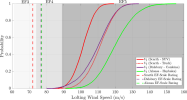
reason why im saying this is enderlin's EF5 rating came form a paper and that paper has alonsa as a 100% EF5 rating using the same logic
link here https://journals.ametsoc.org/view/journals/mwre/152/8/MWR-D-23-0251.1.xml

1762521497233.png
scarth truck thrown distance came close as well, and all other tornadoes in this paper seem to be in the more then 90% chance of being EF5 in wind speed.

all im saying is any tornado in this paper that has the min probability at or over 90 ms should be rated EF5 , and if they are not then enderlin's EF5 rating main reason is thrown out of the window.

a other tornado that could likely be locked in with alonsa , enderlin's rating is tuscaloosa as it did the same exact thing that enderlin did.

however its not calculated in this paper yet.

personally i would say upgrade alonsa to 205 mph and slightly downgrade enderlin to 205 mph base on the fact the track cars were not thrown however EF5 winds are still needed for enderlin train car bouncing and rolling it did.

extra note about alonsa is the wind speed in this paper is at 203 mph to 347 mph , this is the highest modern day mph calculation from a known tornado known for the max range.
 
I wish there was solid, verifiable construction information on the Eiland Plaza Apartments. I have never, before or since, seen a tornado fully slab a multi-story brick veneer apartment building like that. The official 185 MPH EF4 rating makes me infer that there was something seriously wrong, like the building was only attached to its foundation via carpentry nails or something (this can happen, as we saw at Chastain Manor in Tuscaloosa). However on the other hand, that’s an assumption, and if there was any degree of reasonable anchoring via bolts, there’d be no way to defend the EF4 rating.

When it comes to unanswered questions about instances of tornado damage, details regarding the construction quality at Eiland Plaza is near the top of the list for me. I’ve been wanting a definitive answer for a very long time.
I think if you were to contact NWS Jackson and see if they have survey photos from that area or ask about the construction quality of the apartments they’d give a pretty definitive answer given their reputation. I myself would love to get to the bottom of that DI as well.

I do agree that Louisville was absolutely an EF5-strength tornado, and does have a potential DI reflecting that intensity as well. The contextual damage from that thing is absolutely upper-echelon. It produced some of the most extreme tree damage I’ve seen from Dixie Alley, on par with the 4/27/11 EF5’s and Bassfield.
 
Back
Top