WeathermanLeprechaun
Member
That's absolutely incredible if legit and Melissa is genuinely sustaining. I didn't think I'd see something like Milton for a while but oh my word
Follow along with the video below to see how to install our site as a web app on your home screen.
Note: This feature may not be available in some browsers.
Well, not at the surface - 160 - 170 at the surface. 200+ a few hundred feet up though. Screaming. The 170KTs isn't dropsonde measured. Dropsonde is the official, SFMR is a radar estimate, basically.So 195+!? In a HURRICANE!?
Product: Air Force Vortex Message (URNT12 KNHC)
Corrected: This observation corrected a previous observation.
Transmitted: 27th day of the month at 16:08Z
Agency: United States Air Force
Aircraft: Lockheed WC-130J Hercules with reg. number AF98-5308
Storm Name: Melissa
Storm Number & Year: 13 in 2025 (flight in the North Atlantic basin)
Mission Number: 20
Observation Number: 26
A. Time of Center Fix: 27th day of the month at 15:46:20Z
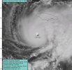
B. Center Fix Coordinates: 16.35N 78.19W
B. Center Fix Location: 147 statute miles (237 km) to the SW (218°) from Kingston, Jamaica.
C. Minimum Height at Standard Level: 2,325m (7,628ft) at 700mb
D. Minimum Sea Level Pressure: 909mb (26.85 inHg)
E. Dropsonde Surface Wind at Center: From 150° at 17kts (From the SSE at 20mph)
F. Eye Character: Closed
G. Eye Shape & Diameter: Circular with a diameter of 10 nautical miles (12 statute miles)
H. Estimated (by SFMR or visually) Maximum Surface Wind Inbound: 149kts (171.5mph)
I. Location & Time of the Estimated Maximum Surface Wind Inbound: 7 nautical miles to the NE (41°) of center fix at 15:44:00Z
J. Maximum Flight Level Wind Inbound: From 127° at 161kts (From the SE at 185.3mph)
K. Location & Time of the Maximum Flight Level Wind Inbound: 7 nautical miles to the NE (41°) of center fix at 15:44:00Z
L. Estimated (by SFMR or visually) Maximum Surface Wind Outbound: 163kts (187.6mph)
M. Location & Time of the Estimated Maximum Surface Wind Outbound: 6 nautical miles to the NNW (347°) of center fix at 15:52:00Z
N. Maximum Flight Level Wind Outbound: From 75° at 156kts (From the ENE at 179.5mph)
O. Location & Time of the Maximum Flight Level Wind Outbound: 6 nautical miles to the NNW (347°) of center fix at 15:52:00Z
P. Maximum Flight Level Temp & Pressure Altitude Outside Eye: 9°C (48°F) at a pressure alt. of 3,059m (10,036ft)
Q. Maximum Flight Level Temp & Pressure Altitude Inside Eye: 25°C (77°F) at a pressure alt. of 3,037m (9,964ft)
R. Dewpoint Temp (collected at same location as temp inside eye): 8°C (46°F)
R. Sea Surface Temp (collected at same location as temp inside eye): Not Available
S. Fix Determined By: Penetration, Radar, Wind, Pressure and Temperature
S. Fix Level: 700mb
T. Navigational Fix Accuracy: 0.02 nautical miles
T. Meteorological Accuracy: 1 nautical mile
Remarks Section:
Maximum Flight Level Wind: 161kts (~ 185.3mph) which was observed 7 nautical miles to the NE (41°) from the flight level center at 15:44:00ZIndeed.Hearing this from lots of people but apparently its eye is 25C.
What even is the limit? I just don't know how high this things gonna goI believe we're approaching the theoretical physical limit of hurricane strength in the Atlantic basin in terms of wind speed.
I believe we're approaching the theoretical physical limit of hurricane strength in the Atlantic basin in terms of wind speed.
Allen’s 190mph is gonna be tough to beat. Would have to pack on about 20 mph in 16 hours or so.What even is the limit? I just don't know how high this things gonna go
There is technically a limit at any given location/time within the atmosphere but I imagine it's something ill-defined at best. I imagine the height of the tropopause at any given location within a basin is strongly correlated to the maximum possible strength a TC can reach, at least in terms of central pressure.What even is the limit? I just don't know how high this things gonna go