Navigation
Install the app
How to install the app on iOS
Follow along with the video below to see how to install our site as a web app on your home screen.
Note: This feature may not be available in some browsers.
More options
-
Welcome to TalkWeather! We see you lurking around TalkWeather! Take the extra step and join us today to view attachments, see less ads and maybe even join the discussion. CLICK TO JOIN TALKWEATHER
You are using an out of date browser. It may not display this or other websites correctly.
You should upgrade or use an alternative browser.
You should upgrade or use an alternative browser.
Hurricane Melissa
- Thread starter Jacob Aden
- Start date
TornadoFan
Member
Melissa now up to 90 MPH with pressure down to 974 mb as of the 5 PM update.
Looks like that latest track takes Melissa right on the cusp or over the highest OHC (Oceanic Heat Content) that @Blountwolf pointed out yesterday
N0mz
Member
Forecast to cat 5 48 hours from now
lake.effect
Member
What's the surge potential around Kingston?
Considering all the factors that determine surge (duration of onshore winds, size of fetch, strength of fetch, bathymetry of the coastline, etc) and the most likely approach angle, Kingston could be facing a major storm surge disaster.
At this time it appears Melissa will not be a particularly large hurricane in terms of wind field, which is perhaps the only mitigating factor.
Is 20+ feet of surge somewhere near Kingston a possibility here?
N0mz
Member
9-13 feet is mentioned in the current public advisory, but that was revised up from 5-10 last advisoryWhat's the surge potential around Kingston?
Considering all the factors that determine surge (duration of onshore winds, size of fetch, strength of fetch, bathymetry of the coastline, etc) and the most likely approach angle, Kingston could be facing a major storm surge disaster.
At this time it appears Melissa will not be a particularly large hurricane in terms of wind field, which is perhaps the only mitigating factor.
Is 20+ feet of surge somewhere near Kingston a possibility here?
tornado examiner
Member
Cat 5 now explicitly forecast.
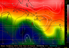
Shear now dropping in front of her.

Yeah - the track toward the hot pools is not giving me much hope for a miracle.


Looks like that latest track takes Melissa right on the cusp or over the highest OHC (Oceanic Heat Content) that @Blountwolf pointed out yesterday
Yeah - the track toward the hot pools is not giving me much hope for a miracle.

lake.effect
Member
9-13 feet is mentioned in the current public advisory, but that was revised up from 5-10 last advisory
Gotcha, thanks.
That seems a bit low for a stalled cat 5 in relatively shallow water. I guess the size of the windfield is the limiting factor here.
Jamaica has the benefit with storm surge of being fairly mountainous compared to many islands. Still, definitely going to be some places go under.9-13 feet is mentioned in the current public advisory, but that was revised up from 5-10 last advisory

And if landfall is Hunters Village or west, that will mean a lot of hours of it wind piling water into those bays.
N0mz
Member
Yep, more worried about all the water rushing down the mountainsJamaica has the benefit with storm surge of being fairly mountainous compared to many islands. Still, definitely going to be some places go under.
View attachment 47773
lake.effect
Member
The mountains are pretty much irrelevant to the surge threat here since much/most of the population is clustered in the flat, low-lying areas near the coast.
N0mz
Member
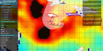
Do the blacks just mean the scale is maxed out?Shear now dropping in front of her.
View attachment 47770
Yeah - the track toward the hot pools is not giving me much hope for a miracle.
View attachment 47771
TornadoFan
Member
And an interesting coincidence is that if Melissa does become a Category 5 hurricane, it would be the third one of this season, which would be the first time since 2005 that the Atlantic officially produced more than two Category 5 hurricanes.
Been thinking about that as well.And an interesting coincidence is that if Melissa does become a Category 5 hurricane, it would be the third one of this season, which would be the first time since 2005 that the Atlantic officially produced more than two Category 5 hurricanes.
N0mz
Member
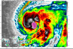
Definitely starting to spiral up with that new convection
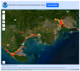
I've got to disagree with you there, at least in terms of the permanent population. Most of Kingston, all of Saint Catherine, etc. - all up off the water enough that surge isn't a huge risk, at least according to the model I posted above. Reality may differ from modeling, of course. The tourist areas are what are clustered in the low-lying areas near the coast. Unfortunately, the permanent population mostly living up off the water isn't going to help them from being shredded by the winds, which are going to be enough to cause destruction island-wide, I'm afraid.The mountains are pretty much irrelevant to the surge threat here since much/most of the population is clustered in the flat, low-lying areas near the coast.
Yes.Do the blacks just mean the scale is maxed out?
It’s just so interesting that the Atlantic has been able to spit out Cat 5s like it’s nothing this year, even with the issues this season has faced.Been thinking about that as well.

