WeathermanLeprechaun
Member
Oh, yeah, the thread still accounts for the 19th. My bad!Psst...need to put these in your weekend thread.")
Follow along with the video below to see how to install our site as a web app on your home screen.
Note: This feature may not be available in some browsers.
Oh, yeah, the thread still accounts for the 19th. My bad!Psst...need to put these in your weekend thread.
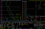
How does Houston look? I may make the time for a chase.My eyes are on the 24th for a low end severe threat in the OK/AR/TX vicinity, all hazards would be possible. Sounding from SE OK. A bit of low level curvature and adequate instability.
Maybe the chance for severe storms, perhaps all hazards but storms appear to be elevated so damaging wind and hail more soHow does Houston look? I may make the time for a chase.
Ah okay. Good to know. Regardless, seems like the south may get quite a few days of severe weather.Maybe the chance for severe storms, perhaps all hazards but storms appear to be elevated so damaging wind and hail more so
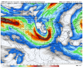
Was just looking at that, it's rather impressive.Meanwhile, the 18z GFS severe weather threat October 28th

Indeed it is.Was just looking at that, it's rather impressive.


My interest level is increasing for late this weekend. For mid south Dixie regionsDay 4-8:
...DISCUSSION...
Severe storm potential is likely to increase through the extended
forecast period as a series of upper troughs and enhanced
southwesterly flow aloft return to the central and southeastern
CONUS. The primary uncertainty remains the degree of moisture return
and instability.
...D4/Thursday-D6/Saturday Southern Plains/ArkLaTex...
A shortwave trough will cross the southern Rockies into the High
Plains supporting lee cyclogenesis Thursday and Thursday night. In
the wake of the earlier frontal passage, modest low-level moisture
return is expected to take place east of the low and a lee trough
over the southern Plains as a warm front lifts northward. Cooling
mid-level temperatures will allow for diurnal destabilization and
some organized severe potential as westerly flow aloft also
increases. Strong to potentially severe storms are possible
D4/Thursday and D5/Friday in vicinity of the surface low and warm
front across KS/OK, and along the lee trough into the TX Panhandle.
However, confidence in the overall severe risk and its evolution is
low, pending sufficient moisture return and the timing of the upper
trough.
Some severe potential will likely shift eastward into the ArklaTex
D6/Saturday as the upper low moves eastward and low-level moisture
return continues. Confidence in the severe risk is limited, owing to
the potential for several prior days of convection.
...Eastern Plains and Mid MS Valley D7-D8...
Greater severe potential may develop towards the end of the extended
forecast period as a deep upper trough matures over the Plains
D7/Sunday and moves into the Midwest/MS Valley D8/Monday. Ensemble
and deterministic guidance show a strong cold front and low with
sufficient moisture/instability for severe storms capable of all
hazards from the eastern Plains and MS Valley late this weekend into
early next week. 15% severe probabilities could be needed in future
outlook cycles should model solutions converge on timing and
location of the greatest severe risk.