Navigation
Install the app
How to install the app on iOS
Follow along with the video below to see how to install our site as a web app on your home screen.
Note: This feature may not be available in some browsers.
More options
-
Welcome to TalkWeather! We see you lurking around TalkWeather! Take the extra step and join us today to view attachments, see less ads and maybe even join the discussion. CLICK TO JOIN TALKWEATHER
You are using an out of date browser. It may not display this or other websites correctly.
You should upgrade or use an alternative browser.
You should upgrade or use an alternative browser.
Severe Weather 2025
- Thread starter KevinH
- Start date
Ozonelayer
Member

Well hello there...
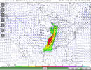
HUGE jump from past runs so this could (and probably is) an outlier run, but interesting nonetheless. If this becomes a trend then it could become concerning but as of now there is only one GFS run showing this. While there has been a slight uptick in past GFS runs (12z-18z Yesterday), the 00z from this morning showed a much less concerning scenario and this is a massive jump from even the 18z yesterday.
I wouldn't be too concerned but I would keep an eye on trends, and if they continue in this direction then start paying attention.
It would not surprise me to see a Enhanced upgrade. You definitely have the near 20 degree temp drop (87 to 69) from Saturday to Sunday and Southerly wind component Saturday which means moisture will not be hindered at all.
I was thinking about making a thread but I don't think the event warrants it yet. If we see a enchanced risk or a 10% tornado risk I think I'll go ahead. 
I think this'll be a good ole gully washer, any substantial tornado risk will be short and mainly confined to anything semi discreet before congealment. Just a usual spin up QLCS tornado threat from that point on. And some brisk temperatures afterwords. Damaging wind threat will be the biggest issue from this event.
WeathermanLeprechaun
Member
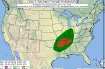
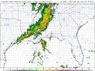
Given the disagreement, i can't judge the 5% placement that much but i personally think our genuine tor threat lies in Dixie. As you go into that 1am-4am period Sine in S MS and SW AL, a weakish QLCS with enough instability and shear may promote a couple brief spinups. based on what I've seen, this area does have better agreement for a tor threat. I personally do think the damaging wind threat will last a bit long but then shift to potentially tornadic throughout the night. There is the possibility the line remains elevated and wind remains the main threat but a few brief spinups are not out of the question with latest guidance. This has been a tough forecast but think this might be where I stick with it haha
Attachments
Kds86z
Member
warneagle
Member
kind of wild that Virginia has only had 1 EF0 all year, although we didn't get a ton of storms in general this year
Ozonelayer
Member
Also wild seeing a state colored pink for the first time in over a decade.kind of wild that Virginia has only had 1 EF0 all year, although we didn't get a ton of storms in general this year
Kds86z
Member
The surprise is Illinois.. and not a single fatality.kind of wild that Virginia has only had 1 EF0 all year, although we didn't get a ton of storms in general this year
- Moderator
- #7,111
Since we have a slight risk over a fairly large area for tomorrow, if someone wants to fire up a thread go for it.
- Moderator
- #7,112
I will take this as a opportunity to start my very first thread, and also pave the way for further discussion given the 5% tornado risk has been massively extended in the latest outlook! Several QLCS tornadoes appear possible tomorrow with how decently sized this 5% is.
- WeathermanLeprechaun
- Replies: 233
- Forum: General Weather Discussion
I thought you made the thread Michelle, I was about to say uh oh… LOLI will take this as a opportunity to start my very first thread, and also pave the way for further discussion given the 5% tornado risk has been massively extended in the latest outlook! Several QLCS tornadoes appear possible tomorrow with how decently sized this 5% is.
- WeathermanLeprechaun
- Replies: 233
- Forum: General Weather Discussion
For those of you that don’t get the reference, @MichelleH is a talkweather OG and was actually the person that made the severe weather thread for the 2011 super outbreak a week in advance!I thought you made the thread Michelle, I was about to say uh oh… LOL
Kds86z
Member
Ozonelayer
Member
Kds86z
Member
We got a threadView attachment 47493
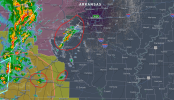
We might have some prefrontals. Favorable storm motion, southerly flow, and an okay environment as of now might allow them to cause problems in the future if they can mature before the line swallows them up.
Ozonelayer
Member
Okay!We got a thread
Kds86z
Member
Okay!
I will take this as a opportunity to start my very first thread, and also pave the way for further discussion given the 5% tornado risk has been massively extended in the latest outlook! Several QLCS tornadoes appear possible tomorrow with how decently sized this 5% is.
- WeathermanLeprechaun
- Replies: 233
- Forum: General Weather Discussion
The consistency between models being displayed for the Oct 27-29th system is worrisome. Still 10 days out, but if it sticks around for longer, this is the type of thing you only see preceding intense severe weather.


