• Welcome to TalkWeather!
    We see you lurking around TalkWeather! Take the extra step and join us today to view attachments, see less ads and maybe even join the discussion.
    CLICK TO JOIN TALKWEATHER

Severe Weather 2025

View attachment 47425
my god, its to note the VTP would be showing up as 57.5
on my corrected VTP its at 14.3 , you can check that out here

happy joshoctober16th?!

but thanks for putting this together, even a liberal arts major like me can get some use out of this
 
happy joshoctober16th?!

but thanks for putting this together, even a liberal arts major like me can get some use out of this
misread that as (a liberal ant major).

anyhow i made CVTP because...

1:the original VTP has a major cap/limit issue with parameters like 3cape and 3LR.
this caused events that showd up as 40 VTP when it was a blue sky Forecasted Convective Amplification Deficiency... (this limit on 3cape and 3LR made this event go down to 12.3)

2:there is no moister in any tornado composite parameter. the CVTP now takes into account moister , pretty much 60-90% is good but when it gets lower or higher then that the CVTP number gets lower.

3: LCL has been changed , there were tornado events that happened with LCL over 2.1 km so its been pushed further, instead of being cap at 1 km now it caps at 0.7 km , however if it goes under 0.2 km (200 meters) it starts to lower the number as less then 200 meter events tend to be stratus rain mess.

4:ESRH is halved in power however i added in SRH3 to this composite parameter , they work together to and merged (divided by 2) , this was made to get rid of a super rare issue that could happen (only one tornado sufferd from this old problem and it was one of the F5 candidates on the Canadian papers)

it is to note CAPE / ESRH / SRH3 / RH are also all cap , however the CAPE and SRH take a very high number to get cap.

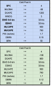
the other composite parameter DBRN , was made for 2 reasons.

1:without DBRN may 19 2019 tends to look like a superoutbreak event without it , and its just awkward to look at this event that has every other parameter looking perfect and a big Forecasted Convective Amplification Deficiency happens.
2:nudger theory video states if a storm is too inflow dominant the mesos will keep being sling shot away without anything ever happening or when its too outflow dominant it will tend to do a QLSC Forecasted Convective Amplification Deficiency event like may 19 2019.

while i know these inflow dominant Forecasted Convective Amplification Deficiency exist and i have watched them live , i sadly cant remember what events they were.
however there were data of the outflow events.
interesting note the Pilger event had the lowest number on the DBRN without having a Forecasted Convective Amplification Deficiency , being around 0.113.
however using a list of different parameter + the DBRN you can get the Pilger event being in a non outflow Forecasted Convective Amplification Deficiency
1760637955732.png

anyhow that's some of the info on these 2 parameters and why i made them.
this is a severe weather thread and i don't want this thread to overflow about only composite parameters.
however here is a link to a thread about composite parameters.
https://talkweather.com/threads/gen...rd-type-sars-and-other-parameters.2416/page-5
 
Last edited:
What the heck did I just walk into lol

Dontgetit What GIF by KSANA
 
What the heck did I just walk into lol
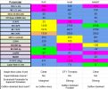
Long story short NAM soundings are producing high violent tornado parameters, and his "corrected" violent tornado parameter are between 8ish and 12ish.

Here's his CVTP scale.

1760644010027.png

and the thread text is somehow editing parts by it self...
View attachment 47435

what i put and what it shows in edit mode
View attachment 47436

???? the heck is going on here?

This has been a thing since March haha.
 
oh woops.. i never ment to make it appear like that... i just ment to give the link and not this strange .... embedded thing mode

let me try this again....
( docs.google.com/spreadsheets/d/1EHx8-4Tn6hmx3Um8x7YBVEHf4UUvL1A0_e9TfN3bR6U/edit?usp=sharing )

just put in the (https://) part infront , im not sure why it puts a strange media mode on by it self , but i never ment to do that.

This is awesome! Been plugging some soundings into your chart and the way you've designed it is really impressive and straight forward.
 
While i think strong forcing will promote a QLCS with several embedded spinups, I'm thinking a prefrontal threat isn't entirely out of the question with Saturday.

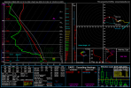
The NAM3km is very bullish on kinematics in the vicinity of NW AR, and this is a sounding in the area which is potent but I'm not putting to much trust into this yet.

I have a feeling Saturday is a "there's more then meets the eye" type day and mesoscale details can quickly change the day. If we end up getting cells ahead of the line, then this sounding would suggest significant tornadoes. My confidence is low (atm in this scenario) and think a QLCS with still, several embedded spinups and possibly a strong one or two given the magnitude of low level shear.

Please correct me if i am thinking wrong about the prefrontal scenario, I must say i am not too well versed in how to forecast prefrontals but it's just a thought I'll throw out there in case. This is not really a forecast, but a personal opinion on the day itself. Do not take this as a guidance if you live in the areas with severe weather outlined in Saturday, i can easily be wrong here!
 

Attachments

  • nam4km_2025101612_060_35.89--93.38.png
    nam4km_2025101612_060_35.89--93.38.png
    244.1 KB · Views: 0
Last edited:
While i think strong forcing will promote a QLCS with several embedded spinups, I'm thinking a prefrontal threat isn't entirely out of the question with Saturday.

The NAM3km is very bullish on kinematics in the vicinity of NW AR, and this is a sounding in the area which is potent but I'm not putting to much trust into this yet.

I have a feeling Saturday is a "there's more then meets the eye" type day and mesoscale details can quickly change the day. If we end up getting cells ahead of the line, then this sounding would suggest significant tornadoes. My confidence is low (atm in this scenario) and think a QLCS with still, several embedded spinups and possibly a strong one or two given the magnitude of low level shear.

Please correct me if i am thinking wrong about the prefrontal scenario, I must say i am not too well versed in how to forecast prefrontals but it's just a thought I'll throw out there in case. This is not really a forecast, but a personal opinion on the day itself. Do not take this as a guidance if you live in the areas with severe weather outlined in Saturday, i can easily be wrong here!
The environment definetly looks favorable for supercells. I agree with you that there could be prefrontals.

Im not a meteorologist, but the sounding seems to have some sort of cap. Shear and CAPE are sufficent, EHI isn't the highest but it isnt terrible either.

Lapse Rates could be higher but they are okay enough. Overall take my word with a grain of salt but I do think that prefrontals are possible. Given the environment I think prefontals, if they occur, would have the potential for multiple significant tornadoes and I don't think an intense tornado is out of the question either.
 
and the thread text is somehow editing parts by it self...
View attachment 47435

what i put and what it shows in edit mode
View attachment 47436

???? the heck is going on here?
The word that is shown on your second photo is something that's censored, and instead the system replaces it with FCAD.
The environment definetly looks favorable for supercells. I agree with you that there could be prefrontals.

Im not a meteorologist, but the sounding seems to have some sort of cap. Shear and CAPE are sufficent, EHI isn't the highest but it isnt terrible either.

Lapse Rates could be higher but they are okay enough. Overall take my word with a grain of salt but I do think that prefrontals are possible. Given the environment I think prefontals, if they occur, would have the potential for multiple significant tornadoes and I don't think an intense tornado is out of the question either.
Oh yeah, of course. I didn't mention the quirks in the sounding but yeah, lapse rates are a issue if we go by that plus that "warm nose" being featured.
 
Long story short NAM soundings are producing high violent tornado parameters, and his "corrected" violent tornado parameter are between 8ish and 12ish.

Here's his CVTP scale.

View attachment 47440


This has been a thing since March haha.
Oh I know what he’s calculating lol. Not to come across as harsh, but I’m just not sure how applicable and scientifically accurate it is. I can point to an event from 2024 that had VTPs nearly maxed out and not a single storm went through that environment.
 
Oh I know what he’s calculating lol. Not to come across as harsh, but I’m just not sure how applicable and scientifically accurate it is. I can point to an event from 2024 that had VTPs nearly maxed out and not a single storm went through that environment.
I was gonna mention this too. This blog post from Quincy Vagell perfectly explains why VTP is more of a failure in most days then a success despite what people hype it up for. https://www.quincyvagell.com/2019/03/21/violent-tornado-parameter/
 
Exactly. Then you have the case where this “VTP” has been modified further.
Yeah, im all for experimenting with composite parameters but low level lapse rates and 3CAPE completely overblow the values. It works decently on high end days, and that's the only time i take a look at it. Any less and it's just a really bad fish in the dark
 
While i think strong forcing will promote a QLCS with several embedded spinups, I'm thinking a prefrontal threat isn't entirely out of the question with Saturday.

The NAM3km is very bullish on kinematics in the vicinity of NW AR, and this is a sounding in the area which is potent but I'm not putting to much trust into this yet.

I have a feeling Saturday is a "there's more then meets the eye" type day and mesoscale details can quickly change the day. If we end up getting cells ahead of the line, then this sounding would suggest significant tornadoes. My confidence is low (atm in this scenario) and think a QLCS with still, several embedded spinups and possibly a strong one or two given the magnitude of low level shear.

Please correct me if i am thinking wrong about the prefrontal scenario, I must say i am not too well versed in how to forecast prefrontals but it's just a thought I'll throw out there in case. This is not really a forecast, but a personal opinion on the day itself. Do not take this as a guidance if you live in the areas with severe weather outlined in Saturday, i can easily be wrong here!
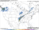
Just like that, the 18z NAM3km immediately makes me look like a fool! A tough forecast will continue!
 

Attachments

  • refcmp_uh001h.conus.png
    refcmp_uh001h.conus.png
    307.3 KB · Views: 0
Oh I know what he’s calculating lol. Not to come across as harsh but I’m just not sure how applicable and scientifically accurate it is.
Not harsh at all. That's a perfectly reasonable take. He put so much work into it, it's worth testing though. I plugged some soundings from East Oklahoma/NE Arkansas into his program just for fun and these were the results. Even the most intense soundings aren't tornado producers here, which is interesting. And outflow dominance is the common theme.

1760648087939.png
 
Oh I know what he’s calculating lol. Not to come across as harsh, but I’m just not sure how applicable and scientifically accurate it is. I can point to an event from 2024 that had VTPs nearly maxed out and not a single storm went through that environment.
the main problem with the old VTP is that LR3 and 3cape are uncapped , note the CVTP i made isn't perfect but it should be better then the original VTP.

my third composite parameter i am still making and should take a long time to finish should be the real big test.

then again i think all this talk should be more on the composite thread.

anyhow what 2024 event were you talking about?
curious to see how my CVTP is like for it.
 
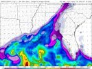
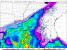
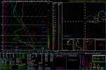
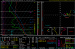
18Z NAM shows the very plausible alternative outcome for this scenario down South. Ironically, wind profiles are more favorable in the thermodynamically-limited environment, when the NAM is taken verbatim (soundings from around Rome, GA on the 18Z and 12Z runs, respectively). Don't think we see a major threat either way, but these changes could make substantial differences in what kind and how much severe activity we see.
1760650114443.png1760650120328.png1760650204118.png1760650207833.png
 
Back
Top