warneagle
Member
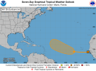
there's a new 0/30 lemon in the eastern Atlantic so I guess the climatological peak of hurricane season isn't technically a total nothingburger?
Follow along with the video below to see how to install our site as a web app on your home screen.
Note: This feature may not be available in some browsers.
Tangerine now.there's a new 0/30 lemon in the eastern Atlantic so I guess the climatological peak of hurricane season isn't technically a total nothingburger?
ZCZC MIATWOAT ALL
TTAA00 KNHC DDHHMM
Tropical Weather Outlook
NWS National Hurricane Center Miami FL
800 AM EDT Fri Sep 12 2025
For the North Atlantic...Caribbean Sea and the Gulf of America:
1. Eastern and Central Tropical Atlantic:
A tropical wave located near the west coast of Africa is producing
disorganized showers and thunderstorms over the far eastern
Atlantic. Environmental conditions appear conducive for some
gradual development of this system over the next several days. A
tropical depression could form by the middle part of next week while
it moves westward to west-northwestward at 10 to 15 mph over the
eastern and central tropical Atlantic.
* Formation chance through 48 hours...low...near 0 percent.
* Formation chance through 7 days...medium...40 percent.
Forecaster Berg

It’s sooo very odd to not see a single Gulf track on the track maps though now Mid-September. And that’s comparing it to the barrage of Gulf storms from 2016 though 2024.So looks like it's very likely 92L will recurve (but not guaranteed yet). The wave behind it may be more of a wild card.
InsnseJust look at this (no U.S. Gulf landfalls yet):
View attachment 46568
Gabrielle to come @Atlantic.Just look at this (no U.S. Gulf landfalls yet):
View attachment 46568
But soon-to-be Gabrielle will likely also be a recurving hurricane like Erin thankfully:Gabrielle to come @Atlantic.
Which is goodBut soon-to-be Gabrielle will likely also be a recurving hurricane like Erin thankfully:
