The TWO (Tropical Weather Outlook) Mapswhat exactly are you trying to look for with a hurricane archive there are places like wikipedia if that can help hopefully its not a whole lot but at least maybe some info about say hurricane andrew for example and that was from 1992 who knows maybe people or someone posts about tropical systems from the past on x or social media but im not sure if its every single one maybe also youtube hopefully all that helps
Navigation
Install the app
How to install the app on iOS
Follow along with the video below to see how to install our site as a web app on your home screen.
Note: This feature may not be available in some browsers.
More options
-
Welcome to TalkWeather! We see you lurking around TalkWeather! Take the extra step and join us today to view attachments, see less ads and maybe even join the discussion. CLICK TO JOIN TALKWEATHER
You are using an out of date browser. It may not display this or other websites correctly.
You should upgrade or use an alternative browser.
You should upgrade or use an alternative browser.
2025 Global Tropical Cyclone Season Discussion
- Thread starter Atlantic
- Start date
KakashiHatake2000
Member
ooh okay i seeThe TWO (Tropical Weather Outlook) Maps
Something is cooking in the Quintana Roo.
(Well, more like off the coast of Honduras, but close enough, and Quintana Roo is more fun to say.)
IJS
(Well, more like off the coast of Honduras, but close enough, and Quintana Roo is more fun to say.)
IJS
KakashiHatake2000
Member
- Thread starter
- #905
KakashiHatake2000
Member
gotcha atlantic i wasnt really sure where to post that since its a joke with models wearing spaghetti clothing
- Thread starter
- #907
Brief update on the non-Atlantic tropics.
- Podul peaked at 90 kts (110 mph) and moved over Southern Taiwan. It continued to weaken though landfall in China and it is now dissipated.
- We now have an Invest 90W out at 7.2°N 169.4°E, pretty far east in the WPAC. Closer to the International Date Line than to China. It could move westwards for several days and possibly become a TC beyond 7 days as it moves near China
Years where the Atlantic has had its first category 5 before the Western Pacific:
2025
2024
1992
1988
1980
1979
1977
1969
2024 and 2025 are the first 2 consecutive years on record.
2025
2024
1992
1988
1980
1979
1977
1969
2024 and 2025 are the first 2 consecutive years on record.
- Thread starter
- #909
Three Invests have been present in the Western Pacific recently. The first was in the South China Sea west of the Philippines. It became short-lived Tropical Depression 17W, the third year in a row that a 17W has failed to be named by JMA.
The second invest formed into Tropical Depression 18W southwest of the southernmost tip of Japan. It became Tropical Storm Lingling last night after JMA named it. It has the Philippine name Huaning.
The third invest started out near 160-165*E and was briefly upgraded to a medium chance invest according to the JTWC, before being downgraded to low again. It is Invest 90W and it is approaching the Philippines right now. The EURO model wants it to go straight west through the Philippines and into the South China Sea while continuing almost due west.
We have a 40/70 AoI in the Atlantic alongside 40/40 Invest 99L and a newly introduced 30/30 small area of low pressure expected to continue eastwards.
We also have a 0/30 AoI in the Eastern Pacific to watch for the potential to develop into a TC
Interestingly, CSU does not list Typhoon Danas as a category 3, so based off this, the Western Pacific still has not had a major typhoon.
 tropical.atmos.colostate.edu
Real-Time Northwest Pacific Ocean Statistics compared with climatology
- Thread starter
- #911
The Western Pacific is pulling an Atlantic 2012.Interestingly, CSU does not list Typhoon Danas as a category 3, so based off this, the Western Pacific still has not had a major typhoon.
Real-Time Northwest Pacific Ocean Statistics compared with climatology
tropical.atmos.colostate.edu
2012 had a high number of named storms and hurricanes but an unusually low number of major hurricanes, with 2 occurring. Both only peaked at 100 kts (barely a major hurricane at all)
- Thread starter
- #912
Invest 90W was upgraded to high chance by the JTWC yesterday evening, and it is appearing more than likely that it will form in the South China Sea. Should JMA name it, the next name is Kajiki
90W has also received the local Philippine name Isang.
90W has also received the local Philippine name Isang.
- Thread starter
- #913
Invest 90W’s TCFA:Invest 90W was upgraded to high chance by the JTWC yesterday evening, and it is appearing more than likely that it will form in the South China Sea. Should JMA name it, the next name is Kajiki
90W has also received the local Philippine name Isang.

WTPN21 PGTW 212230
MSGID/GENADMIN/JOINT TYPHOON WRNCEN PEARL HARBOR HI//
SUBJ/TROPICAL CYCLONE FORMATION ALERT (INVEST 90W)//
RMKS/
1. FORMATION OF A SIGNIFICANT TROPICAL CYCLONE IS POSSIBLE WITHIN
120 NM EITHER SIDE OF A LINE FROM 16.1N 123.4E TO 17.0N 117.1E
WITHIN THE NEXT 12 TO 24 HOURS. AVAILABLE DATA DOES NOT JUSTIFY
ISSUANCE OF NUMBERED TROPICAL CYCLONE WARNINGS AT THIS TIME.
WINDS IN THE AREA ARE ESTIMATED TO BE 20 TO 25 KNOTS. METSAT
IMAGERY AT 211800Z INDICATES THAT A CIRCULATION CENTER IS LOCATED
NEAR 16.1N 123.3E. THE SYSTEM IS MOVING WESTWARD AT 11 KNOTS.
2. REMARKS:THE AREA OF CONVECTION (INVEST 90W) PREVIOUSLY LOCATED NEAR
15.9N 126.8E IS NOW LOCATED NEAR 16.1N 123.3E, APPROXIMATELY 71 NM EAST
OF CASIGURAN, PHILIPPINES. ANIMATED MULTISPECTRAL SATELLITE IMAGERY
(MSI) AND A 212053Z GMI 89GHZ MICROWAVE IMAGE DEPICT A COMPACT,
PARTIALLY EXPOSED LOW-LEVEL CIRCULATION CENTER (LLCC) WITH PERSISTENT
CONVECTION ALONG THE EASTERN PERIPHERY OF THE CIRCULATION. ENVIRONMENTAL
ANALYSIS REVEALS A FAVORABLE ENVIRONMENT FOR DEVELOPMENT WITH LOW (10-15
KNOTS) NORTHERLY VERTICAL WIND SHEAR, STRONG EQUATORWARD OUTFLOW, AND
VERY WARM (30-31 C) SEA SURFACE TEMPERATURES. THE DEFINED CIRCULATION IS
EXPECTED TO QUICKLY MAKE LANDFALL ALONG THE EASTERN COAST OF LUZON AND
EMERGE WITHIN THE SOUTH CHINA SEA. DETERMINISTIC AND ENSEMBLE MODELS ARE
IN AGREEMENT THAT THE SYSTEM WILL TRACK WESTWARD OVER LUZON AND
INTENSIFY WITHIN THE SOUTH CHINA SEA AFTER RECOVERING FROM THE IMMINENT
LANDFALL. MAXIMUM SUSTAINED SURFACE WINDS ARE ESTIMATED AT 20 TO 25
KNOTS. MINIMUM SEA LEVEL PRESSURE IS ESTIMATED TO BE NEAR 1006 MB. THE
POTENTIAL FOR THE DEVELOPMENT OF A SIGNIFICANT TROPICAL CYCLONE WITHIN
THE NEXT 24 HOURS IS UPGRADED TO HIGH.
3. THIS ALERT WILL BE REISSUED, UPGRADED TO WARNING OR CANCELLED BY
222230Z.
//
NNNN
- Thread starter
- #914
- Thread starter
- #915
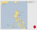
This became Tropical Depression 19W earlier today. JMA upgraded it from tropical depression “b” (since Lingling was active at the same time in the same basin) to Tropical Storm Kajiki. This one is likely to become a Typhoon in the South China Sea while being a straight runner (going nearly due west)Invest 90W’s TCFA:
View attachment 46271
WTPN21 PGTW 212230
MSGID/GENADMIN/JOINT TYPHOON WRNCEN PEARL HARBOR HI//
SUBJ/TROPICAL CYCLONE FORMATION ALERT (INVEST 90W)//
RMKS/
1. FORMATION OF A SIGNIFICANT TROPICAL CYCLONE IS POSSIBLE WITHIN
120 NM EITHER SIDE OF A LINE FROM 16.1N 123.4E TO 17.0N 117.1E
WITHIN THE NEXT 12 TO 24 HOURS. AVAILABLE DATA DOES NOT JUSTIFY
ISSUANCE OF NUMBERED TROPICAL CYCLONE WARNINGS AT THIS TIME.
WINDS IN THE AREA ARE ESTIMATED TO BE 20 TO 25 KNOTS. METSAT
IMAGERY AT 211800Z INDICATES THAT A CIRCULATION CENTER IS LOCATED
NEAR 16.1N 123.3E. THE SYSTEM IS MOVING WESTWARD AT 11 KNOTS.
2. REMARKS:THE AREA OF CONVECTION (INVEST 90W) PREVIOUSLY LOCATED NEAR
15.9N 126.8E IS NOW LOCATED NEAR 16.1N 123.3E, APPROXIMATELY 71 NM EAST
OF CASIGURAN, PHILIPPINES. ANIMATED MULTISPECTRAL SATELLITE IMAGERY
(MSI) AND A 212053Z GMI 89GHZ MICROWAVE IMAGE DEPICT A COMPACT,
PARTIALLY EXPOSED LOW-LEVEL CIRCULATION CENTER (LLCC) WITH PERSISTENT
CONVECTION ALONG THE EASTERN PERIPHERY OF THE CIRCULATION. ENVIRONMENTAL
ANALYSIS REVEALS A FAVORABLE ENVIRONMENT FOR DEVELOPMENT WITH LOW (10-15
KNOTS) NORTHERLY VERTICAL WIND SHEAR, STRONG EQUATORWARD OUTFLOW, AND
VERY WARM (30-31 C) SEA SURFACE TEMPERATURES. THE DEFINED CIRCULATION IS
EXPECTED TO QUICKLY MAKE LANDFALL ALONG THE EASTERN COAST OF LUZON AND
EMERGE WITHIN THE SOUTH CHINA SEA. DETERMINISTIC AND ENSEMBLE MODELS ARE
IN AGREEMENT THAT THE SYSTEM WILL TRACK WESTWARD OVER LUZON AND
INTENSIFY WITHIN THE SOUTH CHINA SEA AFTER RECOVERING FROM THE IMMINENT
LANDFALL. MAXIMUM SUSTAINED SURFACE WINDS ARE ESTIMATED AT 20 TO 25
KNOTS. MINIMUM SEA LEVEL PRESSURE IS ESTIMATED TO BE NEAR 1006 MB. THE
POTENTIAL FOR THE DEVELOPMENT OF A SIGNIFICANT TROPICAL CYCLONE WITHIN
THE NEXT 24 HOURS IS UPGRADED TO HIGH.
3. THIS ALERT WILL BE REISSUED, UPGRADED TO WARNING OR CANCELLED BY
222230Z.
//
NNNN
| WTPQ51 RJTD 230000 RSMC TROPICAL CYCLONE ADVISORY NAME TS 2513 KAJIKI (2513) UPGRADED FROM TD ANALYSIS PSTN 230000UTC 17.6N 116.4E FAIR MOVE W 15KT PRES 998HPA MXWD 035KT GUST 050KT 30KT 120NM FORECAST 12HF 231200UTC 18.3N 114.2E 40NM 70% MOVE WNW 11KT PRES 996HPA MXWD 040KT GUST 060KT 24HF 240000UTC 18.3N 111.4E 57NM 70% MOVE W 13KT PRES 990HPA MXWD 050KT GUST 070KT 48HF 250000UTC 18.4N 107.5E 100NM 70% MOVE W 09KT PRES 965HPA MXWD 070KT GUST 100KT 72HF 260000UTC 19.1N 103.6E 140NM 70% TROPICAL DEPRESSION = |
- Thread starter
- #916
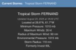
We have Tropical Storm Fernand from Invest 90L.
| AL, 06, 2025082318, , BEST, 0, 266N, 617W, 35, 1010, TS, 34, NEQ, 0, 90, 0, 0, 1015, 110, 90, 0, 0, L, 0, , 0, 0, FERNAND, S, 0, , 0, 0, 0, 0, genesis-num, 019, TRANSITIONED, alB02025 to al062025, |
- Thread starter
- #917
ATCF has updated too on CyclonicWx:We have Tropical Storm Fernand from Invest 90L.
AL, 06, 2025082318, , BEST, 0, 266N, 617W, 35, 1010, TS, 34, NEQ, 0, 90, 0, 0, 1015, 110, 90, 0, 0, L, 0, , 0, 0, FERNAND, S, 0, , 0, 0, 0, 0, genesis-num, 019, TRANSITIONED, alB02025 to al062025,

Welcome to the 6th named storm of the season. Only land it could impact is Bermuda, otherwise it is an OTS like Erin.
- Thread starter
- #918
- Thread starter
- #919
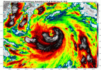
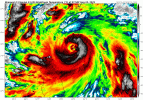
Typhoon Kajiki is quickly blowing up into a decently strong typhoon, with the 06Z ATCF setting the intensity at 90 kts (105 mph). It is expected to make landfall in northern Vietnam after moving into the southern Gulf of Tonkin not long now.
- Thread starter
- #920
JTWC expects Kajiki to peak at 105 kts now, but its eye has cleared out on infrared and I could see this pushing Cat 4 equivalent.Typhoon Kajiki is quickly blowing up into a decently strong typhoon, with the 06Z ATCF setting the intensity at 90 kts (105 mph). It is expected to make landfall in northern Vietnam after moving into the southern Gulf of Tonkin not long now.
Earlier

Near realtime now

