• Welcome to TalkWeather!
    We see you lurking around TalkWeather! Take the extra step and join us today to view attachments, see less ads and maybe even join the discussion.
    CLICK TO JOIN TALKWEATHER
  • TalkWeather Tropical Weather Widget
    Active Tropical Systems
    Loading...
    Fetching latest NHC data...

Significant Tornado Events

Richmond, KY F4
4/3/74

Photos taken from the EKU photos archive, honestly not much (comparatively to some other 4/3 tornadoes) out there on this one outside of some Facebook posts and images of the tornado itself, at least from what I could find, definitely violent however View attachment 45664View attachment 45665View attachment 45666View attachment 45667View attachment 45668View attachment 45669View attachment 45670
Being from this area, it thankfully skirted and missed downtown Richmond and hugged to the western parts of Madison County, which were at the time pretty rural. It’s a pretty decently sized college town, so damage potential would’ve been very high had it tracked through it. A student got some wicked photos of it from the top of a dormitory as it moved away from the city.

The parent storm actually originated a little northwest of Nashville and dropped the Mannsville F4 as well.

1754419887843.png
1754419918110.png
 
The 7/5/2000 Dailey CO F3 is supremely underrated; with this being a very rare nocturnal CO tornado, and a strong one at that.
No photos of it exist to my knowledge, with the "photo" of it being truly from a storm on 7/8/2000; not from Dailey.
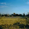
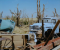
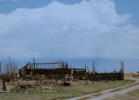
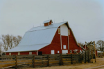
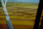
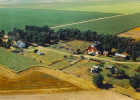
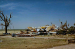
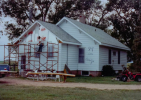
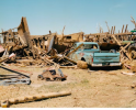
This tornado destroyed a farmstead owned by the Gordon family, who all survived with minor injuries; with one family member surviving by having a couch fall on top of them, sheltering them from flying debris.
Here's a few photos from a Colorado history Blog I have archived: (there's more but they're in a file type not accepted by the forum)
Plus, one by a Summer 2001 Colorado Climate magazine:
This tornado was a very rare Colorado wedge too, at 1,320 Yards wide
I got around to converting my other files! I do truly believe this tornado was violent; such as a mid range F4.
You can observe pretty extensive tree damage here in these; plus the near complete destruction of the Gordon Farm
 

Attachments

  • dmg 1.png
    dmg 1.png
    580.9 KB · Views: 0
  • dmg 4- vehicle.png
    dmg 4- vehicle.png
    878.3 KB · Views: 0
  • dmg 6.webp
    dmg 6.webp
    76.9 KB · Views: 0
  • dmg 8.png
    dmg 8.png
    914 KB · Views: 0
  • Gordon Fam Barn aftermath.png
    Gordon Fam Barn aftermath.png
    476.1 KB · Views: 0
  • Gordon Fam Barn Before.png
    Gordon Fam Barn Before.png
    459.3 KB · Views: 0
  • Gordon Fam farm- aerial view, after tor.png
    Gordon Fam farm- aerial view, after tor.png
    545.8 KB · Views: 0
  • Gordon Fam farm- aerial view, before, 1995.png
    Gordon Fam farm- aerial view, before, 1995.png
    896.1 KB · Views: 0
  • Gordon home-after tor.png
    Gordon home-after tor.png
    882.1 KB · Views: 0
  • Gordon home-before-1989.png
    Gordon home-before-1989.png
    894.1 KB · Views: 0
Also, unrelated to the image itself, I have zero doubt in my mind the Sawyerville tornado was violent in intensity. In my research while writing the article (which has since been published btw), I found that the tornado had 123 terajoules of kinetic energy at one point - twice as many as the Hiroshima nuclear bombing. It also had more TJs of energy than the Hackleburg EF5, Moore EF5, Ohatchee EF4 and Smithville EF5 (which is considered one of the strongest in world history).
 
Last edited:
Being from this area, it thankfully skirted and missed downtown Richmond and hugged to the western parts of Madison County, which were at the time pretty rural. It’s a pretty decently sized college town, so damage potential would’ve been very high had it tracked through it. A student got some wicked photos of it from the top of a dormitory as it moved away from the city.

The parent storm actually originated a little northwest of Nashville and dropped the Mannsville F4 as well.

View attachment 45679
View attachment 45680
Mannsville is another one that is pretty underrated, really wish there were more photos of the Chevy Impala it twisted up like a pretzel, the image is even crazier when you realize it's not even removed from its chassis, the whole intact car is just mangled that badly, those things are heavy as hell and sturdy, it's engine was embedded in a tree nearby but no images of that from what I know, I can't really pick a 2nd strongest Kentucky tornado from that day but both Richmond and Mannsville are up there for it.
 
Mannsville is another one that is pretty underrated, really wish there were more photos of the Chevy Impala it twisted up like a pretzel, the image is even crazier when you realize it's not even removed from its chassis, the whole intact car is just mangled that badly, those things are heavy as hell and sturdy, it's engine was embedded in a tree nearby but no images of that from what I know, I can't really pick a 2nd strongest Kentucky tornado from that day but both Richmond and Mannsville are up there for it.
Well I went and read the Frankfort F4 article from TornadoTalk and after reading I'd say there's a solid chance of it being the 2nd strongest after Brandenburg for Kentucky that day, can't share any of the images but these descriptions should definitely help, it's heavily car focused but it was still doing normal violent damage otherwise to some homes and trees, just that the cars are definitely the most notable damage
(I'm like 99% sure you're allowed to send words from private TornadoTalk articles, if I get sued then GG)


Screenshot_20250807-024114.png
^ Unfortunately no images at all of this one even in the article, purely description based.

Screenshot_20250807-032256.png
^ a prior post on here about Frankfort mentioned that there wasn't much bodily harm/removal from chassis to the vehicles in this tornado, but zooming in on the accompanied photo to this description definitely disproves part of that, dozens of cars were crushed badly and thrown into each other, I'd say there are definitely a few that could've been nearly as badly damaged as something like this from Mulvane, hard to tell from the aerial photo tho so I would say likely not to THIS high of a degree, just that it's possible given the circumstances
IMG_4449.jpg
But the area was still a permanent storage yard for vehicles, possibly shoddy quality leading to worsened damage.

Screenshot_20250807-032359.pngScreenshot_20250807-032407.png
 
  • Like
Reactions: AJS
Does anyone know of any photographs from the 1890 Louisville tornado which show clear F4 damage? It killed a lot of people and that's the rating it's usually given, but the damage in most photographs I've seen is remarkably light. And it seems like the destroyed buildings, like the Falls City Hall where 44 people were killed, were often of a brick construction that seems to be very weak and vulnerable to collapse.
 
Does anyone know of any photographs from the 1890 Louisville tornado which show clear F4 damage? It killed a lot of people and that's the rating it's usually given, but the damage in most photographs I've seen is remarkably light. And it seems like the destroyed buildings, like the Falls City Hall where 44 people were killed, were often of a brick construction that seems to be very weak and vulnerable to collapse.
If I had to guess, it was in the Broadway areas and/or Warehouse districts where the worst damage happened, Falls City Hall is commonly called "The Epicenter" but I'm thinking it's because of the high fatality count, though the damage to the building is notable, it also ruined a water tower. I couldn't really speak on the real sturdiness and quality of these buildings but a majority were mostly brick masonry, it is 1890 of course, IF scale has some notable talking points about wall thickness and its effect on damage but I haven't tried to translate at all.

Screenshot_20250814-063528.pngScreenshot_20250814-063537.pngScreenshot_20250814-063544.pngScreenshot_20250814-063607.pngFB_IMG_1755168205423.jpg
^ This image above I think is most likely the area of worst damage, this was a row of sizable warehouses, there is considerable damage to classic buildings as well.


Screenshot_20250814-063942.png0004 (1).jpgFB_IMG_1755168329288.jpgFB_IMG_1755168231732.jpgScreenshot_20250814-064828.png


Lmk what yall think
 
Does anyone know of any photographs from the 1890 Louisville tornado which show clear F4 damage? It killed a lot of people and that's the rating it's usually given, but the damage in most photographs I've seen is remarkably light. And it seems like the destroyed buildings, like the Falls City Hall where 44 people were killed, were often of a brick construction that seems to be very weak and vulnerable to collapse.
Brick masonry construction can be very strong but it needs to be constructed properly. "unreinforced masonry" is moreso an engineering term, not something to be taken as "weak" by standard. Most traditional structures are built this way and often use their thick walls as lateral resistance, and include techniques in the masonry such as cross walls, pilasters, belt courses and more to provide extreme resistance to wind loads. In the above, I think the Tobacco Plant is probably the most impressive from Louisville, and honestly I think it is probably an F5 tornado definitely above 1896 and 1927 St Louis.
 
If I had to guess, it was in the Broadway areas and/or Warehouse districts where the worst damage happened, Falls City Hall is commonly called "The Epicenter" but I'm thinking it's because of the high fatality count, though the damage to the building is notable, it also ruined a water tower. I couldn't really speak on the real sturdiness and quality of these buildings but a majority were mostly brick masonry, it is 1890 of course, IF scale has some notable talking points about wall thickness and its effect on damage but I haven't tried to translate at all.

View attachment 46004View attachment 46005View attachment 46006View attachment 46007View attachment 46008
^ This image above I think is most likely the area of worst damage, this was a row of sizable warehouses, there is considerable damage to classic buildings as well.


View attachment 46009View attachment 46010View attachment 46011View attachment 46014View attachment 46012


Lmk what yall think
3 more images, first 2 showing a before and after of Falls City Hall and the 3rd showing where a large residence once stood

Screenshot_20250814-183512.pngScreenshot_20250814-184144.pngScreenshot_20250814-184309.png
 
Going through the Lyza paper on the 2011 outbreak recently posted in the EF Debate Thread, I found something I consider strange just in the list of supercells and tornadoes near the top...

He seems to split the Tuscaloosa-Birmingham EF4 into a separate storm ("J") ending at 2321 UTC (which per the survey is only 7 minutes after the tornado ended) from the Shoal Creek/Ohatchee EF4 and subsequent tornadoes (storm "U"), when the event appeared on radar during the ABC 33/40 coverage to be a fairly straightforward occlusion and cycle of one supercell, not a dissipation and re-formation or merger (not in the same fashion, say, that the Cordova etc storm had evolved out of a merger involving the former Philadelphia EF5 storm). So I'm quite interested to read further and see if/how he explains that.

Edit: Actually, at 1:05-1:11 here, I can kind of see it. Even though this event has long been described as one supercell (including by the author of the very video I linked), looking at it more closely it does appear the original Tuscaloosa-B'ham storm got absorbed into the forward flank of what was described as the "daughter cell" behind it, and the rear flank of that cell is what produced the Ohatchee EF4 and subsequent tornadoes (all these years I've thought of the "daughter cell" as the one that threatened Tuscaloosa with another hit within 30 minutes, but didn't think it ever actually produced any tornadoes).

Fascinating stuff.
 
Last edited:
If I had to guess, it was in the Broadway areas and/or Warehouse districts where the worst damage happened, Falls City Hall is commonly called "The Epicenter" but I'm thinking it's because of the high fatality count, though the damage to the building is notable, it also ruined a water tower. I couldn't really speak on the real sturdiness and quality of these buildings but a majority were mostly brick masonry, it is 1890 of course, IF scale has some notable talking points about wall thickness and its effect on damage but I haven't tried to translate at all.


^ This image above I think is most likely the area of worst damage, this was a row of sizable warehouses, there is considerable damage to classic buildings as well.
I looked through that powerpoint prior to writing the post.

Most of the buildings seem to meet the description I stated. A description of the tornado from the local US Signal Corps sergeant noted that 'most of the destroyed buildings were of unsubstantial character' (including the warehouses), that the worst affected buildings were those with little internal support, that frame buildings fared better than masonry and that single storey structures largely escaped. That and the here-and-there damage pattern don't scream violent tornado to me.

This is in the context of the paper mentioned in the EF scale thread about how EF-3 and 4 tornadoes are, likely due to stricter ratings, actually deadlier than those in the past. I was wondering if there were any exceptionally deadly tornadoes that weren't violent.
 
Last edited:
I looked through that powerpoint prior to writing the post.

Most of the buildings seem to meet the description I stated. A description of the tornado from the local US Signal Corps sergeant noted that 'most of the destroyed buildings were of unsubstantial character' (including the warehouses), that the worst affected buildings were those with little internal support, that frame buildings fared better than masonry and that single storey structures largely escaped. That and the here-and-there damage pattern don't scream violent tornado to me.

This is in the context of the paper mentioned in the EF scale thread about how EF-3 and 4 tornadoes are, likely due to stricter ratings, actually deadlier than those in the past. I was wondering if there were any exceptionally deadly tornadoes that weren't violent.
For structural integrity talks, especially about masonry, I'm not gonna be able to tell you much, the guy who replied specifically talking about the construction practices knows much more than I do, however I can point out multiple incorrect/misinterpreted things from the paper, they say that it's unlikely the tornado touched down fully to the ground due to the damage largely being limited to upper stories (outside of being a very incorrect statement, plenty of buildings were destroyed down to the ground and trees were also snapped near ground level so I don't know where they got that conclusion from)

A "here and there" pattern isn't uncommon at all in tornadoes, I'd go to say it's actually very common, it doesn't have anything to say about the pure strength of the tornado however.

The warehouses didn't have 0 internal support, they were multilayered with floors and some rooms to hold barrels of tobacco, there were also manufacturing plants destroyed in the same area, something like the Union Station Depot fits very well, it's just a metal framed roof on supports, that was felled and not much more.

Frame buildings faring better I could definitely see being attributed that that construction likely was found in many more of the "single story" buildings that were spared moreso than multistory brick buildings, and the survival of smaller buildings is probably in some part due to the larger buildings around it taking the harsher brunt of winds, this is even relevant for dense single/double story frame homes when hit by violent tornadoes, as long as they are of decent construction, it's hard to sweep compact homes, Moore and Joplin show this very well, situations like Vilonia and Washington are largely in part of the absolutely terrible quality of construction.

Im not gonna try to dive into and dispute much of what's said about the quality of the masonry buildings because I don't really know, but there are a lot of things said in the report that aren't entirely correct outside of that.
 
I looked through that powerpoint prior to writing the post.

Most of the buildings seem to meet the description I stated. A description of the tornado from the local US Signal Corps sergeant noted that 'most of the destroyed buildings were of unsubstantial character' (including the warehouses), that the worst affected buildings were those with little internal support, that frame buildings fared better than masonry and that single storey structures largely escaped. That and the here-and-there damage pattern don't scream violent tornado to me.

This is in the context of the paper mentioned in the EF scale thread about how EF-3 and 4 tornadoes are, likely due to stricter ratings, actually deadlier than those in the past. I was wondering if there were any exceptionally deadly tornadoes that weren't violent.
Any brick building of traditional masonry is considered "ordinary" or "unsubstantial", that is typical for these structures. From what I can see the damage definitely fits a violent pattern. And in some instances such as at the warehouse were construction seems strong could be an F5 candidate I think.
 
Going through the Lyza paper on the 2011 outbreak recently posted in the EF Debate Thread, I found something I consider strange just in the list of supercells and tornadoes near the top...

He seems to split the Tuscaloosa-Birmingham EF4 into a separate storm ("J") ending at 2321 UTC (which per the survey is only 7 minutes after the tornado ended) from the Shoal Creek/Ohatchee EF4 and subsequent tornadoes (storm "U"), when the event appeared on radar during the ABC 33/40 coverage to be a fairly straightforward occlusion and cycle of one supercell, not a dissipation and re-formation or merger (not in the same fashion, say, that the Cordova etc storm had evolved out of a merger involving the former Philadelphia EF5 storm). So I'm quite interested to read further and see if/how he explains that.

Edit: Actually, at 1:05-1:11 here, I can kind of see it. Even though this event has long been described as one supercell (including by the author of the very video I linked), looking at it more closely it does appear the original Tuscaloosa-B'ham storm got absorbed into the forward flank of what was described as the "daughter cell" behind it, and the rear flank of that cell is what produced the Ohatchee EF4 and subsequent tornadoes (all these years I've thought of the "daughter cell" as the one that threatened Tuscaloosa with another hit within 30 minutes, but didn't think it ever actually produced any tornadoes).

Fascinating stuff.
You nailed it. I remember Spann and Simpson actually panning to the daughter cell as it was nearing NorthPort a few minutes after the Tuscaloosa event. It already had a pretty noticeable rain free base and defined wall cloud, which is probably why it dropped the Ohatchee EF4 so quickly after ingesting the Tuscaloosa cell. Here is how Lyza in the paper breaks down the methods to identify the different storms:

Finally, a letter identifier was assigned to each parent tornadic supercell based on the time of CI, and storms that initiated at the same time were assigned identifiers from north to south. Storms retained the same letter identifiers if they underwent cyclic mesocyclogenesis with the new mesocyclone evolving from the same discrete radar echo as the previous mesocyclone, but a new letter identifier was applied if the new mesocyclone originated outside of the original discrete radar echo.
 
NWS Milwaukee & La Crosse did a thing to commentate the 20th anniversary of the 2005 Wisconsin outbreak:


I remember this graphic from MCD No. 2016, showing the warm front intersecting the outflow boundary from the prior convection essentially right on top of Stoughton, raising my eyebrows a bit that day. However given that we were still only just on the northern fringe of the 2% tornado contour as of the 1630Z outlook, I still did not expect anything close to what ended up happening.

mcd2016.gif

Oh boy do I have a lot of stuff to post on Monday...
 
NWS Milwaukee & La Crosse did a thing to commentate the 20th anniversary of the 2005 Wisconsin outbreak:

I love the ARCGIS story maps that the NWS offices do. I found a ton of newspaper article screenshots of some of the 4/3/74 Tennessee tornados in NWS Morristown’s story map. It really breaks down the meteorology in a way anyone can understand and then has relevant soundings or radar mosaics that really help recapping an event.
 
I really wish I could find one particular video of the Stoughton tormado. I'll never forget. The Sconnie filming it says, "That f***er's headed right for downtown Stoughton " in an amazing accent.

It was so funny

Hey, now don'tcha be makin' fun of our Sconnie accent, okee doke?

Fortunately (relatively speaking), it actually didn't go through downtown Stoughton, but through subdivisions north and northeast of the town (including the one where I lived, and my parents still do).
 
Back
Top