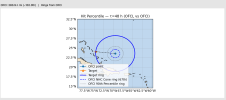
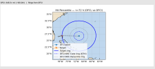
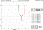
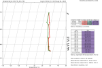
ATCF updated and now Erin is at 130 kts (150 mph) with a pressure of 934 mb.
Navigation
Install the app
How to install the app on iOS
Follow along with the video below to see how to install our site as a web app on your home screen.
Note: This feature may not be available in some browsers.
More options
-
Welcome to TalkWeather! We see you lurking around TalkWeather! Take the extra step and join us today to view attachments, see less ads and maybe even join the discussion. CLICK TO JOIN TALKWEATHER
You are using an out of date browser. It may not display this or other websites correctly.
You should upgrade or use an alternative browser.
You should upgrade or use an alternative browser.
Hurricane Erin
- Thread starter wx_guy
- Start date
And it’s rare occasion where a name becomes a MH more than once without retirement.Holy excrement it's already a major hurricane. 120 MPH. Forecast peak up to 150 MPH.
For some statistics nerdery, this is the first major hurricane named with a female name on List 5 since Michelle in 2001. A 24 year gap.
Erin was a Category 3 in 2001, so this current iteration of Erin is the strongest one seen ever.
tornado examiner
Member
That was unexpected
- Thread starter
- #144
wx_guy
Member
- Messages
- 1,202
- Reaction score
- 4,315
- Location
- United States
- HAM Callsign
- KO4ZGH
- Special Affiliations
- SKYWARN® Volunteer
- ARRL Member
I went to bed at the wrong time...always! *cries*
Seriously, though, I'm fully expecting when the two planes intersect the center again, we could be looking at a Cat 5.
Seriously, though, I'm fully expecting when the two planes intersect the center again, we could be looking at a Cat 5.
- Thread starter
- #146
wx_guy
Member
- Messages
- 1,202
- Reaction score
- 4,315
- Location
- United States
- HAM Callsign
- KO4ZGH
- Special Affiliations
- SKYWARN® Volunteer
- ARRL Member
FL Winds at 165 mph. We'll see if they got a dropsonde into it.
- Thread starter
- #147
wx_guy
Member
- Messages
- 1,202
- Reaction score
- 4,315
- Location
- United States
- HAM Callsign
- KO4ZGH
- Special Affiliations
- SKYWARN® Volunteer
- ARRL Member
It's outside of the forecast Cone from 5 AM.This thing is also moving nearly due west, just north of due west.
Think this could reach the Bahamas? I feel like it could. The east coast definitely should watch this closely due to how far west it is getting.It's outside of the forecast Cone from 5 AM.
- Thread starter
- #149
wx_guy
Member
- Messages
- 1,202
- Reaction score
- 4,315
- Location
- United States
- HAM Callsign
- KO4ZGH
- Special Affiliations
- SKYWARN® Volunteer
- ARRL Member
- Thread starter
- #150
wx_guy
Member
- Messages
- 1,202
- Reaction score
- 4,315
- Location
- United States
- HAM Callsign
- KO4ZGH
- Special Affiliations
- SKYWARN® Volunteer
- ARRL Member
- Thread starter
- #151
wx_guy
Member
- Messages
- 1,202
- Reaction score
- 4,315
- Location
- United States
- HAM Callsign
- KO4ZGH
- Special Affiliations
- SKYWARN® Volunteer
- ARRL Member
- Thread starter
- #152
wx_guy
Member
- Messages
- 1,202
- Reaction score
- 4,315
- Location
- United States
- HAM Callsign
- KO4ZGH
- Special Affiliations
- SKYWARN® Volunteer
- ARRL Member
- Thread starter
- #154
wx_guy
Member
- Messages
- 1,202
- Reaction score
- 4,315
- Location
- United States
- HAM Callsign
- KO4ZGH
- Special Affiliations
- SKYWARN® Volunteer
- ARRL Member
True, let's just hope not as far west as the ICON.I guess maybe the ICON model was onto something after all for once.
It's about 30 minutes before either plane hits the center again, so I'm betting it will be a bonified Cat 5 by that point.
So at the rate Erin is intensifying it could hit sub-900 mbs in just a few hours barring another surprise shear or SAL or an EWRC.True, let's just hope not as far west as the ICON.
It's about 30 minutes before either plane hits the center again, so I'm betting it will be a bonified Cat 5 by that point.
majorhurricane1703
Member
The thing that is the biggest thing at this point (if there was something to question at all) is that northeast ridge in particular modeling the strength effectively at the mid levels. It may be that the storm is being influenced by its’ mid level flow which could be very well stronger than advertised. I’m not totally convinced yet that ridge in the northeast Atlantic is going to just totally collapse. Even on X this morning it was mentioned that west to south west motion was too long for it to just be considered a typical wobble.
It is still continuing westwards. It also is south of the current cone too. That to me is very concerning for the future trajectory of this thing.The thing that is the biggest thing at this point (if there was something to question at all) is that northeast ridge in particular modeling that effectively at the mid levels. It may be that the storm is being influenced by its’ mid level flow which could be very well stronger than advertised. I’m not totally convinced yet that ridge in the northeast Atlantic is going to just totally collapse.
- Thread starter
- #158
wx_guy
Member
- Messages
- 1,202
- Reaction score
- 4,315
- Location
- United States
- HAM Callsign
- KO4ZGH
- Special Affiliations
- SKYWARN® Volunteer
- ARRL Member
majorhurricane1703
Member
Well remember also before it reached north of the islands it was delaying moving west northwest for 24 hours. I highly doubt that happens in this case, but it can’t be discounted either.It is still continuing westwards. It also is south of the current cone too. That to me is very concerning for the future trajectory of this thing.
- Thread starter
- #160
wx_guy
Member
- Messages
- 1,202
- Reaction score
- 4,315
- Location
- United States
- HAM Callsign
- KO4ZGH
- Special Affiliations
- SKYWARN® Volunteer
- ARRL Member
Recon just found 919 mb extrapolated down to 917 mb, with flight-level winds of 180 mph. Pretty sure this is a Cat 5.

