• Welcome to TalkWeather!
    We see you lurking around TalkWeather! Take the extra step and join us today to view attachments, see less ads and maybe even join the discussion.
    CLICK TO JOIN TALKWEATHER

Enhanced Fujita Ratings Debate Thread

Next year will mark 30 years since Wisconsin last had a definitely violent tornado! Out of conventionally tornado-prone states, I believe only Michigan has a longer streak. (Massachusetts and New York have more recent ones although both were probably wrongly rated EF3)
The New York one, if indeed it is the one I'm thinking of (Smithfield 2014), was not rated EF3 but rather EF2. This entailed going below LB for the DI where the most extensive damage occurred.
 
Do y'all think the April 27, 2011 Cordova EF4 ever reached EF5 intensity? None of the damage indicates an EF5 tornado, but iirc the same supercell produced at least one EF5 tornado and the long track makes me believe there's a chance it was over 200 mph at some location.
 
Do y'all think the April 27, 2011 Cordova EF4 ever reached EF5 intensity? None of the damage indicates an EF5 tornado, but iirc the same supercell produced at least one EF5 tornado and the long track makes me believe there's a chance it was over 200 mph at some location.

I think there's a good chance it did over rural areas of northeastern Pickens County to where it hugged the Tuscaloosa/Fayette County line and into southwestern Walker County, but there was nothing there to indicate it. However the radar signatures (reflectivity and velocity) were absolutely insane, even more impressive than Tuscaloosa. James Spann and Jason Simpson were practically incredulous over the numbers their weather computer's algorithm was spitting out based off it.
 
Do y'all think the April 27, 2011 Cordova EF4 ever reached EF5 intensity? None of the damage indicates an EF5 tornado, but iirc the same supercell produced at least one EF5 tornado and the long track makes me believe there's a chance it was over 200 mph at some location.
I absolutely believe that Cordova reached EF5 intensity, just didn’t deserve the rating based on pretty much any interpretation of the EF scale.

Given the context of the super outbreak parameters that day, it’s really hard for me to believe that a tornado that was on the ground for 127 miles continuously, being violent for a significant portion of it, and didn’t reach EF5 intensity at any point in its life. Especially when the computers spit out a 17.5 STP value for the supercell while it was producing the Cordova tornado. Also, like you mentioned, the supercell produced 2 EF5s and 2 EF4s by itself throughout its life. Absolutely ludicrous.

On 4/27/11, I wouldn’t be surprised in the slightest if over 10 tornadoes reached EF5 intensity at at least one point in their lives. The slam-dunks are the ones that were either rated EF5 or were controversial EF4s (Tuscaloosa, Ringgold, Flat Rock) and the ones that could have reached EF5 were ones like Cordova or the Tennessee HE EF4.
 
Do y'all think the April 27, 2011 Cordova EF4 ever reached EF5 intensity? None of the damage indicates an EF5 tornado, but iirc the same supercell produced at least one EF5 tornado and the long track makes me believe there's a chance it was over 200 mph at some location.
100%.

A lot of the attention from that day goes to the Tuscaloosa supercell and rightfully so, but the Cordova supercell was the supercell of the day in my opinion. The incipient stage of the cell actually merged with the ongoing supercell that had already dropped the Philadelphia, MS EF5 before it crossed the Alabama line. Then shortly after crossing into Alabama it dropped the aforementioned Cordova EF4. Then throughout its life it would drop the Rainsville EF5, the Ringgold EF4, an EF3 in northeastern Tennessee, and finally a few weaker tornados in southwestern Virginia. I’m sure it also dropped some weaker tornados in the rural, mountainous areas of eastern Tennessee.

Now, in the confines of the scale, there is nothing controversial over the Cordova rating. However, as @CheeselandSkies and @slenker mentioned, the environment it was operating in was legitimately as maxed out as you’ll see. As Spann and Simpson watched the storm, it went from an area of a 15.3 STP to an area of 17.5! Which was legitimately mind blowing to both of them. Keep in mind, it’s one thing to see models spit out those values in la la land 3 days before an event, or to see it in a completely capped off plains environment. It’s another to see it actually observed with a fully mature, discrete supercell operating within it. So I completely believe at multiple times in its lifecycle it hit 200+.

Here is a graphic of the evolution of each supercell in NWS Jackson’s area that they posted on their site from that day. Due to the extreme parameter space, look at just how fast the newly born Cordova cell merged with the Philadelphia cell and proceeded to drop a tornado. In the span of ten minutes, merger and all, it developed a perfect shape and dropped a 115+ mile tornado.
 

Attachments

  • IMG_8105.jpeg
    IMG_8105.jpeg
    473.7 KB · Views: 0
100%.

A lot of the attention from that day goes to the Tuscaloosa supercell and rightfully so, but the Cordova supercell was the supercell of the day in my opinion. The incipient stage of the cell actually merged with the ongoing supercell that had already dropped the Philadelphia, MS EF5 before it crossed the Alabama line. Then shortly after crossing into Alabama it dropped the aforementioned Cordova EF4. Then throughout its life it would drop the Rainsville EF5, the Ringgold EF4, an EF3 in northeastern Tennessee, and finally a few weaker tornados in southwestern Virginia. I’m sure it also dropped some weaker tornados in the rural, mountainous areas of eastern Tennessee.

Now, in the confines of the scale, there is nothing controversial over the Cordova rating. However, as @CheeselandSkies and @slenker mentioned, the environment it was operating in was legitimately as maxed out as you’ll see. As Spann and Simpson watched the storm, it went from an area of a 15.3 STP to an area of 17.5! Which was legitimately mind blowing to both of them. Keep in mind, it’s one thing to see models spit out those values in la la land 3 days before an event, or to see it in a completely capped off plains environment. It’s another to see it actually observed with a fully mature, discrete supercell operating within it. So I completely believe at multiple times in its lifecycle it hit 200+.

Here is a graphic of the evolution of each supercell in NWS Jackson’s area that they posted on their site from that day. Due to the extreme parameter space, look at just how fast the newly born Cordova cell merged with the Philadelphia cell and proceeded to drop a tornado. In the span of ten minutes, merger and all, it developed a perfect shape and dropped a 115+ mile tornado.

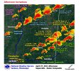
I'm not sure if those values represented the STP or "significant tornado parameter" as we think of it in the forecasting/parameter space diagnostic tool sense. The term they used was "significant tornado index" which I took to mean some sort of algorithm used by their weather software (not sure what they were using at the time, my station uses The Weather Company's MAX Studio) to assess the storm based off the radar signature (in addition to the "significant tornado index," it also spits out a "tornado impact" number, no idea what the difference is between the two or how they relate to each other).

In any case, numbers like that mean, essentially, "s*** is hitting the fan."
I’m pretty sure I read on here a post from Fred where he was stating that specific index, the significant tornado index, was basically just what their software was calling STP. I’ll see if I can find it. However, I’ve personally seen some RAP reanalysis soundings from the Cordova area that day, and the STP was reaching up and a little over 17.


I’m having trouble quoting on mobile, but here is the post:

An interesting tidbit about that Significant Tornado Index in their radar software from back then... We didn't realize it at the time, but instead of that being WSI's equivalent of the Baron Tornado Index and just a 1-10 ranking, that was just their point-readout of the STP and WSI used the word "Index" instead of "Parameter". It was just a readout of mesoscale analysis data at the location of the SCIT in the radar data, similar to the CAPE, SRH, etc., that was also listed in those marquee boxes when they came up. This explains why the "Significant Tornado Index" was as high as 15-17.5 later in the coverage... because mesoanalysis STP values ended up running that high in west central Alabama that afternoon. The "Tornado Impact" number is their answer to the Baron Tornado Index (BTI) and does run 0-10 or 1-10 like the BTI does.

Post in thread 'Discussion of April 27, 2011 Outbreak'
https://talkweather.com/threads/discussion-of-april-27-2011-outbreak.421/post-74530
 
Do y'all think the April 27, 2011 Cordova EF4 ever reached EF5 intensity? None of the damage indicates an EF5 tornado, but iirc the same supercell produced at least one EF5 tornado and the long track makes me believe there's a chance it was over 200 mph at some location.
Actually, @TH2002 found an (unsurveyed) plausibly well-built house in Cullman County which he considered EF5 damage. He mentioned it in a post a while back:
Cordova: a newly built, plausibly well constructed home was swept away in Cullman County that was missed in the survey. That, plus the contextual damage is enough for EF5 imo.
 
Actually, @TH2002 found an (unsurveyed) plausibly well-built house in Cullman County which he considered EF5 damage. He mentioned it in a post a while back:
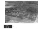
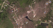
Yup. This home specifically:
cordova-damage-home-aerial-jpg.14930


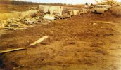
This photo speaks for itself. I believe it was also taken in Cullman County, but not 100% sure:
cordova-ef5-damage-scouring-jpg.14926
 
Yup. This home specifically:
-pic

This photo speaks for itself. I believe it was also taken in Cullman County, but not 100% sure:
-pic
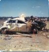
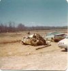
The first image is the first damage photo I’ve seen of Cordova that shows a slab. Every other image I’ve seen is the two images of the patchy Philadelphia-like scouring (which to me really didn’t seem overly impressive) and of the crater left behind by a semi impacting the ground (which is still an extremely impressive image to me by itself) (also I could be mixing this up with another tornado)

I’m really astounded at how violent that bottom image is - any time I see that 1-2 punch of prominent and very clear grass scouring coinciding with tree damage of that caliber, I don’t think it is that unreasonable to automatically assume EF5 intensity there.
 
Last edited:
Back
Top