Day 2 Convective Outlook
NWS Storm Prediction Center Norman OK
1220 PM CDT Thu May 15 2025
Valid 161200Z - 171200Z
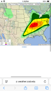
...THERE IS A MODERATE RISK OF SEVERE THUNDERSTORMS ACROSS PARTS OF
SOUTHEAST MISSOURI...SOUTHERN ILLINOIS/INDIANA...AND CENTRAL AND
WESTERN KENTUCKY...
...SUMMARY...
A regional outbreak of severe thunderstorms is likely across parts
of the middle Mississippi and Ohio Valleys Friday afternoon into
Friday night. This may include a few intense supercells posing a
risk for large hail and tornadoes. During the evening into the
overnight hours, this will include an upscale growing and organizing
bowing line of storms posing a risk for strong, damaging winds and a
continuing risk for tornadoes.
...A regional outbreak of severe storms is expected on Friday across
portions of the Mid-South to the Ohio Valley...
...Synopsis...
An upper cyclone over the Upper Midwest and attendant shortwave
trough will develop east/northeast across much of the Midwest and TN
Valley. A swath of strong mid/upper southwesterly flow will
accompany this system. Forecast guidance shows a 70-90 kt 500 mb jet
spreading across the Mid-MS to OH Valley, while 850-700 mb increases
to 40-60 kt by midday. This will result in supercell wind profiles,
support widespread organized convection. Favorable deep-layer shear
will extend downstream into the central Appalachians and
Mid-Atlantic vicinity as well.
At the surface, low pressure will shift east from northern MN into
the Upper Great Lakes. A warm from southern MO into the OH Valley
Friday morning is forecast to lift northward through the afternoon,
allowing rich boundary layer moisture (mid/upper 60s F dewpoints) to
overspread much of the Lower OH Valley, with a large warm sector in
place across a broad region from east TX to the Great Lakes and
eastward toward the Mid-Atlantic coast. Corridors of moderate to
strong destabilization during the day and into the nighttime hours
will support several areas of severe storms from east Texas into
much of the Midwest and the Mid-Atlantic, some of which could be
significant.
...Mid-MS Valley into the OH/TN Valley Vicinity...
Forecast guidance depicts potential for remnant convection from Day
1/Thu ongoing across KY or TN Friday morning. Current expectation is
that this activity will dissipate or weaken as it shifts east toward
the central Appalachians. Strong warm advection should allow for
rapid airmass recovery in the way of any morning thunderstorm
activity.
By midday, a very moist (mid 60s to low 70s F dewpoints) airmass
will be in place beneath steep midlevel lapse rates, fostering
MLCAPE around 2500-3500 J/kg from southeast MO northward to around
the I-70 corridor and east toward the IN/KY. One or more clusters of
convection is expected to develop by early afternoon within the
strong warm advection regime and as large-scale ascent increases
with the approach of the upper trough and an eastward-advancing cold
front extending from eastern IA/western MO into central OK/TX around
midday.
Supercell wind profiles with enlarged low-level hodographs becoming
elongated above 2-3 km within a volatile thermodynamic environment
suggests convection will rapidly intensify. Any convection that
remains discrete will pose a risk for very large hail (up to 3.5
inches), tornadoes (a few may be strong), and damaging gusts. With
time, consolidation of thunderstorm clusters is expected and an
organized bow is forecast to move across the OH/TN Valley region.
Intense, damaging gusts greater than 70 kt will be possible once
this occurs.
Additional convection is expected to develop during the evening
ahead of the advancing cold front from northern AR into western
TN/KY. If this activity can remain discrete, supercells will pose an
all-hazards severe risk. Eventually, this activity should become
linear, but will still have an attendant wind/tornado risk, with a
gradual weakening trend during the overnight hours expected across
MS/AL/GA.
...Central Appalachians to Mid-Atlantic...
Thunderstorms may be ongoing Friday morning across parts of PA and
spread east/southeast through early afternoon as a lead upper
shortwave impulse moves across the Northeast. Moistening and heating
ahead of this activity will support moderate to strong
destabilization, especially from the Chesapeake Bay vicinity
southward across the VA/NC Piedmont. The initial round of
thunderstorms may pose a risk for locally strong gusts and hail
before moving offshore the NJ/DE/MD coast during the early
afternoon.
During the evening/overnight hours, a mature bowing MCS is expected
to move over the WV/VA/NC mountains and spread east across the
region, posing a risk for swaths of strong to damaging wind gusts.
Forecast guidance varies in timing and exact evolution of this
system across the region, but portions of the area may need higher
probabilities in subsequent outlooks.
...WI/MI...
Thunderstorms are expected to develop ahead of the surface low and
cold front during the afternoon and evening. Cold temperatures aloft
will support steep midlevel lapse rates and weak to moderate
instability despite more modest boundary layer moisture. Favorable
shear will support organized convection capable of isolated damaging
gusts and hail.
...ArkLaTex vicinity...
A more conditional risk of significant severe thunderstorms will
exist across northeast TX into southern AR/northwest LA. A very
moist and strongly unstable airmass will be in place, and forecast
guidance suggests capping should erode along/ahead of the surface
dryline. Low-level convergence along the surface boundary is not
expected to be strong, and large-scale ascent will be nebulous, with
neutral height tendencies expected. Nevertheless, at least a few
storms are expected to develop during/just after peak heating.
Supercell wind profiles, with long/straight hodographs are apparent
in forecast soundings. Furthermore, thermodynamic profiles will be
very favorable for large hail, while steepening low-level lapse
rates will support strong outflow winds. Isolated significant hail
(to 2.5 inches) is possible in addition to sporadic damaging gusts.
..Leitman.. 05/15/2025