Navigation
Install the app
How to install the app on iOS
Follow along with the video below to see how to install our site as a web app on your home screen.
Note: This feature may not be available in some browsers.
More options
-
Welcome to TalkWeather! We see you lurking around TalkWeather! Take the extra step and join us today to view attachments, see less ads and maybe even join the discussion. CLICK TO JOIN TALKWEATHER
You are using an out of date browser. It may not display this or other websites correctly.
You should upgrade or use an alternative browser.
You should upgrade or use an alternative browser.
Severe WX Severe Weather Threat 4/6-4/7/18
- Thread starter Taylor Campbell
- Start date
rolltide_130
Member
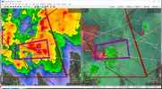
Looking as far back as Radarscope will let me on the Texas tornado warned storm SE of Lampasas, WOW. Classic signature of a significant tornado for a while. Headed awfully close to Florence, TX, still with some rotation. I was not expecting significant tornadoes to perhaps be the big story today.
This came out of nowhere. Somewhat of a concerning trend for the rest of the month as the pattern heats up as you can usually tell what the general trend will be (over or underperformers consistently) fairly early on..
CheeselandSkies
Member
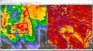
Damage reports coming in via KSLA.
From that live shot they had, looks like it hit or at least brushed the Shell station at Armistead. Extrapolating an ESE motion from there, it likely missed Coushatta proper to the south, but may have clipped some of the neighborhoods on the south side of town. In fact, their website reports an entrapment rescue at a home on Postell Road in one of those developments due to a tree down on the house.
- Admin
- #44
- Messages
- 3,609
- Reaction score
- 3,415
- Location
- Fayetteville, AR
- Special Affiliations
- SKYWARN® Volunteer
March of the storm warnings...

Xtreme Weather
Member
Loop of the storms last night
http://rammb.cira.colostate.edu/ram...ber_of_images_to_display=100&loop_speed_ms=50
http://rammb.cira.colostate.edu/ram...ber_of_images_to_display=100&loop_speed_ms=50
Loop of the storms last night
http://rammb.cira.colostate.edu/ram...ber_of_images_to_display=100&loop_speed_ms=50
Is it just me, or does it look like those overshooting tops are rotating?
Kory
Member
NWS New Orleans is sending survey crews out to Washington, St. James, St. Charles, and Jefferson to survey potential tornado damage. NOLA metro experienced widespread 50-60 mph winds this morning.
- Moderator
- #48
I was thinking the same thing. Such remarkable imagery.Is it just me, or does it look like those overshooting tops are rotating?
Xtreme Weather
Member
It appears to be the caseIs it just me, or does it look like those overshooting tops are rotating?
Edit NWS survey out from SHV
NOUS44 KSHV 072316
PNSSHV
ARZ050-051-059>061-070>073-LAZ001>006-010>014-017>022-OKZ077-
TXZ096-097-108>112-124>126-136>138-149>153-165>167-081130-
Public Information Statement
National Weather Service Shreveport La
616 PM CDT Sat Apr 7 2018
...NWS Damage Survey For April 6, 2018, Tornado Event...
.Tornado in DeSoto and Red River Parishes...
Rating: EF-2
Estimated Peak Wind: 125 MPH
Path Length /Statute/: 10.26 Miles
Path Width /Maximum/: 1800 Yards
Fatalities: 0
Injuries: 0
Start Date: 04/06/2018
Start Time: 07:31 PM CDT
Start Location: 8 miles W of Coushatta / DeSoto Parish, LA
Start Lat/Lon: 32.0137 / -93.4824
End Date: 04/06/2018
End Time: 08:02 PM CDT
End Location: 2 miles ESE of Coushatta / Red River Parish, LA
End_Lat/Lon: 32.0126 / -93.3101
Survey Summary: A tornado touched down along Highway 510 in eastern DeSoto
Parish near the Wemple community where it caused minor tree damage. It then
continued east across Bayou Pierre and produced significant tree damage with
numerous uprooted and snapped trees along and near Highway 177. It also snapped
a few utility poles and did significant damage to a large metal structure where
it buckled the support beams as it crossed Highway 177. It continued east where
it paralleled Highway 371 and snapped numerous trees. The tornado was at its
strongest and widest as it crossed Highway 84 near the Armistead community.
It destroyed a metal building and a few smaller metal structures along with
snapping numerous utility poles. It continued to parallel Highway 84 east
where it destroyed several more metal outbuildings, a farm irrigation system,
and snapped more utility poles. It caused more tree damage and snapped more
utility poles along Riverfront Road before it crossed the Red River. It moved
more east southeast where it crossed Clark Street causing more significant
tree damage and lifting a large metal framed carport and barn at a home here.
The tornado continued moving east where it crossed Highway 480 before causing
more widespread tree damage along Postell, Springville, and Newton Roads. The
tornado then turned slightly northeast before lifting near the intersection of
Bruce Street and Highway 71 where it snapped and uprooted several more trees.
Last edited:
CheeselandSkies
Member
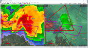
Based on its radar signature, that was likely the most intense tornado of the year to date. Would have leveled Coushatta had it gone right through town at peak strength, so the TORE was well warranted.
Of course it was closer to the radar than Jacksonville, AL, so it may not be a fair comparison.
Of course it was closer to the radar than Jacksonville, AL, so it may not be a fair comparison.