tornado examiner
Member
That new perryville EF3 is a DAT mistake. Paducah public site lists it as EF2 135mph.Actually it is 40 EF2+ tornadoes. 27 EF2’S, 10 EF3’S, and 3 EF4’S.
Follow along with the video below to see how to install our site as a web app on your home screen.
Note: This feature may not be available in some browsers.
That new perryville EF3 is a DAT mistake. Paducah public site lists it as EF2 135mph.Actually it is 40 EF2+ tornadoes. 27 EF2’S, 10 EF3’S, and 3 EF4’S.
It truly was one for the books. Gonna be interesting to see the final tally.27Ef2/10Ef3/3Ef4, which is up to 40 significant tornadoes and counting.
The total count is closing in on 100 at 94+.
This tornado outbreak is a verified high risk hook, line, and sinker.
4 of those tornadoes were on the ground for 50+ miles.27Ef2/10Ef3/3Ef4, which is up to 40 significant tornadoes and counting.
The total count is closing in on 100 at 94+.
This tornado outbreak is a verified high risk hook, line, and sinker.
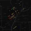
I think it’s likely that a lot of the tornado surveying isn’t complete yet and probably won’t be for another couple of days to a week.Perhaps the Bakersfield survey hasn’t been completed on the public DAT…but is actually much better if this image is anything to go by. A Little Rock meteorologist uploaded this pic to twitter which was likely taken from the actual NWS DAT EDITOR.
The Bakersfield track is noticeably longer here than on the public version.
I think.
Yes I’m scrounging because I really desperately hope the Bakersfield survey doesn’t stay the way it is on the public DAT because it would make nws Springfield a laughing stock…
Indeed…but it is imo highly silly to upload such a half baked and unfinished survey to the public even if it’s preliminary. With wording that suggests that its path was finalized and inaccurate DI’s.I think it’s likely that a lot of the tornado surveying isn’t complete yet and probably won’t be for another couple of days to a week.
Now that I agree with. Low end EF3 is far too low for this tornado. Construction was iffy throughout the path of this tornado from what i’ve seen though, but contextual damage easily warrants a rating higher than a low end EF3.Indeed…but it is imo highly silly to upload such a half baked and unfinished survey to the public even if it’s preliminary. With wording that suggests that its path was finalized and inaccurate DI’s.
Bakersfield now upgred to 155mph. Still too low obviously.Now that I agree with. Low end EF3 is far too low for this tornado. Construction was iffy throughout the path of this tornado from what i’ve seen though, but contextual damage easily warrants a rating higher than a low end EF3.


At least it still says preliminary.Bakersfield now upgred to 155mph. Still too low obviously.
At least it still says preliminary.
And here’s another video of it for y’all BTW
Very thankful that didn’t come into play. That would’ve been a nightmare scenario.One thing I noticed over the last couple days looking at maps of northeast Arkansas is that a lot of the major highways - and consequently, population centers, are oriented in a SW-NE fashion, almost exactly parallel to the tracks of the supercells from last Friday night (or actually most tornado outbreaks in general, but they seemed particularly aligned to this one).
AR-367 (which the Diaz tornado went almost right up), AR-25, US 49, I-57 and others. With a little worse luck, one of those cells could have produced a long-track, violent tornado that went right through Jonesboro, Paragould to Marmaduke, and the Diaz path might have extended from, say, Searcy to Walnut Ridge.
And this is simply my opinion, but if the Bakersfield tornado stays at ef3, it will definitely be an example of a damage survey underestimation.
I keep going back to these Facebook pictures which show blatant Ef4 contextual damage. The surveyors who rated Rolling Fork put Ef4 DIs for the trees. I’m sure the same can be done here.
And this is simply my opinion, but if the Bakersfield tornado stays at ef3, it will definitely be an example of a damage survey underestimation.
I keep going back to these Facebook pictures which show blatant Ef4 contextual damage. The NWS Jackson surveyors who rated Rolling Fork put Ef4 DIs for the trees. I’m sure NWS Springfield can do the same here.