• Welcome to TalkWeather!
    We see you lurking around TalkWeather! Take the extra step and join us today to view attachments, see less ads and maybe even join the discussion.
    CLICK TO JOIN TALKWEATHER

2025 Global Tropical Cyclone Season Discussion

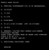
Dvorak has risen to T#3.5 on Tropical Cyclone 21P.

3.5 is 55 kts (65 mph), where earlier 2.5 was 35 kts (40 mph) but the JTWC went 40 kts (45 mph)

I expect by 00-06Z for 21P’s intensity to be raised to 50 kts (60 mph)
——————————————-
All other Satellite Fix Bulletins for the other systems:

IMG_4745.jpeg
IMG_4746.jpeg
IMG_4747.jpeg
 

Attachments

  • IMG_4744.jpeg
    IMG_4744.jpeg
    269.7 KB · Views: 0
Here is near realtime images of all tropical cyclones or disturbances around the SHEM. (For once, I don’t have to label every image with it’s corresponding storm as the storm name is already there)
IMG_4748.png
IMG_4749.png
IMG_4750.png
IMG_4751.png
IMG_4752.png
IMG_4753.png
 
And finally for now, good morning Bianca!

IMG_4754.jpeg
 
Good morning and welcome to yet another TC!

Invest 97S has become Moderate Tropical Storm Garance (JTWC designation 22S)

Tropical Cyclone GARANCE
As of 12:00 UTC Feb 25, 2025:

Location: 18.3°S 51.9°E
Maximum Winds: 35 kt Gusts: N/A
Minimum Central Pressure: 1001 mb
Environmental Pressure: N/A
Radius of Circulation: N/A
Radius of Maximum wind: 90 nm
34 kt Wind Radii by Quadrant:
 
And overnight 21P was named Seru by the Fiji Met Service. With Garnace's formation, we now have 5 concurrent TCs active across the SHEM! That is a very rare occurance indeed.

18P Alfred
19P Rae
20S Bianca
21P Seru
22S Garance
 
And overnight 21P was named Seru by the Fiji Met Service. With Garnace's formation, we now have 5 concurrent TCs active across the SHEM! That is a very rare occurance indeed.

18P Alfred
19P Rae
20S Bianca
21P Seru
22S Garance
If Invest 95S in the Mozambique Channel (Which is also a high chance invest now with a TCFA) forms, we will have 6 TCs at once.
 
This is where we are at now in designations:

2024-25
01S Ancha
02S Bheki
03S Robyn
04S Chido
05S Five
06P Six
07S Dikeledi
08P Pita
09S Nine
10S Sean
11S Faida
12S Elvis
13S Vince
14S Taliah
15P Fifteen
16P Sixteen
17S Zelia
18P Alfred
19P Rae
20S Bianca
21P Seru
22S Garance
 
Invest 95S is now Moderate Tropical Storm 23S! We now have SIX TROPICAL CYCLONES active at once across the SHEM!

Tropical Cyclone TWENTYTHREE
As of 18:00 UTC Feb 25, 2025:

Location: 22.7°S 38.1°E
Maximum Winds: 35 kt Gusts: N/A
Minimum Central Pressure: 995 mb
Environmental Pressure: N/A
Radius of Circulation: N/A
Radius of Maximum wind: N/A
 
And along with that, we now have 2 TCs active in all three SHEM basins!

Rae and Seru in the South Pacific
Alfred and Bianca in the Australian Region
Garnace and newly-formed 23S in the South-West Indian Ocean.

This may be the first time in many years to have a named storm active in all three basins, let alone being very close to having TWO named cyclones active in every SHEM basin.
 
Saving this map as a screenshot for historical purposes.

Screenshot 2025-02-25 2.59.37 PM.png
Six red areas (95S has not updated with the first warning as its new designation of 23S)

Tuesday, February 25th, 2025, 3:02 PM EST
 
23S warning graphic!

Screenshot 2025-02-25 3.44.47 PM.png
 
23S is now Moderate Tropical Storm Honde!

Garance is now expected to peak at 100 kts (115 mph) now too.

Garnance's current inensity is 60 kts (70 mph), just shy of hurricane-equivelent status. Honde is at 50 kts (60 mph) now.

Alfred is still at 75 kts (85 mph) as of now and Bianca is on its way out, having fallen below hurricane-force.
 
Don't know when we will see this on the JTWC homepage map again, so I am saving it and putting it here:


Screenshot 2025-02-26 9.46.21 AM.png
All six tropical cyclones now have a name.
 

Attachments

  • 1740581286583.png
    1740581286583.png
    1 MB · Views: 0
The last time six tropical cyclones were active at the same time in the SHEM was in 1989, 36 years ago.

Screenshot 2025-02-26 10.08.45 AM.png
 
On the three SPAC storms:

Screenshot 2025-02-26 10.11.54 AM.png
 
In terms of activity by this date (February 26th), the 2024-25 SHEM season is now a part of a three-way tie for the fifth-most TCs in the SHEM at this date. The 2024-25 season has produced the fifth most amount of tropical cyclones by this date in data going back to 1975.


1996-97 = 30
1983-84, 1984-85 = 26
1997-98 = 25
1991-92, 1998-99 = 24
1977-78, 2020-21, 2024-25 = 23
1974-75 = 22
 
Last edited:
Garance is rapidly becoming better defined, one might even say it is undergoing RI at this moment.

Screenshot 2025-02-26 12.16.40 PM.png
 
Soon. Probably within 2 days.
@IdaliaHelene

I underestimated Bianca. Bianca has lasted beyond my two day estimation from the comment above. It has lasted three days now, and is likely to turn post-tropical soon, likely later today or tonight.
 
I have updated the OG to include the TC names in the SWIO for the 2025-26 season and have added Jakarta and Port Moresby names for the Australian Region.
 
Back
Top