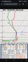
Mesoscale analysis temps/dew points vs modeled dew points. 

Follow along with the video below to see how to install our site as a web app on your home screen.
Note: This feature may not be available in some browsers.

I believe the the FTW snow band is in relation to the 700 mb advection/frontogensis, if anyone cares to take a look at what the hrrr shows that doing tomorrow morning.....i can't post it right now

thats radar reflectivity...but prob shows 700mb frontogensis shifting south...but no doubt there is some lift with that as it passes to the south....

Tds in Birmingham was in low single digits at 6am on the 10th, per 6am sounding.The dewpoints for the January 10th snow were just in the low to mid 20s
Yeah that's exactly what I was looking at earlier. That dry air has a battle on it's hands. Even lower level IR is looking slightly better. Might not be enough however....
Yes that's basically a 700mb front forming...colder air moving south. If you look at the light returns up in okc, they are moving south. It's what will end our snow chances but maybe bring our best chance for central Alabama just before and as it passes through..if it can get here before the high shuts it all down
enough to matter?and the 0z nam has ticked north with the 700mb fronto
no. still 100 miles from a dusting in bhamenough to matter?
yes, soundings look better, and its just one run maybe with some new gulf data...although I don't think that will make alot of difference up here...unless the low shifts dramatically north...or the high isn't as strongenough to matter?
do you think Atlanta will see any snow tomorrow?not as far south as other runs
subtle improvement -not as far south as other runs
12z or 18z?@JPWX can you please post the 50 EURO ensemble members?