
Navigation
Install the app
How to install the app on iOS
Follow along with the video below to see how to install our site as a web app on your home screen.
Note: This feature may not be available in some browsers.
More options
-
Welcome to TalkWeather! We see you lurking around TalkWeather! Take the extra step and join us today to view attachments, see less ads and maybe even join the discussion. CLICK TO JOIN TALKWEATHER
You are using an out of date browser. It may not display this or other websites correctly.
You should upgrade or use an alternative browser.
You should upgrade or use an alternative browser.
Severe Weather Threat 12.26-12.29.2024
- Thread starter JBishopwx
- Start date

Back to radar-indicated. Unique wording used by MOB to address the difficulty in determining whether there is a TOG or not.
...A TORNADO WARNING REMAINS IN EFFECT UNTIL 900 PM CST FOR CENTRAL
MOBILE AND WEST CENTRAL BALDWIN COUNTIES...
At 845 PM CST, A possible tornado is located over Midtown Mobile,
moving east at 30 mph.
HAZARD...Tornado and quarter size hail.
SOURCE...Radar indicated rotation.
IMPACT...Flying debris will be dangerous to those caught without
shelter. Mobile homes will be damaged or destroyed. Damage
to roofs, windows, and vehicles will occur. Tree damage is
likely.
This tornado will be near...
I65 And I165, Chickasaw, Downtown Mobile, and Prichard around 850
PM CST.
Spanish Fort around 905 PM CST.
PRECAUTIONARY/PREPAREDNESS ACTIONS...
TAKE COVER NOW! Move to a basement or an interior room on the lowest
floor of a sturdy building. Avoid windows. If you are outdoors, in a
mobile home, or in a vehicle, move to the closest substantial shelter
and protect yourself from flying debris.
Heavy rainfall may hide this tornado. Do not wait to see or hear the
tornado. TAKE COVER NOW!


All 4 have a UH track right through Monroe County. LOL! Boy
lake.effect
Member
UH tracks on the 0Z runs are scary. I think we see a MOD tomorrow.
KevinH
Member
Moderate covering what cities? What do you think will happen with the enhanced area?UH tracks on the 0Z runs are scary. I think we see a MOD tomorrow.
MMWX
Member
- Messages
- 751
- Reaction score
- 2,465
- Location
- Mississippi State University
- Special Affiliations
- SKYWARN® Volunteer
I'd expect a northward ENH expansion and a MDT over the ArkLaMiss area (where the three states meet).Moderate covering what cities? What do you think will happen with the enhanced area?
Shakespeare 2016
Member
It looks like there are plenty of 70+ temperatures and 65+ dewpoints in that area. Temperatures and dewpoints will certainly not be a problem.I'd expect a northward ENH expansion and a MDT over the ArkLaMiss area (where the three states meet).
Nadocast seeing how wild it can go
slenker
Member
Nadocast seeing how wild it can go
With the uptrends, I can see that verifying as the absolute ceiling of this event. But I think whatever the floor is, is more probable than the ceiling occurring, and the most likely outcome will be somewhere in between
Long day ahead tomorrow. Headed to bed to try to get some sleep beforehand. I hope and pray for no fatalities or significant damage.
MMWX
Member
- Messages
- 751
- Reaction score
- 2,465
- Location
- Mississippi State University
- Special Affiliations
- SKYWARN® Volunteer
MMWX
Member
- Messages
- 751
- Reaction score
- 2,465
- Location
- Mississippi State University
- Special Affiliations
- SKYWARN® Volunteer
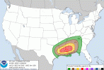
SPC AC 280559
Day 1 Convective Outlook
NWS Storm Prediction Center Norman OK
1159 PM CST Fri Dec 27 2024
Valid 281200Z - 291200Z
...THERE IS A MODERATE RISK OF SEVERE THUNDERSTORMS ACROSS PARTS OF
FAR EAST TEXAS...LOUISIANA...CENTRAL AND SOUTHERN MISSISSIPPI...AND
FAR WESTERN ALABAMA...
...SUMMARY...
An outbreak of severe storms with tornadoes, wind damage, and large
hail is expected today from parts of the southern Plains, eastward
into the lower Mississippi Valley and central Gulf Coast states.
Several long-track strong tornadoes are expected.
...Tornado Outbreak Likely This Afternoon and Evening Across the
Lower Mississippi Valley and Central Gulf Coast States...
A mid-level trough will move quickly eastward across the southern
Plains today, as an associated mid-level jet moves through the base
of the trough. A surface low will deepen across northeast Texas as a
warm front advances northward into the Ark-La-Tex. Scattered
thunderstorms will first develop near the surface low during the
morning, as surface temperatures warm and as large-scale ascent
rapidly increases due to the approaching system. Isolated large hail
will be the initial severe threat across northeast Texas. The exit
region of a 60 to 80 knot mid-level jet will overspread much of east
Texas around midday, where more vigorous thunderstorms are expected
to develop during the early afternoon. These storms will have
potential to produce severe wind gusts, isolated large hail and
tornadoes. A severe MCS appears likely to intensify and organize as
this activity increases in coverage.
Further to the east, an axis of maximized low-level moisture is
expected to be in place during the early afternoon, oriented from
southern Louisiana into western Mississippi. Surface dewpoints along
and near the axis will be in the mid to upper 60s F. The moist axis
will be aligned with a strengthening low-level jet. Scattered
discrete cells are expected to initiate across the undisturbed moist
sector during the afternoon, with several vigorous storms moving
east-northeastward across the central Gulf Coast states. RAP
forecast soundings near the exit region of the mid-level jet, from
central Louisiana into central Mississippi, show steep mid-level
lapse rates around 8 C/km, with 0-6 km shear in the 45 to 55 knot
range. This environment will support supercell development, with a
potential for strong tornadoes, wind damage and isolated large hail.
Forecast soundings in the early to mid afternoon near the low-level
jet from eastern Louisiana into south-central Mississippi show
backed surface winds to the southeast, and increase 0-3 km
storm-relatively helicity to around 300 m2/s2. This should be
favorable for tornadic supercells. The low-level jet is forecast to
move east-northeastward across the central Gulf Coast states in the
mid to late afternoon. Supercells that can tap the higher surface
dewpoints and stay within or near the axis of the low-level jet
should be able to produce long-track EF3+ tornadoes, and several of
these will be possible.
The severe linear MCS further to the west, is expected to move
quickly eastward across the lower Mississippi Valley during the
afternoon, and will likely be accompanied with widespread severe
wind gusts, with potential for gusts above 65 knots along the more
intense part of the line. By early evening, this line of severe
storms is expected to become the dominant feature across the region.
Widespread wind damage is expected along the leading edge of the
line from the central Gulf Coast states into southern parts of the
Tennessee Valley. Tornadoes will be possible with embedded
supercells within the line, and with line echo wave patterns that
form. Due to the fast-moving mid-level trough, large-scale ascent is
expected to support the severe linear MCS from the evening into the
overnight. A potential for wind damage and tornadoes is expected to
continue after midnight as the line moves across middle Tennessee
and Alabama. The MCS with some severe potential, is expected to move
into the southern Appalachians and northern to central Georgia by
the end of the period.
..Broyles/Thornton.. 12/28/2024
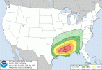
Kds86z
Member
Broyles. I am guessing it would still be moderate given the uptick in trends given he is the more bullish forecaster. Got a bad feeling. Mississippi got lucky this year. I believe Mississippi has the highest fatality rate for tornadoes out of all states. I saw the study.New D1 SPC Outlook. Moderate and 15% hatched added.
Last edited:
Shakespeare 2016
Member
Several long-track EF3+ tornadoes is possible. It definitely sounds concerning.SPC AC 280559
Day 1 Convective Outlook
NWS Storm Prediction Center Norman OK
1159 PM CST Fri Dec 27 2024
Valid 281200Z - 291200Z
...THERE IS A MODERATE RISK OF SEVERE THUNDERSTORMS ACROSS PARTS OF
FAR EAST TEXAS...LOUISIANA...CENTRAL AND SOUTHERN MISSISSIPPI...AND
FAR WESTERN ALABAMA...
...SUMMARY...
An outbreak of severe storms with tornadoes, wind damage, and large
hail is expected today from parts of the southern Plains, eastward
into the lower Mississippi Valley and central Gulf Coast states.
Several long-track strong tornadoes are expected.
...Tornado Outbreak Likely This Afternoon and Evening Across the
Lower Mississippi Valley and Central Gulf Coast States...
A mid-level trough will move quickly eastward across the southern
Plains today, as an associated mid-level jet moves through the base
of the trough. A surface low will deepen across northeast Texas as a
warm front advances northward into the Ark-La-Tex. Scattered
thunderstorms will first develop near the surface low during the
morning, as surface temperatures warm and as large-scale ascent
rapidly increases due to the approaching system. Isolated large hail
will be the initial severe threat across northeast Texas. The exit
region of a 60 to 80 knot mid-level jet will overspread much of east
Texas around midday, where more vigorous thunderstorms are expected
to develop during the early afternoon. These storms will have
potential to produce severe wind gusts, isolated large hail and
tornadoes. A severe MCS appears likely to intensify and organize as
this activity increases in coverage.
Further to the east, an axis of maximized low-level moisture is
expected to be in place during the early afternoon, oriented from
southern Louisiana into western Mississippi. Surface dewpoints along
and near the axis will be in the mid to upper 60s F. The moist axis
will be aligned with a strengthening low-level jet. Scattered
discrete cells are expected to initiate across the undisturbed moist
sector during the afternoon, with several vigorous storms moving
east-northeastward across the central Gulf Coast states. RAP
forecast soundings near the exit region of the mid-level jet, from
central Louisiana into central Mississippi, show steep mid-level
lapse rates around 8 C/km, with 0-6 km shear in the 45 to 55 knot
range. This environment will support supercell development, with a
potential for strong tornadoes, wind damage and isolated large hail.
Forecast soundings in the early to mid afternoon near the low-level
jet from eastern Louisiana into south-central Mississippi show
backed surface winds to the southeast, and increase 0-3 km
storm-relatively helicity to around 300 m2/s2. This should be
favorable for tornadic supercells. The low-level jet is forecast to
move east-northeastward across the central Gulf Coast states in the
mid to late afternoon. Supercells that can tap the higher surface
dewpoints and stay within or near the axis of the low-level jet
should be able to produce long-track EF3+ tornadoes, and several of
these will be possible.
The severe linear MCS further to the west, is expected to move
quickly eastward across the lower Mississippi Valley during the
afternoon, and will likely be accompanied with widespread severe
wind gusts, with potential for gusts above 65 knots along the more
intense part of the line. By early evening, this line of severe
storms is expected to become the dominant feature across the region.
Widespread wind damage is expected along the leading edge of the
line from the central Gulf Coast states into southern parts of the
Tennessee Valley. Tornadoes will be possible with embedded
supercells within the line, and with line echo wave patterns that
form. Due to the fast-moving mid-level trough, large-scale ascent is
expected to support the severe linear MCS from the evening into the
overnight. A potential for wind damage and tornadoes is expected to
continue after midnight as the line moves across middle Tennessee
and Alabama. The MCS with some severe potential, is expected to move
into the southern Appalachians and northern to central Georgia by
the end of the period.
..Broyles/Thornton.. 12/28/2024
TornadoFan
Member
This line got my attention.
"Supercells that can tap the higher surface
dewpoints and stay within or near the axis of the low-level jet
should be able to produce long-track EF3+ tornadoes, and several of
these will be possible."
"Supercells that can tap the higher surface
dewpoints and stay within or near the axis of the low-level jet
should be able to produce long-track EF3+ tornadoes, and several of
these will be possible."
Shakespeare 2016
Member
Mine too!!!!This line got my attention.
"Supercells that can tap the higher surface
dewpoints and stay within or near the axis of the low-level jet
should be able to produce long-track EF3+ tornadoes, and several of
these will be possible."
Bullish outlook - really hope it doesn't verify. Wouldn't be surprised to see northward and eastward expansions to the risk areas later. Threatens to be one of the most significant severe events for the Deep South in recent memory in December. Trey says updated discussion from him coming this morning.

...Tornado Outbreak Likely This Afternoon and Evening Across the
Lower Mississippi Valley and Central Gulf Coast States...
Kds86z
Member
When was the last time this year we saw the words “tornado outbreak “ in a day 1?