CheeselandSkies
Member
Oh boy, now I have to go to the other weather forum for the snow weenie freakout.
Follow along with the video below to see how to install our site as a web app on your home screen.
Note: This feature may not be available in some browsers.
I'm not usually much of a snow weenie, though I wouldn't mind some lately, considering it's either been frigid and rainy or annoyingly muggy, neither of which have been ideal for Christmas time. That being said, Atlanta would probably collapse on itself, so maybe rain and storms are preferable.Oh boy, now I have to go to the other weather forum for the snow weenie freakout.
I love it too but I've given up on it for the most part, it's the ultimate tease in weather! Agree though, it's a lot like forecasting tornadoes, it's a marvel that it *does* happen, not that it doesn't (unless you live in the Yukon I suppose I dunno).I love snow, but forecasting it is a pain in the rear. I use to get so mad when it didn't snow. However, instead of looking at everything going for it to happen, I look at everything going against it happening first. That way I can mentally prepare myself if it fails to happen and the forecast busts. Believe it or not, that helps me a lot.
I wish I could send y'all all of our snow, I'd be fine never seeing it again.I love it too but I've given up on it for the most part, it's the ultimate tease in weather! Agree though, it's a lot like forecasting tornadoes, it's a marvel that it *does* happen, not that it doesn't (unless you live in the Yukon I suppose I dunno).
Oh I don't lol, I ignore them because I have better things to do with my time.Sadly. Genuinely sorry you have to deal with history-deniers as a professional in the field.
Honestly I would accept, personally, but I'm sure most of my neighbors would kill me.I wish I could send y'all all of our snow, I'd be fine never seeing it again.
Mine too. LOL!Honestly I would accept, personally, but I'm sure most of my neighbors would kill me.
We'll have to watch how far separated they remain. If they're too close together, could hinder moisture return on the second system. But broadly speaking, both look like they could bring unsettled weather.We interrupt this program to bring you..... Courage The Cowardly Dog
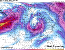
Jokes aside, the 18z GFS presents two opportunities for severe weather going forward. First around the 27th and then the other around the 31st. It looks like the 2nd storm system has a better moisture fetch and dynamics.
Good, I've been jonesing for some Waelti action. "It's gonna fricking hit my hometown. Ah geez, Viccccky".


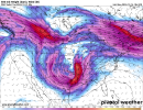
Yep, after a protracted period of unimpressive ejections, the latest run resembles the ones from a few days ago. Really wouldn't be surprised to see it drop off the face of the earth at least once more, but there will probably be something worth keeping an eye on by that time frame. Euro also shows a nice-looking system around the same time.After several runs of a less impressive severe threat with the trough in the 28th-29th timeframe (too squished of a wavelength W-E/becomes negatively tilted too late), today's 12Z GFS raised the ceiling again with the classic broad wavelength/slightly negatively tilted look and corresponding greater surface response/broader warm sector. Something to track, at least.


If I remember correctly, December 10 2021 was the result of a very positively tilted trough. It makes me wonder how the moisture return was so strong for that system - was it already in place before the event unfolded?I wouldn't put too much emphasis on the trough tilt. But regardless we should see a severe weather threat either around Christmas or post Christmas