Tanner
Member
I think that cells will congeal into a line too fast.
Follow along with the video below to see how to install our site as a web app on your home screen.
Note: This feature may not be available in some browsers.
I'm thinking the same thing honestly. There's still gonna be discrete development ahead of it I think, considering the orientation of the current line of storms, but right now there's not much shear to keep them discrete.I think that cells will congeal into a line too fast.
Well.. it’s not over until it’s over.I'm thinking the same thing honestly. There's still gonna be discrete development ahead of it I think, considering the orientation of the current line of storms, but right now there's not much shear to keep them discrete.
Plus 1Yea, those cells aren’t doing jack diddly until the LLJ kicks in and they move into Tennessee/Kentucky.
For sure. I'm not calling anything off, nor am I using the forbidden B word, especially after yesterday.Well.. it’s not over until it’s over.
So trueI think the best phrase appropriate regarding tornado threats in 2024 is (whatever happens happens)
Localized areas in western KY could be primed now. With as many MCSs that have went through KY today, it’s no telling how many boundaries are set upMainly looking at shear in TN later, again we wait for the LLJ to actually ramp up before anything starts being prolific
Is there a way to tell where boundaries are outside of models?Localized areas in western KY could be primed now. With as many MCSs that have went through KY today, it’s no telling how many boundaries are set up
058
WFUS53 KSGF 262206
TORSGF
MOC215-229-262245-
/O.NEW.KSGF.TO.W.0066.240526T2206Z-240526T2245Z/
BULLETIN - EAS ACTIVATION REQUESTED
Tornado Warning
National Weather Service Springfield MO
506 PM CDT Sun May 26 2024
The National Weather Service in Springfield has issued a
* Tornado Warning for...
East central Wright County in southwestern Missouri...
West central Texas County in south central Missouri...
* Until 545 PM CDT.
* At 506 PM CDT, a severe thunderstorm capable of producing a tornado
was located 8 miles northeast of Hartville, or 13 miles northwest
of Mountain Grove, moving east at 40 mph.
HAZARD...Tornado and baseball size hail.
SOURCE...Radar indicated rotation.
IMPACT...Flying debris will be dangerous to those caught without
shelter. Mobile homes will be damaged or destroyed.
Damage to roofs, windows, and vehicles will occur. Tree
damage is likely.
* Locations impacted include...
Houston, Huggins, Bucyrus, Graff, Prescott, and Bendavis.
PRECAUTIONARY/PREPAREDNESS ACTIONS...
TAKE COVER NOW! Move to a basement or an interior room on the lowest
floor of a sturdy building. Avoid windows. If you are outdoors, in a
mobile home, or in a vehicle, move to the closest substantial shelter
and protect yourself from flying debris.
&&
LAT...LON 3727 9240 3735 9240 3746 9191 3724 9191
TIME...MOT...LOC 2206Z 265DEG 36KT 3731 9237
TORNADO...RADAR INDICATED
MAX HAIL SIZE...2.75 IN
$$
Perez
They become more diffuse over time, but early in their life you can see them on radar actually flowing away from the storm causing them.Is there a way to tell where boundaries are outside of models?
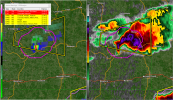
We poppingCell just southwest of St. Louis is tornado warned.
")