
O wow! Pivotal has added a lot since I last lookedHmmmm,...nope. Looks like Euro AIFS (which seems to have replaced the old hi-res Euro on Pivotal) has it, too.
Navigation
Install the app
How to install the app on iOS
Follow along with the video below to see how to install our site as a web app on your home screen.
Note: This feature may not be available in some browsers.
More options
-
Welcome to TalkWeather! We see you lurking around TalkWeather! Take the extra step and join us today to view attachments, see less ads and maybe even join the discussion. CLICK TO JOIN TALKWEATHER
You are using an out of date browser. It may not display this or other websites correctly.
You should upgrade or use an alternative browser.
You should upgrade or use an alternative browser.
Severe Weather 2024
- Thread starter KevinH
- Start date
Mrgolfman7070
Member
The euro AIFS, imo, isn't no better than the regular euro and both are still on tropicaltidbitsO wow! Pivotal has added a lot since I last looked
Looks like most if not all the high res EURO products on Pivitiol have moved to the regular Euro modle tab
CheeselandSkies
Member
Looks like most if not all the high res EURO products on Pivitiol have moved to the regular Euro modle tab
Good to know. That ultra-basic Euro they previously had on the free version was well nigh useless.
MidTNWx
Member
Any recent updates on this system? Does it seem like lack of moisture might be a trend? Too early to tell?
Based on SPC morning discussion, it sounds like the only big hindrance would be cold air infiltration. Other than that, to me, it's all systems go particularly since we know the global models don't do well on moisture return (by that I mean the moisture return is usually robust than the globals show leading up to the event)Any recent updates on this system? Does it seem like lack of moisture might be a trend? Too early to tell?
I'm expecting a 15% risk for severe weather by tomorrow from SPC for next week's threat.
Not this rodeo again! It's deja vu x5I'm expecting a 15% risk for severe weather by tomorrow from SPC for next week's threat.
What's this sneaky setup on Friday?
Dunno but if it ends up as modelled it could cause some problems for the MOB area of jurisdiction.What's this sneaky setup on Friday?
.png")
From SPC:
Within the inland advancing troughing, there appears reasonable
agreement between the ECENS/ECMWF, GEFS and GFS model output that a
significant lead short wave perturbation will accelerate
northeastward out of the Southwest across the southern Rockies late
Sunday into Sunday night. As this occurs, a rather deep cyclone is
forecast to continue to form to the lee of the Front Range during
the day, before migrating southeastward then eastward into the
adjacent high plains. Although it still appears that low-level
moisture return in the wake of prior low-level drying and cooling
across the northern Gulf Basin may still be on the margins for
vigorous thunderstorms, the development of steep
lower/mid-tropospheric lapse rates may compensate. Coupled with
potentially intense wind fields and strong forcing for ascent,
organized severe thunderstorm development seems probable late Sunday
afternoon into Sunday night. This may include supercells initially,
then an evolving narrow squall line.
Into the early through middle portion of next week, uncertainties
concerning a subsequent short wave emerging from the Southwest
increase. However, it appears probable that there will be at least
narrow corridors of strong to severe thunderstorm development on
following days across the southeastern Great Plains into lower
Mississippi Valley and perhaps parts of the Southeast.
From JAN:
Weather turns active again early next week as an upper low/shortwave
eject across the upper plains. In response to the deepening low
pressure system, the mid/low level jet is progged to strengthen,
yielding strong deep shear around 60 kts. Strong low level
directional shear will also yield long curved hodographs, which
favor supercells and may increase tornado potential. However, here`s
the kicker. A low pressure system off the coast of the Carolinas
appears to severely cut the quality of moisture return, as evidenced
by dewpoints hovering in the 58-62 range, and may greatly limit the
severe potential of this system. Even so, should moisture trend
upwards in future guidance, and/or should any storms be able to tap
into a greater quality environment amid a favorable shear profile,
particularly south of I-20. As a result, during this time, there may
be some severe potential for a portion of the area. This event is
still several days away, so expect changes and adjustments as more
data becomes available. In addition to perhaps some severe
potential, will also have to monitor gradient wind potential amid a
5-7 mb pressure gradient over the area, especially Monday into
Tuesday. There are still some uncertainties regarding timing and
evolution of this system as this time, but things should begin to
look clearer as we get closer
From MEG: (searching for instability as always)
Long-term models continue to indicate an unsettled pattern
returning to the area early next week as a deep upper-level trough
moves through the Mississippi Valley. Latest operational model
runs indicate some slight timing and amplitude differences of the
upper-level trough exist with this next system. The operational
ECMWF and Canadian solutions take on more of a negative-tilt as a
mid- level shortwave rotates through the Middle and Lower
Mississippi Valleys. Meanwhile, the operational GFS remains the
slower outlier as the trough is displaced further north across the
Midwest.
Ensemble models are in relative agreement overall and
kept rain chances towards the NBM output for this period. Upper-
level dynamics and kinematics look great with this system.
However, limited instability or the lack thereof will inhibit the
overall strong to severe thunderstorm potential across the Mid-
South. Nonetheless, this potential will continue to be monitored
in subsequent model runs.
tennessee storm chaser
Member
- Messages
- 1,877
- Reaction score
- 4,288
- Location
- jackson tennessee
- Special Affiliations
- SKYWARN® Volunteer
Come on WAKE up severe weather …
Justin Hindman Hindy
Member
This has been the calmest season that I can remember
- Moderator
- #975
Come on WAKE up severe weather …
Be careful what you wish for...
It's funny how everyone expected an active March. As I've been saying, April. April you should be concerned about.
Mrgolfman7070
Member
It's been active up north, but not in our area. At least not lately.It's funny how everyone expected an active March. As I've been saying, April. April you should be concerned about.
akt1985
Member
Speaking of April, I sure hope there are no tornadoes during the total solar eclipse on April 8th.
CheeselandSkies
Member
12Z GFS is suggestive that we could see another sneaky low-dewpoint (by conventional wisdom) severe/tornado threat into the upper Midwest with the long-advertised system next Monday. If not for the equally long-advertised southern stream low that spins up and interdicts the moisture 36-48 hours prior, we could be looking at yet another potentially widespread, high ceiling late March severe weather outbreak.
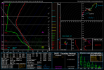
Forecast sounding from near the WI/IL state line, not far from where the February 8th tornadoes occurred. That hodograph looks pretty good, and the moisture depth while not great isn't the worst I've seen. LCL heights would be doable as well if the temperature only gets to around 60.
Forecast sounding from near the WI/IL state line, not far from where the February 8th tornadoes occurred. That hodograph looks pretty good, and the moisture depth while not great isn't the worst I've seen. LCL heights would be doable as well if the temperature only gets to around 60.
Attachments
Austin Dawg
Member
It sounds like the beginning of our hail season starts in the next couple of days. We get those big supercell hailers that you just hope you don't end up in their path. They cause a lot of property damage in this area. there's an outside chance of damaging wind. Very slim chance of tornadoes. It's usually further in the season when we have our chances for tornadoes.