• Welcome to TalkWeather!
    We see you lurking around TalkWeather! Take the extra step and join us today to view attachments, see less ads and maybe even join the discussion.
    CLICK TO JOIN TALKWEATHER

Severe WX Severe Weather Threat - December 8th-10th, 2023

Tornado Warning in MS.
1702178525675.png
BULLETIN - EAS ACTIVATION REQUESTED
Tornado Warning
National Weather Service Jackson MS
920 PM CST Sat Dec 9 2023

The National Weather Service in Jackson has issued a

* Tornado Warning for...
Southeastern Rankin County in central Mississippi...
Northeastern Simpson County in central Mississippi...
West central Smith County in central Mississippi...

* Until 1015 PM CST.

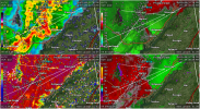
* At 919 PM CST, a severe thunderstorm capable of producing a tornado
was located over Braxton, or 7 miles northwest of Mendenhall,
moving east at 30 mph.

HAZARD...Tornado.

SOURCE...Radar indicated rotation.

IMPACT...Flying debris will be dangerous to those caught without
shelter. Mobile homes will be damaged or destroyed.
Damage to roofs, windows, and vehicles will occur. Tree
damage is likely.

* This dangerous storm will be near...
D'Lo, Puckett, and Cato around 925 PM CST.
Martinville around 930 PM CST.
White Oak around 935 PM CST.
Raleigh around 955 PM CST.

PRECAUTIONARY/PREPAREDNESS ACTIONS...

TAKE COVER NOW! Move to a basement or an interior room on the lowest
floor of a sturdy building. Avoid windows. If you are outdoors, in a
mobile home, or in a vehicle, move to the closest substantial shelter
and protect yourself from flying debris.

&&

LAT...LON 3198 9001 3209 9003 3212 8949 3195 8949
TIME...MOT...LOC 0319Z 265DEG 25KT 3204 8996

TORNADO...RADAR INDICATED
MAX HAIL SIZE...<.75 IN
 
TORR now. Also has second couplet developing north.
1702178754321.png
 
Circulation still sticking around. Transient TDS's apparent at several occasions over the past dozen scans.
1702179412254.png
 
Passing just north of Hollywood, AL.
1702179872518.png
 
If there's one takeaway from this event: Don't discount a threat based on model runs.
 
I'm sure you've been asked before, but for the hell of it - what radar program is that? GR2Analyst if I'm not mistaken?
Affirmative, GR2A. I have a blue-yellow-red palette for reflectivity because I have a hard time seeing greens sometimes. GR2 really helps with providing crisper radar images.
 
Affirmative, GR2A. I have a blue-yellow-red palette for reflectivity because I have a hard time seeing greens sometimes. GR2 really helps with providing crisper radar images.
Cool. Just curious - does KDGX update more often on Level 2 data, or do new scans still only come in every 6 minutes or so?
 
Cool. Just curious - does KDGX update more often on Level 2 data, or do new scans still only come in every 6 minutes or so?
Seems to come in every 2 minutes give or take, but I've seen it vary so don't take it as gospel.
 
BMX's AFD from about an hour ago. They expect the threat to last well into the night as instability and favorable wind profiles will remain.
Area Forecast Discussion
National Weather Service Birmingham AL
916 PM CST Sat Dec 9 2023

...New MESOSCALE UPDATE...

.MESOSCALE UPDATE FOR SEVERE WEATHER THREAT OVERNIGHT...
Issued at 858 PM CST SAT DEC 9 2023

The threat for severe storms and tornadoes continues overnight for
all of Central Alabama. Currently, a line of strong to severe
storms stretches from Chattanooga to Cullman to Columbus MS. Ahead
of the line, a couple clusters of storms have developed, including one
near Demopolis. Counties across the west and far northeast remain
in tornado watches.

Currently, dewpoints are in the 60s areawide, with temperatures in
the mid 60s to lower 70s for much of the area. Looking at the 00Z
ROAB from BMX, surface based CAPE was around 1100J/kg with 45kts
of 0-6km shear. Little to no cap was noted on the sounding.
Current meso analysis shows surface CAPES from 500 to 1000 J/kg
with bulk shear values of 45-55kts ahead of the line. Do not see
much change in airmass over the next few hours, and expect the
Tornado watch to be expanded eastward.


Looking closer to sunrise,the latest CAM guidances shows a surge
of moisture into the southeast after 3AM with a restrengthening
low level jet. This would maintain the severe threat through the
early morning hours across the southeastern counties.
 
Based on preliminary damage reports, that Piney Woods tornado appears to have been on the ground for around 12 miles which seems impressive for a QLCS tornado. And speaking of tornadoes hitting areas that were already hit way too recently, I'd hate to live in Louin right now...
 
Tornado Watch for central AL and parts of GA.
 
Back
Top