
Navigation
Install the app
How to install the app on iOS
Follow along with the video below to see how to install our site as a web app on your home screen.
Note: This feature may not be available in some browsers.
More options
-
Welcome to TalkWeather! We see you lurking around TalkWeather! Take the extra step and join us today to view attachments, see less ads and maybe even join the discussion. CLICK TO JOIN TALKWEATHER
You are using an out of date browser. It may not display this or other websites correctly.
You should upgrade or use an alternative browser.
You should upgrade or use an alternative browser.
Severe Weather 2023
- Thread starter KevinH
- Start date


Nam is
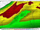
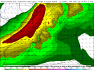
Nam is definitely more impressive in the two comparative runs. But we also got to remember it's the tail end of the NAM, I'd love to see a few more runs with also a similar solution in the euro as wellLast few runs of the GFS look quite different compared to earlier runs. Latest 12Z NAM, which runs up until 00Z Tuesday, looks more aggressive.
View attachment 22063View attachment 22064


Remember folks. You don't have to have 1000+ CAPE to have a severe threat across the South plus a strong low level jet would compensate for the lack of instability.
Yeah people fail to realize a lot of our winter tornado outbreaks are below 1000j lol.Remember folks. You don't have to have 1000+ CAPE to have a severe threat across the South plus a strong low level jet would compensate for the lack of instability.
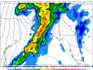
Certainly. Would want to see something a little higher in terms of confidence in the usual high-shear low-CAPE event in the South but it never takes much. The wind fields also look quite conducive at the end of the 18Z NAM (pictured is from north-central LA).Remember folks. You don't have to have 1000+ CAPE to have a severe threat across the South plus a strong low level jet would compensate for the lack of instability.

That euro run looks good though. Get below 1000mb and my eyes will pop a little more lol. I'm excited
- Moderator
- #1,788
I just hope it waits until after my medical test Tuesday morning.
Is it just me or does it always seem like you have appointments or something when there's severe weather?I just hope it waits until after my medical test Tuesday morning.
- Thread starter
- #1,791
KevinH
Member
I will take squall over discrete any day lol12z Euro has a pretty stout squall line along with a strong jet at both 500mb and 250mb.
- Moderator
- #1,792
Is it just me or does it always seem like you have appointments or something when there's severe weather?
I have a lot of appointments. lol
Hardly ever get discrete supercells in the winter, it's typically broken QCLS tornado events. Which seems the probable route. Even a regular QCLS can produce low end tornado outbreaks sometimes.I will take squall over discrete any day lol
Not that this will turn out as one. But I think we should keep our eyes peeled most winter events are messy and more QCLS'esk. And this one looks to fit the bill.
Really think the best area will likely be Mississippi. Once that sun falls the little instability left in the atmosphere will drop off a cliff. If this system can get deeper you may be looking at dynamic cooling which will help to destabilize things a bit more, but in the winter there's not a whole lot to work with in terms of any substantial instability.
*Although looking at the 00z Nam it looks like the main gist of the storms come through at night in Mississippi and still have a decent bit of instability (for a winter event) in place.
Last edited:
Copied from my laptop, so that may be why there isn't a preview.
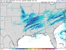
Interesting how the GFDL max updraft helicity are further north away from the coast.
Attachments
tennessee storm chaser
Member
- Messages
- 1,877
- Reaction score
- 4,288
- Location
- jackson tennessee
- Special Affiliations
- SKYWARN® Volunteer
There have been plenty winter events with discrete mode being the main…. But you got have higher end instability. January 1999. February 2008 name few top my headHardly ever get discrete supercells in the winter, it's typically broken QCLS tornado events. Which seems the probable route. Even a regular QCLS can produce low end tornado outbreaks sometimes.
Not that this will turn out as one. But I think we should keep our eyes peeled most winter events are messy and more QCLS'esk. And this one looks to fit the bill.
Really think the best area will likely be Mississippi. Once that sun falls the little instability left in the atmosphere will drop off a cliff. If this system can get deeper you may be looking at dynamic cooling which will help to destabilize things a bit more, but in the winter there's not a whole lot to work with in terms of any substantial instability.
*Although looking at the 00z Nam it looks like the main gist of the storms come through at night in Mississippi and still have a decent bit of instability (for a winter event) in place.
Idk, maybe its just in my head but I've always thought winter events where mainly messy QCLS events due to usually the less instability.There have been plenty winter events with discrete mode being the main…. But you got have higher end instability. January 1999. February 2008 name few top my head
- Moderator
- #1,799
Idk, maybe its just in my head but I've always thought winter events where mainly messy QCLS events due to usually the less instability.
The Enigma Outbreak of 1884 was in February and there have been lots of higher-end, destructive tornadoes during the winter months. They don't really "follow the rules."
CheeselandSkies
Member
The Enigma Outbreak of 1884 was in February and there have been lots of higher-end, destructive tornadoes during the winter months. They don't really "follow the rules."
12/10/21...that is all.
But yes, it does require the ingredients to actually come together in a favorable fashion, just like any other time of year.