- Thread starter
- #1,761
KevinH
Member
Well now I wonder why the previews work for some and not others???? :/I have a OnePlus
Follow along with the video below to see how to install our site as a web app on your home screen.
Note: This feature may not be available in some browsers.
Well now I wonder why the previews work for some and not others???? :/I have a OnePlus
Samsung is just superior. That's it.Well now I wonder why the previews work for some and not others. :/
When it comes to TVs, yes Samsung (used by @Clancy) and OnePlus (used by @UncleJuJu98) both use the Android operating system.Samsung is just superior. That's it.
 )
)Definitely could be. 18Z GFS shows convection dragging out across AL/GA on Tuesday with that setup, possibly bringing it into the warmer part of the day for those areas.Someone help me out here. I couldn't help but notice on the 18z GFS Composite Reflectivity. What appears to be a secondary low trying to form in the black circle area and where I would assume a warm front would be located in red. Correct me if I'm wrong, but to me, that's definitely what it looks like. @JBishopwx
That would also imply a greater risk of flash flooding across parts of North MS and surrounding areas if that were to verify.Definitely could be. 18Z GFS shows convection dragging out across AL/GA on Tuesday with that setup, possibly bringing it into the warmer part of the day for those areas.
Could result in a classic Dixie wedge situation with soaking rains north and severe convection south.That would also imply a greater risk of flash flooding across parts of North MS and surrounding areas if that were to verify.
Wait… when you say “wedge”?Could result in a classic Dixie wedge situation with soaking rains north and severe convection south.
 lol
lolSoooooooThe 18z GFS CWASP run is interesting to say the least.
That path looks familiar doesn’t itSomeone help me out here. I couldn't help but notice on the 18z GFS Composite Reflectivity. What appears to be a secondary low trying to form in the black circle area and where I would assume a warm front would be located in red. Correct me if I'm wrong, but to me, that's definitely what it looks like. @JBishopwx


Post. Pictures!06z euro looks pretty potent at the end of the run. Looks like a better ejection will occur more so than the 06z gfs
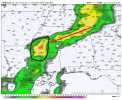
...DISCUSSION...
...D4/Monday - ArkLaTex into parts of the Southeast...
Extended-range guidance is in general agreement regarding the
synoptic-scale pattern across the CONUS on D4/Monday. A vigorous
mid/upper-level shortwave trough is forecast to pivot eastward
across the southern Plains/ArkLaTex region, to the south of a
weakening midlevel cyclone over the central Plains. However,
considerable uncertainty (with regard to both run-to-run
deterministic changes and ensemble spread) remains regarding the
details, which will impact the magnitude and placement of the
primary severe-thunderstorm threat on D4/Monday.
Generally speaking, mid 60s F dewpoints are expected to advance
northward across parts of east TX into the lower MS Valley, east of
a surface cyclone and trailing cold front that will approach the
ArkLaTex/ArkLaMiss regions by early evening. Initial thunderstorm
development is expected by late afternoon across parts of east TX,
with an increase in storm coverage Monday night as the shortwave
pivots through the base of the positively tilted trough. Strong
deep-layer shear will support organized convection and at least some
severe-thunderstorm threat where sufficient destabilization can
occur. The threat is likely to be maximized near and just south of
the surface-low track, which remains somewhat uncertain at this
time.
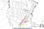
...D5/Tuesday - Parts of the Southeast...
Depending on the timing and intensity of the primary mid/upper-level
shortwave trough and surface cyclone, some severe threat may linger
into Tuesday across parts of the Southeast, within an environment
characterized by relatively rich low-level moisture, strong
deep-layer flow/shear, and weak instability. A separate area of
threat could materialize across parts of the Carolinas Tuesday
night, in association with a secondary low-level moisture surge, but
uncertainty regarding instability remains too high to include any
15% areas at this time.
..Dean.. 11/17/2023