- Thread starter
- #1,621
KevinH
Member
Why do Twitter.com links work on here but not x.com when they are used?
Follow along with the video below to see how to install our site as a web app on your home screen.
Note: This feature may not be available in some browsers.
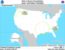
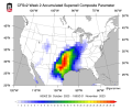
Just saw this for next week
11 1/2 month severe season rolls on...
The 2nd severe lolTo be fair though, we are now into our "typical" severe season.
The 2nd severe lol
Although, I think severe season lasts from Nov-Apr/May
Fair…. I started to put mid October but…. lolThere's been more and more tornadoes or tornado threats happening in mid/late-October in recent years. But still not as frequent as November/December onward.
Same! I might get my first thunderstorm this Thursday in I don't how long. Will be nice to hear thunder again.Everyone’s favorite meteorologist was showing a potential system around Wednesday next week 24-25. I just want a couple good rains across the SE. I’m sure we’ll be flooding by January.
If there's any truth to the dream I had last night, look for a severe weather threat around week after Thanksgiving. About Wednesday December 6th.

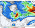
Wasn’t this your dream?00z Euro Ensemble Control has what would likely be a big severe weather threat going into the first week of November. That temperature difference is just asking for trouble.

No. That one was a different threat for the week after Thanksgiving.Wasn’t this your dream?
Oh ok lolNo. That one was a different threat for the week after Thanksgiving.
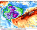
This system has Texas and Oklahoma in its sights. Too far out to make a precise forecast, but it looks to be really, really strong. It's caught my attention even this far away, and I'm already watching it. It cuts off before the system can move further east, but it looks like it's holding together through to Arkansas as it reaches the Mississippi River. The model I was looking at their cuts off at that point, like to see if it shows up again tomorrow.Oh ok lol