
Navigation
Install the app
How to install the app on iOS
Follow along with the video below to see how to install our site as a web app on your home screen.
Note: This feature may not be available in some browsers.
More options
-
Welcome to TalkWeather! We see you lurking around TalkWeather! Take the extra step and join us today to view attachments, see less ads and maybe even join the discussion. CLICK TO JOIN TALKWEATHER
You are using an out of date browser. It may not display this or other websites correctly.
You should upgrade or use an alternative browser.
You should upgrade or use an alternative browser.
Severe Weather Threat - June 17th-18th, 2023
- Thread starter Taylor Campbell
- Start date
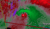
Yeah looks like it's about to drop.That is a tight, tight low-level couplet due north of KDGX.
OHWX97
Member
There's a possible debris signature north of Strong, AR. Not a very deep CC drop but it matches up with the velocity couplet.
CheeselandSkies
Member
Generally when you can make out clear couplets/hooks less than 300' AGL, it's not good.
Thank you! Hope we can avoid any more tornadoes in Monroe County MS, but with the luck I've had this year, I'm not too sure.Good call @JPWX
CheeselandSkies
Member
There's a possible debris signature north of Strong, AR. Not a very deep CC drop but it matches up with the velocity couplet.
If that is a tornado, it's lofting debris to 10,000' given how far that is from any radar.
- Admin
- #167
CheeselandSkies
Member
The storm speed of the Brandon cell went from 50 MPH, to 20 MPH with the next warning statement???
Tornado just north of DGX now confirmed.
Mesoscale update for that cell and the adjacent one.
**Strong tornado possible***
TH2002
Member
- Messages
- 4,974
- Reaction score
- 11,116
- Location
- California, United States
- Special Affiliations
- SKYWARN® Volunteer
Good catch. I think that’s a legit debris signature since the CC drop is moving SE with the couplet.There's a possible debris signature north of Strong, AR. Not a very deep CC drop but it matches up with the velocity couplet.

OHWX97
Member
I'm pretty confident that's debris signature now. Not good...If that is a tornado, it's lofting debris to 10,000' given how far that is from any radar.

Timhsv
Member
Mesoscale update for that cell and the adjacent one.
**Strong tornado possible***
VTP near the Columbus radar is near 12 now. Awaiting tornadogenesis
Yeah may get nasty if one truly gets going and has some separation. Nocturnal jet is picking up some now that the sun is down.VTP near the Columbus radar is near 12 now. Awaiting tornadogenesis
warneagle
Member
whoa
The mesoscale on that supercell just northeast of Jackson is becoming really impressive. It's the one highlighted by the NWS... Watch out.
Looks like a bit of a merger here in a second so it may take a minute to recoup.
Looks like a bit of a merger here in a second so it may take a minute to recoup.
atrainguy
Member
Looks like this warning just got updated to observed status.