• Welcome to TalkWeather!
    We see you lurking around TalkWeather! Take the extra step and join us today to view attachments, see less ads and maybe even join the discussion.
    CLICK TO JOIN TALKWEATHER

Winter Weather Season 2025-26

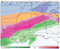
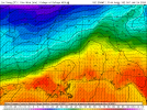
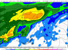
Major no bueno situation on those runs. That's got my attention more than a tornado outbreak if things don't change; anything more than a quarter inch would be pretty devastating over a large area (and even a quarter inch would be very bad)

Good week to test out generators, battery banks, and emergency supplies honestly just in case. Got a wood stove in the basement here for heat but that only does so much all things considered
 
18z GFS still has it, but more snow (though less snow than 12z GFS) than ice/sleet
 
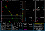
It's always tricky to pinpoint precip types and exact locations near the freezing line especially in southern events, but the temperature profiles in the forecast soundings are going to be pretty fascinating since it'll probably be a fairly classic overrunning situation
 
Those are some ugly maps. I've lived in the Birmingham area for all but two winters (1994-1995 and 1995-1996) since 1988 and have never experienced a major, crippling freezing rain event. I guess February of 1996 was pretty bad, but I missed that one. We had a lot of sleet in early January of 2011 at my place, along with some snow. It has always seemed that places both east and west of us are more prone to ice storms, but our luck will run out eventually!
 
Those are some ugly maps. I've lived in the Birmingham area for all but two winters (1994-1995 and 1995-1996) since 1988 and have never experienced a major, crippling freezing rain event. I guess February of 1996 was pretty bad, but I missed that one. We had a lot of sleet in early January of 2011 at my place, along with some snow. It has always seemed that places both east and west of us are more prone to ice storms, but our luck will run out eventually!
I lived in Tuscaloosa at UA during that 1996 ice storm. The entire strip in Ttown was covered in ice and of course stupid college kids were still driving around and it was like bumper cars....so many wrecks.
 
Major no bueno situation on those runs. That's got my attention more than a tornado outbreak if things don't change; anything more than a quarter inch would be pretty devastating over a large area (and even a quarter inch would be very bad)

Good week to test out generators, battery banks, and emergency supplies honestly just in case. Got a wood stove in the basement here for heat but that only does so much all things considered
Seconded. Folks should double-check on their supplies. If nothing else, it'll get y'all ready for tornado season. Ice is no joke, doubly so for us down south.
 
Might want to get a thread going for this event. Lot of model consistency and even trustworthy meteorologists are honking the horn


OT but my parents gifted me a copy of Matthew Cappucci's book for my birthday yesterday (and my wife gave me Pecos Hank's, which I'd specifically asked for).

At my party my aunt & uncle were telling me about the ice storm of March 1976 which was unusually widespread and destructive even by Wisconsin standards. We haven't seen anything quite like that since.
 
I talked to Matthew last Saturday night and said I wanted a snowstorm. I open this and see he's giving me the exact opposite! I demand a refund! LOL!

Joking aside, I can't argue with the setup. Like I stated above, North MS is long overdue for a big one. I will say though that ice on trees makes for some very pretty pictures.
 
I remember an ice storm in Alabama of this (potential) strength in Jan. 1982. I remember hearing the pine trees snapping - so many limbs and trees that it was almost a constant roar of limbs breaking in the valley. There are pine trees alive today in the woods that are still bent at that point from that storm. Power was out for over a week. The back side of the system dropped a couple inches of snow on top of the inch of ice on everything, so the sledding on the roads was spectacular, but I was a kid at the time and not really paying attention to the emergency side of things.

 
I'm hoping we can reel in one of these 240 hour ice storms for northern Georgia in January. At least to make my shifts fun.

But, if the subtropical jet becomes more active like long range deterministic/ensemble modeling hints, we may be dodging severe and winter threats in Dixie before long.
I’ve been trying to reel in the elusive ice storm since page 3 of this thread. Maybe this is it!

In all seriousness, if the Euro solution comes remotely close to verifying, we’re in deep trouble.
 
It's definitely fascinating to see the cross section of winter storms on forecast soundings; just north of Houston on the 18z GFS with that overrunning warm nose evident in both temperature and wind profiles bringing such a classic freezing rain/ice storm profile to a pretty big area. Fingers crossed we trend away from that, but who knows? Synoptics look concerningly classic

gfs_2026011818_150_30.25--95.0.png
 
OT but my parents gifted me a copy of Matthew Cappucci's book for my birthday yesterday (and my wife gave me Pecos Hank's, which I'd specifically asked for).

At my party my aunt & uncle were telling me about the ice storm of March 1976 which was unusually widespread and destructive even by Wisconsin standards. We haven't seen anything quite like that since.
I follow Matt and Hank pretty closely, had no idea they wrote books. I’ll have to check them out.
 
Back
Top