
While I would love for it to verify for you all, I'm going to throw out there that the RAP is possibly seeing sleet as accumulating snow. IJS
Navigation
Install the app
How to install the app on iOS
Follow along with the video below to see how to install our site as a web app on your home screen.
Note: This feature may not be available in some browsers.
More options
-
Welcome to TalkWeather! We see you lurking around TalkWeather! Take the extra step and join us today to view attachments, see less ads and maybe even join the discussion. CLICK TO JOIN TALKWEATHER
You are using an out of date browser. It may not display this or other websites correctly.
You should upgrade or use an alternative browser.
You should upgrade or use an alternative browser.
Winter Weather 2025
- Thread starter Thanksgivingbrown
- Start date
Already 50 degrees here in extreme southwest Blount county.
50 at 5:39
48 at 6:19
48 at 6:50
50 at 5:39
48 at 6:19
48 at 6:50
Last edited:
The Bammer
Member
46 sw Cullman CountyAlready 50 degrees here in extreme southwest Blount county.
50 at 5:39
48 at 6:19
The Bammer
Member
Geno
Member
51 in Tuscaloosa.
That dusting line looks like it has me in itEuro picking up on that streak as well through north Alabama? ( p.s. You guys really know what you are looking at. I'm just a weather enthusiast at best)
Geno
Member
50 now and falling. NWS claims 35 here for the low.
I'm curious to see how temperatures do, considering it's a artic air mass. Sometimes they don't handle it well.50 now and falling. NWS claims 35 here for the low.
Geno
Member
Do they err on the warm side very often?
Not sure, I think it's just the shallow sense air that makes it hard for models to grasp. That's at least what I've heard before; Don't take it as gospel. A few degrees difference would be big for some areasDo they err on the warm side very often?
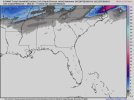
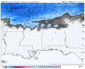
It's true that models have a hard time seeing the cold air especially shallow arctic air. Which is another reason why you're seeing the mesoscale models such as the RAP and HRRR trying to say "hey you might be surprised with more snow than currently forecasted." To add to this, the GFS, Canadian, and NAM are the main ones showing more sleet/freezing rain. My guess in that regard is they're having difficulty seeing this shallow cold air. Because, if you look at the HRRR for instance, it's showing yeah some sleet (not much though) and very little freezing rain. Having said that though, the 18z GFS has definitely shifted the 1-3 inch snowfall southward. Overall, this looks more snow than sleet/freezing rain threat.
Attachments
Last edited:
2 inches for me. I'll take that.It's true that models have a hard time seeing the cold air especially shallow arctic air. Which is another reason why you're seeing the mesoscale models such as the RAP and HRRR trying to say "hey you might be surprised with more snow than currently forecasted." To add to this, the GFS, Canadian, and NAM are the main ones showing more sleet/freezing rain. My guess in that regard is they're having difficulty seeing this shallow cold air. Because, if you look at the HRRR for instance, it's showing yeah some sleet (not much though) and very little freezing rain. Having said that though, the 18z GFS has definitely shifted the 1-3 inch snowfall southward. Overall, this looks more snow than sleet/freezing rain threat.
00z Rap puts 2+ inches of snow over downtown bham.
I'm a bit intrigued now.
What's the chance of a Christmas miracle tommorow? Hahah
I guess the dynamic cooling is enough to give us heavy snow along a certain corridor.
I'm a bit intrigued now.
What's the chance of a Christmas miracle tommorow? Hahah
I guess the dynamic cooling is enough to give us heavy snow along a certain corridor.
Based on the model blend, I think rain/snow line somewhere between Warrior and Cullman. Keeping an eye on the Gulf - some interesting convection firing - and no shortage of it.

46 degrees here now.
Geno
Member
49 in Tuscaloosa where I am but 45 at a nearby ws and all over the map in my area 44-52.
Geno
Member
It is insanely cold behind this system. Single digits and closing in on zero f in north TX already. Anything that does fall will be here for a while.
Pluviophile
Member
I can't believe how quiet it is. Where did everyone go?? Also, is it snowing in northern Mississippi? I'm waiting in north Alabama.this thread has been very quiet, I assume this is going to be a big nothing burger for the most part?
- Moderator
- #240
I think it's a combination of things but mostly that we've already had a good year for snow in the SE. Several inches in New Orleans! If the totals were more impressive and coverage expanded further south we'd see much more activity. I'm sure we'll get some cool snow photos after sunrise though from a few peopleI can't believe how quiet it is. Where did everyone go?? Also, is it snowing in northern Mississippi? I'm waiting in north Alabama.
")