wx_guy
Member
- Messages
- 1,237
- Reaction score
- 4,443
- Location
- United States
- HAM Callsign
- KO4ZGH
- Special Affiliations
- SKYWARN® Volunteer
- ARRL Member
0z HRRR coming soon....*hype*
Follow along with the video below to see how to install our site as a web app on your home screen.
Note: This feature may not be available in some browsers.
Its going to go 100 miles north and blockbuster blizzard for Alabama. Calling it0z HRRR coming soon....*hype*
")
Good deal...just looking at the different model runs, the precip shield seems to be mostly south of us, with the exception of a 3-hour period. So, I just looked at the SREF snow depth map and it seems higher than what they are calling for. Is this based on a blend of models?Yeah your gunna get some snow man lol

I didn’t see any this evening, but I saw virga earlier.Is anyone in the Birmingham area seeing any flurries now? https://radar.weather.gov/ridge/standard/KBMX_loop.gif


I'm going with what the Canadian has been showing for the past week !Its going to go 100 miles north and blockbuster blizzard for Alabama. Calling it
Might need a pitch fork. No one north I 20 getting any accumulating snow .I'm currently looking for a fork.....
Maybe even I 85Might need a pitch fork. No one north I 20 getting any accumulating snow .
Decent Flizzard here. Won't last long

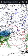
Why do you think the isobar kink is the cutoff?Just about every model is showing some kind of.kink in the isobars like i highleted below. I really think thats where the snow cutoff will be.
Because north of that line there is anticyclonic curvature...the high is pressing in causing downward motionWhy do you think the isobar kink is the cutoff?
Mighty close to causing issues in Birmingham lol. Hopefully this isn't a snowmageddon case we're a heavy snow band initiated a good bit northwest than modelled. I expect my work will not let us drive if there's any doubt at there being frozen precip. ( Drive large trucks )Because north of that line there is anticyclonic curvature...the high is pressing in causing downward motion
Same here. I do home health in the metro area. I got stuck for 12 hours on I-20, trying to get home from a patient's house in snowmageddon.Mighty close to causing issues in Birmingham lol. Hopefully this isn't a snowmageddon case we're a heavy snow band initiated a good bit northwest than modelled. I expect my work will not let us drive if there's any doubt at there being frozen precip. ( Drive large trucks )