- Moderator
- #661
New MD issued. Incredible reflectivity imagery knowing it is heavy snow.

Mesoscale Discussion 0052
NWS Storm Prediction Center Norman OK
0452 PM CST Tue Jan 21 2025
Areas affected...Far Southeast Louisiana...Far Southern Mississippi...Far Southern Alabama...Florida Panhandle
Concerning...Heavy snow
Valid 212252Z - 220445Z
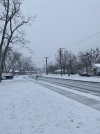
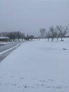
SUMMARY...Heavy snow will be likely over the next few hours along parts of the central Gulf Coast from far southeast Louisiana into the Florida Panhandle and southern Alabama. Snowfall rates are expected to exceed 1 inch per hour within the heaviest parts of the band.
DISCUSSION...Water vapor imagery shows a mid-level trough from the Ohio Valley extending southwestward into the lower Mississippi Valley. A powerful mid-level jet of 100 to 140 knots is located to the east of the trough, with the exit region of this jet located in the central Gulf Coast region. Widespread precipitation is ongoing beneath this feature (where lift is strong) from far southeast Louisiana east-northeastward into the Florida Panhandle and southern Alabama. Most of the precipitation is in the form of snow, with some reports of heavy snow. The latest model forecasts suggest that a band of strong isentropic ascent will continue to spread eastward across the central Gulf Coast region, making conditions favorable for heavy snow over the next few hours. Snowfall rates are expected to exceed 1 inch per hour in some locations. The potential for heavy snow is expected to continue into early to mid evening over southern Alabama and the Florida Panhandle. Further to the west, snowfall rates should gradually decrease over parts of far southeast Louisiana and southern Mississippi.
..Broyles/Smith.. 01/21/2025