sak
Member
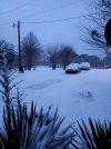
looking like another 30 minutes of freezing rain here before i get dry slotted. inexpect to be above 32 when the precip back in MS makes it here.
Follow along with the video below to see how to install our site as a web app on your home screen.
Note: This feature may not be available in some browsers.
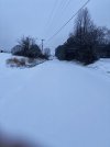
 ..probably due to latent heat release due to freezing rain.
High pressure in the NE US pushing cold air down the eastern side of the Appalachian Mountains. It can cause colder conditions as far south and west as north AL especially NE AL. AKA "the wedge."What is cold air damming?

Special Weather Statement
National Weather Service Peachtree City GA
747 AM EST Fri Jan 10 2025
GAZ001>009-011>016-019>025-027-030>039-041>062-073-101315-
Chattooga-Fayette-Walker-Coweta-Newton-Henry-Whitfield-Hall-Catoosa-
Warren-Cherokee-Bartow-Dade-Oconee-Fannin-Hancock-Gwinnett-White-
Paulding-Gilmer-Madison-Polk-Union-Towns-Gordon-Greene-Floyd-
Taliaferro-Wilkes-Butts-Morgan-Putnam-Heard-Jackson-North
Fulton-Barrow-Baldwin-Cobb-Pickens-Spalding-Banks-Dawson-Walton-
Rockdale-Carroll-Forsyth-Jasper-Murray-Lumpkin-South
Fulton-Douglas-Clayton-Haralson-DeKalb-Oglethorpe-Clarke-
747 AM EST Fri Jan 10 2025
...A BAND OF HEAVY SNOW...
At 739 AM EST, a band of sleet transitioning to moderate to heavy
snow was located over the southern Atlanta metro and points east,
moving northeast at 35 mph.
HAZARD...A band of snow that is accumulating quickly.
SOURCE...NWS Meteorologists
ACCUMULATION...Quick accumulations of half an inch to an inch.
TEMPERATURES...Temperatures are expected to fall or remain steady.
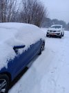
IMPACT...Snow is quickly accumulating on top of sleet that fell
earlier. Roadways are quickly becoming hazardous. Travel is
not advised.
Locations impacted include...
Atlanta, Marietta, Rome, Gainesville, Dalton, Newnan, Douglasville,
Lawrenceville, Carrollton, Canton, McDonough, Cartersville, Decatur,
Fayetteville, Calhoun, Conyers, Winder, Monroe, Covington, and
Dallas.
PRECAUTIONARY/PREPAREDNESS ACTIONS...
The snow can accumulate at a rate of one inch per hour in this band
of heavy snow. Be prepared for hazardous driving conditions.
Consider delaying travel if you will be going through this band of
heavy snow.
LAT...LON 3499 8355 3480 8368 3474 8362 3449 8366
3443 8361 3449 8354 3446 8340 3424 8334
3427 8311 3417 8310 3401 8293 3398 8265
3364 8248 3366 8251 3361 8265 3342 8256
3313 8296 3331 8449 3320 8525 3498 8560
TIME...MOT...LOC 1239Z 238DEG 31KT 3356 8425
$$