
Navigation
Install the app
How to install the app on iOS
Follow along with the video below to see how to install our site as a web app on your home screen.
Note: This feature may not be available in some browsers.
More options
-
Welcome to TalkWeather! We see you lurking around TalkWeather! Take the extra step and join us today to view attachments, see less ads and maybe even join the discussion. CLICK TO JOIN TALKWEATHER
You are using an out of date browser. It may not display this or other websites correctly.
You should upgrade or use an alternative browser.
You should upgrade or use an alternative browser.
Winter threat: 1/9-12/ 25
- Thread starter DetectiveWX
- Start date
Could be here a while - decent thaw on Sunday from what I've heard, but then another shot of artic air comes in. Really depends on how much is on the ground I guess. GFS shows another system in 10 days or so as all rain, but that's of course voodoo land.how long will this potentially stick around if it does come to fruition? I am not just now tracking this.
There is a considerable difference between 12z nam and 12z gfs on 850mb temps....differences that can be partially explained by the track but still warmer on the gfs than what you would expect.


I really wish it would stop showing 1/2in-ish areas of ice storms. Yet another brutal hit for NW GA, W SC, and W/Cen NC.
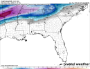
Looks like the entire 12Z GFS ensemble put that low pretty far north.


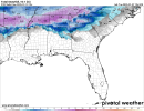
The mean showing rain/snow line around Bham. Go figure...lol.
The mean showing rain/snow line around Bham. Go figure...lol.
Thanksgivingbrown
Member
LFG!

What's this mean?
The gfs ensemble mean of last few runs trend keeps the low right along the coastline
cyelle21
Member
I'm hoping that the track of the low is further south. I'm near Selma and we always get left out when it comes to snow.
Weatherphreak
Member
I’m ready for a good snow dump around Huntsville. I was looking at pics and I think Feb 2015 was the last 6+ event we’ve had. Either way it could be Monday or Tuesday before the roads start clearing off.
Thanksgivingbrown
Member
It’s means there’s a high confidence of measurable snowfall for the Tennessee Valley. The fact it has this level of confidence this far out is rare for the valleyWhat's this mean?
Thanksgivingbrown
Member
Weather channel puts the Tennessee Valley in the bullseye
I'd love to see member 10 verify. Weaker low, further south, all snow. Buries N AL and ATL.The gfs ensemble mean of last few runs trend keeps the low right along the coastline
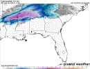
12z Canadian is the only global model showing ice storm potential. 12z GFS, Euro, UKMET, and NAM all snow. Though I don't quite understand why the 12z UKMET has lower snow totals now unless it has more sleet/freezing rain involved.
Attachments
aujerm
Member
the 12z euro is trending warmer with 850mb temps. So the Canadian and other models hinting at ice may be onto something. Hopefully the 00z run will correct back lower.
Seems like the globals shifted the ice storm threat east - likely in response to the snowpack ice cube being ingested into initialization and thus colder initial temps west. They all taper off snow amounts east and GFS still has some nasty freezing rain in the mountains of NW GA and W SC, but perhaps that snowpack is showing up as our helper with any ice storm threat here? Thank you Kansas City, lol.12z Canadian is the only global model showing ice storm potential. 12z GFS, Euro, UKMET, and NAM all snow. Though I don't quite understand why the 12z UKMET has lower snow totals now unless it has more sleet/freezing rain involved.
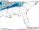
Looks like a period of heavy snow early on i20 then switch to freezing rain, then a back to snow toward the end. Snow accumulation totals will be brief as the changeover occurs/packing and or melting
Last edited:
They are already in place in north/northcentral TexasI wouldn’t be surprised to see winter weather watches issued as early as tonight
Thanksgivingbrown
Member
Exactly, that’s why I expect them to spill out further east later tonightThey are already in place in north/northcentral Texas