David in SW Blount
Member
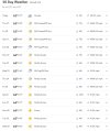
I see Yorba Linda hitting a homer with 89. That was the first place I lived (until almost age 5). No wonder I like warm weather!
Follow along with the video below to see how to install our site as a web app on your home screen.
Note: This feature may not be available in some browsers.
I see Yorba Linda hitting a homer with 89. That was the first place I lived (until almost age 5). No wonder I like warm weather!

Hopefully we can get the gloomy and damp weather back to Seattle and Portland where it belongs soon.Once again the FD helped me learn something. I have noticed recently, outside my window and also in the forecast, that north winds start during the day and then taper off at night, which is not usual here.
Per the forecast discussion, we have a Rex block set up, and I read about the basics of that (high pressure system north of closed low pressure system).
The AI told me this in a search (emphasis added):
"During a Rex block, the wind direction can be altered due to the high and low pressure systems involved. The high pressure system, located north of the low pressure system, creates a clockwise wind circulation, while the low pressure system creates a counterclockwise wind circulation. This can result in winds blowing from the north-northeast between the two pressure centers, especially in areas where the high pressure is located."
That's us - we're in the high pressure part (and basking in the unusually warm temps and sunny days).
Thanks, NWS!

 )
)


It’s only MAY! I live in central Virginia and we nearly hit 90 on APRIL 3RD! We hit 87 that day and then we hit 87 again at the end of April (April 30th). Something tells me this is going to be our average summer.I know we usually talk about severe weather here, but unbelievably we're moving in a summer very fast. View attachment 41385
Temperature is in FI have made a graph of my temps that I have been recording for my location since April 5th (With memory input from April 3rd and April 4th)
View attachment 42972