Today still looks pretty concerning to me with increasing chances of a severe weather outbreak.

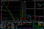
Latest runs (RAP depicted here) have if anything tightened the Midwest shortwave, encouraging initiation of discrete storms there through the afternoon - perhaps in a line down from IN down to as far as KY/TN border areas, which would move East through the afternoon. The environment still looks favorable for long track intense tornadoes with any sustained supercells, but we will have to watch for surface backing and LLJ increases which could alter shear profiles for the better or worse through the day.
At this stage the main limiting factors appear to be:
- The outflow from the current storms restricting the northern extent of the warm sector. This probably had the indirect effect of moving the surface slow slightly further south, or at least reducing backing slightly in the warm sector which has resulted in an ever so slight decrease of forecast wind profiles there this morning. Still, I think quite a lot of these setups have underestimated the extent of surface backing so I wouldn't really be surprised to see it trend back through the course of the day. Additionally, almost all models are pretty aggressive with the moisture return - HRRR has dews near 70F in areas currently under storms, probably as a result of terrain induced advection that Sam Brandt mentioned yesterday. Its also possible that the outflow boundary is modified and moved north to provide a slightly enhanced zone of shear - but this scenario seems unlikely as it would require a lot to 'go right' to have any influence on tornadic activity. Current radar observations show the MCS to have slightly more coverage and intensity than I think most models anticipated at this time and its possible the most southern activity currently over MO/IL may take a while to clear. Best case scenario this lingers all day, preventing proper destabilization at least across parts of the warm sector but we will also have to watch it in case it becomes surface based once again across NE KY in the afternoon as a couple CAMS are suggesting, though not worth worrying about this time and overall the current situation with the MCS should help to temper the threat at least a bit.
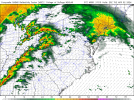
- It looks like a small disturbance in the flow will evolve across MS/AL through the late morning and afternoon, helping to initiate showers and storms. A lot of CAMS show this becoming quite a rainy mess however I'm wondering if this is a bit unrealistic: The air around this band looks fairly dry, especially from the back with the mid-level dry air 'punch' pushing through - moreover the forcing should be quite subtle, not necessarily supporting large areas of stratiform rain at least initially. Its bound to happen eventually as storms mature but I would expect this process to take longer than some of the CAMS suggest. In fact, with 1500j/kg of ML CAPE, locally higher: its quite possible some of these cells evolve into powerful supercells across TN/KY as they move northeast into stronger low level shear. The HRRR (and NAM), which was even more of the messier models - depicts this. Strong-intense tornadoes would in theory be possible with any supercells here. Once this band really gets going moisture return will of course be cut off to the northern risk area - but if the moisture is already in place by then this should in theory not matter.

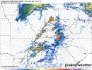
With the even stronger shortwave, I am confident convection will be initiated from IN initially down into KY, and then evolve into a couple dominant supercells given the high instability, dry punch helping to keep things fairly discrete. Even if not right away, as they move NE further into KY, IN and then eventually OH, these storms should eventually become tornadic given the very strong low level wind shear. Even with all the messiness and uncertainty - almost all CAMS display at least one or two storms that would in theory be capable of EF3+ tornadoes.

At the highest end, we are looking at two main zones of discrete or semi-discrete storms (HRRR, NAM, RRFS, some of the new NSSL models). This would be very bad of course. The best case is that these two main zones interfere to the point either one or even none of them have anything significant tornado wise. Once the current storms are moved through we will be able to get a better idea of the situation but I am really hoping we see signs of this event downtrending soon.


.png")
.png")
.png")