KevinH
Member
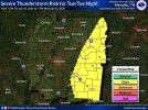
I almost hate to do this BUT here we are. While it is too early to say how this potential event will perform, we can still have fun discussing it ")
The SPC isn’t QUITE ready to pull the trigger on highlighting an area, but I would not be surprised if they did for the time frame indicated. The wide area of warm DPs gets my attention.
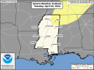
Day 4-8 Convective Outlook
NWS Storm Prediction Center Norman OK
0359 AM CDT Wed Mar 27 2024
Valid 301200Z - 041200Z
...DISCUSSION...
An upper trough/low should continue to move south-southeastward over the western states on Day 4/Saturday. Over much of the central CONUS, upper ridging should generally prevail, with a gradual northward advance of low-level moisture across the southern Plains. Although a plume of elevated instability should accompany this moisture return, a cap is expected to suppress robust convective development Saturday.
On Day 5/Sunday, the upper trough/low over the western CONUS should slowly advance eastward across the Southwest. But, there are still some differences in various guidance with the evolution of this trough/low. Some GEFS ensemble members show a slower ejection, with a closed 500-mb isohypse remaining over the West. Other members align more with the deterministic ECMWF is showing a more open wave, but with a positive tilt into the northern/central Plains. Another potentially complicating factor is a northern-stream upper trough, which may phase with the lower-latitude trough and help induce stronger cyclogenesis across the mid MS Valley/Midwest around Day 6/Monday.
Even with these continued differences, it appears that severe potential should gradually increase from Sunday into Monday across parts of the southern/central Plains, mid MO into mid MS Valleys, and perhaps also into the OH Valley/Midwest.
For Sunday, some severe potential may be focused across parts of MO into IL along and near a sharpening surface warm front. Mid-level height tendencies look to remain neutral through Sunday evening across this area, with nebulous large-scale ascent. Even so, low-level warm advection may help initially elevated convection to develop across MO in a moderate instability and strong deep-layer shear environment. If this occurs, then some severe threat may continue eastward into IL through Sunday evening. At this point, too much uncertainty exists regarding thunderstorm initiation and coverage to include a focused 15% severe area for Sunday.
A larger area of severe potential may be realized on Monday from parts of the southern/central Plains into the mid MS and OH Valleys. This will be largely dependent on the timing of ejection of the upper trough over the Southwest, and whether it can phase any with a northern-stream trough moving southeastward out of central Canada. Regardless, a broad warm sector, with 60s surface dewpoints, should be in place from TX/OK east of a dryline and northward to a warm front located somewhere in the vicinity of the OH Valley. The exact placement of these surface features remains rather uncertain Monday, as does the potential strength and northeastward track of a surface low across the mid MS and OH Valleys. Deep-layer shear appears strong enough to support organized severe thunderstorms, a consideration was given to adding a broad 15% severe area for Monday. But, there still seems to be too much spread in possible solutions with the upper trough to introduce an area yet.
Finally, some severe threat may continue on Day 7/Tuesday along and ahead of a cold front moving across parts of the Southeast and eastern states. But, predictability remains very low at this extended time frame.
The SPC isn’t QUITE ready to pull the trigger on highlighting an area, but I would not be surprised if they did for the time frame indicated. The wide area of warm DPs gets my attention.
Day 4-8 Convective Outlook
NWS Storm Prediction Center Norman OK
0359 AM CDT Wed Mar 27 2024
Valid 301200Z - 041200Z
...DISCUSSION...
An upper trough/low should continue to move south-southeastward over the western states on Day 4/Saturday. Over much of the central CONUS, upper ridging should generally prevail, with a gradual northward advance of low-level moisture across the southern Plains. Although a plume of elevated instability should accompany this moisture return, a cap is expected to suppress robust convective development Saturday.
On Day 5/Sunday, the upper trough/low over the western CONUS should slowly advance eastward across the Southwest. But, there are still some differences in various guidance with the evolution of this trough/low. Some GEFS ensemble members show a slower ejection, with a closed 500-mb isohypse remaining over the West. Other members align more with the deterministic ECMWF is showing a more open wave, but with a positive tilt into the northern/central Plains. Another potentially complicating factor is a northern-stream upper trough, which may phase with the lower-latitude trough and help induce stronger cyclogenesis across the mid MS Valley/Midwest around Day 6/Monday.
Even with these continued differences, it appears that severe potential should gradually increase from Sunday into Monday across parts of the southern/central Plains, mid MO into mid MS Valleys, and perhaps also into the OH Valley/Midwest.
For Sunday, some severe potential may be focused across parts of MO into IL along and near a sharpening surface warm front. Mid-level height tendencies look to remain neutral through Sunday evening across this area, with nebulous large-scale ascent. Even so, low-level warm advection may help initially elevated convection to develop across MO in a moderate instability and strong deep-layer shear environment. If this occurs, then some severe threat may continue eastward into IL through Sunday evening. At this point, too much uncertainty exists regarding thunderstorm initiation and coverage to include a focused 15% severe area for Sunday.
A larger area of severe potential may be realized on Monday from parts of the southern/central Plains into the mid MS and OH Valleys. This will be largely dependent on the timing of ejection of the upper trough over the Southwest, and whether it can phase any with a northern-stream trough moving southeastward out of central Canada. Regardless, a broad warm sector, with 60s surface dewpoints, should be in place from TX/OK east of a dryline and northward to a warm front located somewhere in the vicinity of the OH Valley. The exact placement of these surface features remains rather uncertain Monday, as does the potential strength and northeastward track of a surface low across the mid MS and OH Valleys. Deep-layer shear appears strong enough to support organized severe thunderstorms, a consideration was given to adding a broad 15% severe area for Monday. But, there still seems to be too much spread in possible solutions with the upper trough to introduce an area yet.
Finally, some severe threat may continue on Day 7/Tuesday along and ahead of a cold front moving across parts of the Southeast and eastern states. But, predictability remains very low at this extended time frame.


.png")