• Welcome to TalkWeather!
    We see you lurking around TalkWeather! Take the extra step and join us today to view attachments, see less ads and maybe even join the discussion.
    CLICK TO JOIN TALKWEATHER

Svr Wx threat April 1-April 2 2024

Interesting note on 18Z CAMs: NAM 3km is overall more aggressive on than HRRR, with substantial destabilization >1000 j/kg and good-looking hodos. While NAM can sometimes overdo the low-level winds, the intensification of instability across the area definitely has my attention, seeing as it very often is one of the least aggressive on instability of the CAMs.
sbcape_hodo.us_se.pngsbcape_hodo.us_se (1).png
 
While I have been personally less conservative for a while on tomorrow's threat - I think today's is a lot more balanced and on the margins, which in some ways makes it more interesting.

From the latest models, I'm (and I am just an amateur enthusiast so all this is based on self learned stuff and observations) seeing two main issues limiting today:
  1. The discrete mode is in my opinion somewhat conditional and isnt necessarily perfectly supported by the background synoptic or a nicely defined boundary. Not to say we wont see discrete storms evolving across SE OK later but I just find it harder to confidently say an intense tornado risk is present when we don't yet know about a long duration discrete mode in the same timeframe as when wind profiles improve later on. The mode will almost certainly be discrete initially with a massive hail risk, but shear will be much less favorable for strong tornadoes during this period. The opposition to that is that CAMS have been showing a pretty solid signal for a while now - this is quite hard to ignore
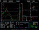
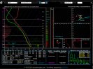
  2. I think the environment around the discrete cells could be a bit too dry. Storms will entrain a lot of dry air, will easily become outflow dominant and also have trouble producing intense tornadoes with such a cool/unbuoyant RFD if the storm ingests air as dry as this sounding suggests (taken SE from the Oklahoma discrete storm at 01z). That could also play into limiting the discrete mode as mentioned above. However, what's interesting is that proximity soundings which are contaminated but closer to the storm have a much more moist boundary layer - but its hard to draw the line of what is a realistic storm scale environmental modification which the storm would produce in the model as opposed to real life.
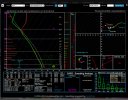
With those two caveats gone, the environment across SE Oklahoma after 00z does look to turn very favorable especially with regards to the enlarged hodographs. If we still have a discrete cell that can balance the various updrafts and downdrafts well enough, I think it’s a distinct possibility that an intense tornado could be produced. This is definitely a good scenario I could envisage the SPC using the 'double hatched' in the future: in one or two places things could become very bad - but the uncertainty of this is very high and I can understand them not wanting to upgrade to 15% at this point going on uncertainty and coverage issues.
Yeah I think the first point is the big catch: the low-level shear isn’t there right now and the window for discrete convection might not be long enough for the LLJ to really kick in and strengthen the low level shear before things grow upscale. Another “high end potential if it happens but lots of uncertainty” scenario, so I think sticking with 10 hatched is prudent. If nothing else there will be some type of QLCS tornado threat.
 
A High Risk would come down to amount of destabilization, storm mode, and mesoscale factors.
 
Any shot the SPC might upgrade to a High tomorrow?
I think that there is a decent chance. For a High to verify I think the SPC want everything to be supported from the synoptic level to the storm scale. We are definitely there at the top level (and I think that with this setup there was always a chance for it to end up like that which is why a lot of us were keeping a close eye on the models even a few days or more out). I think we are there in terms of the environment (most models now seem to depict an environment capable of intense-violent tornadoes pending a discrete mode).

The biggest uncertainties are at the moment how many discrete storms we get, how long they last, where etc - and I think the synoptic setup probably supports there being room for quite a few discrete supercells. The second big uncertainty is probably how storms further south interact with the main risk area: Just look at 3/28/2020 for a big Forecasted Convective Amplification Deficiency scenario for similar reasons. The one thing that may 'counteract' this is something I saw posted by Sam Brandt on twitter - Its possible the terrain in the Midwest and Ohio Valley where the main threat area is tomorrow forces moisture return into the WS and strengthens wind shear. He is probably one of the most knowledgeable people out there so I'm very interested to see him saying this. Either way, lets hope for the best for those in IN, OH and KY.


(not a meteorologist though ofc so these are just my thoughts and opinions)
 
Here's the historical metrics for days where Significant (EF2+/F2+) tornadoes occurred, in south-central Ohio, in the heart of the MDT risk tomorrow.

1712006908281.png


What strikes me is how low some of these metrics are to cause SIG tornadoes in Ohio. With the NAM forecasting STP values above 3, SCP over 13+, Eff Shear of 75+ knots, and ML LCL of 663, this paints a picture that's above even the box plot outliers for most of the SIG tornado days Ohio has seen...it may well be trending towards a HIGH day, depending on what the 0z and 12z model runs show...
 
15Z SREF demonstrates elevated confidence in possibly tornadic activity over central into southern AL. Pair this with the 18Z HRRR UH, and you have trouble. If recent solutions are correct, the entire state may be in play for tornadoes and damaging winds tomorrow.
View attachment 24601View attachment 24602
That track in W Cntrl Ga looks like it goes through Newnan.

Also… I am wondering why the TOR probs aren’t higher for AL/GA.
 
That track in W Cntrl Ga looks like it goes through Newnan.

Also… I am wondering why the TOR probs aren’t higher for AL/GA.
Some uncertainty about parameters and storm mode; would expect an expansion of those probs southward in the morning, barring drastic changes on the CAMs.
 
Back
Top