• Welcome to TalkWeather!
    We see you lurking around TalkWeather! Take the extra step and join us today to view attachments, see less ads and maybe even join the discussion.
    CLICK TO JOIN TALKWEATHER

(Super) El Niño 2026-27

We've officially reached super El Nino temperatures. It's insane how quickly it's escalating.
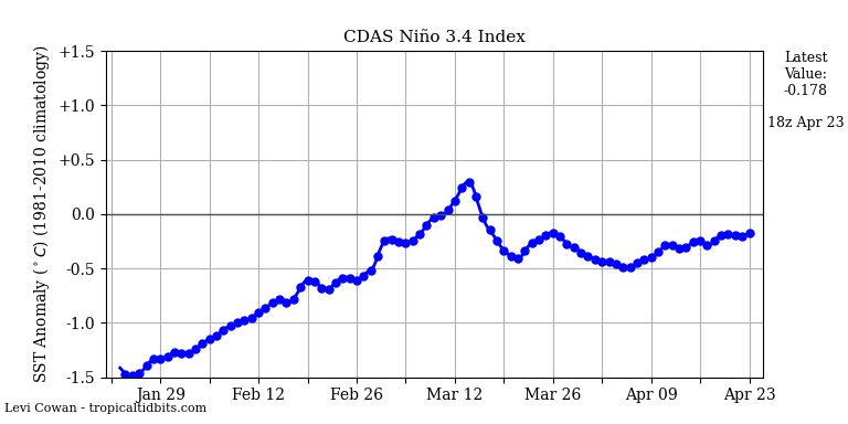
nino34.png


Also @N0mz if you go to this link and select "copy image address", and then use the "insert image" function "by url" you can have this image in your original post and it'll update in real time. That way anyone who comes into this thread can immediately see the current 3.4 index without having to leave the site.
Really anxious to see how this affects cool season severe weather . Can’t help think it will have effect on it due to the super strength of the Nino
 
Really anxious to see how this affects cool season severe weather . Can’t help think it will have effect on it due to the super strength of the Nino

Last Super El Nino winter (2015-'16) saw a couple of intense December tornado outbreaks (12/23 MS/TN and 12/26 TX).

Anyone remember the ENSO phase during December 2021 (12/10 and 12/15)? I seem to recall we were in neutral to weak La Nina during most of 2021-'22, but I'm not positive.
 
Last Super El Nino winter (2015-'16) saw a couple of intense December tornado outbreaks (12/23 MS/TN and 12/26 TX).

Anyone remember the ENSO phase during December 2021 (12/10 and 12/15)? I seem to recall we were in neutral to weak La Nina during most of 2021-'22, but I'm not positive.
Yeah it was a pretty consistent -1.0 or so
 
I had my biggest 24-hour total rainfall of 8.75 inches on December 25th, 2015
 

Attachments

  • Screenshot 2026-08-02 183902.png
    Screenshot 2026-08-02 183902.png
    45.3 KB · Views: 10
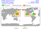
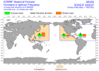
Don't know if anyone has mentioned this or not. But this is now a Central Pacific Modoki El Nino. The CANSIPS was giving hints this would happen months ago.
 
Interesting. What does it mean?
Well, in tropical land, this could lead to a more active Atlantic (2004) and hinder Pacific activity in some regard (you'll still have systems) And this is why the Euro might be onto something. Euro has above normal tropical storm frequency in East Pac, but take notice how far below normal hurricane/typhoon frequency it's showing across the Western Pacific. We'll see, but it perks my interest somewhat. Now granted the first storm in 2004 in the Atlantic didn't occur until August and we've already had 2 named storms (June and July). As I've learned over the years, not all ENSO's are the same nor have the same outcome.
 

Attachments

  • ps2png-worker-commands-5cd88d8c86-2xc5c-6fe5cac1a363ec1525f54343b6cc9fd8-3zgtctpo.png
    ps2png-worker-commands-5cd88d8c86-2xc5c-6fe5cac1a363ec1525f54343b6cc9fd8-3zgtctpo.png
    28.2 KB · Views: 4
  • ps2png-worker-commands-5cd88d8c86-pxqrt-6fe5cac1a363ec1525f54343b6cc9fd8-ro_nf_ad.png
    ps2png-worker-commands-5cd88d8c86-pxqrt-6fe5cac1a363ec1525f54343b6cc9fd8-ro_nf_ad.png
    28.3 KB · Views: 4
Last edited:
Back
Top