X
Xenesthis
Guest
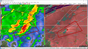
Well that looks bad for my area! I am just east of Murfreesboro
Follow along with the video below to see how to install our site as a web app on your home screen.
Note: This feature may not be available in some browsers.
Storm mode looks very strange.
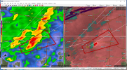
I mean, just not seeing anything discrete. Everything so far over north MS just looks like “junk” convection. You have to look back to north Louisiana to find anything that has the discrete look.Define "strange". You have my curiosity.
I mean, just not seeing anything discrete. Everything so far over north MS just looks like “junk” convection. You have to look back to north Louisiana to find anything that has the discrete look.
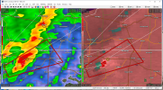
that storm near Corinth, MS needs a tornado warning right now
Possible developing Tornado near Corinth , MS per Nexrad