
I’d say this is the most likely explanation for this phenomenon.My best guess here was small pieces of wood torn from wood frame structure caused things like debarking. Stone/heavy brick is hard to accelerate into high speed to debark. Also brick/stone walls of masonry structure can serve us a shelter for vegatations nearby.
Damage features that can be seen from wood frame structures like rowing or granulation also seems much harder on masonry structures. These things make the comparsion of intensity between different areas more difficult.
Navigation
Install the app
How to install the app on iOS
Follow along with the video below to see how to install our site as a web app on your home screen.
Note: This feature may not be available in some browsers.
More options
-
Welcome to TalkWeather! We see you lurking around TalkWeather! Take the extra step and join us today to view attachments, see less ads and maybe even join the discussion. CLICK TO JOIN TALKWEATHER
You are using an out of date browser. It may not display this or other websites correctly.
You should upgrade or use an alternative browser.
You should upgrade or use an alternative browser.
Significant Tornado Events - Global Edition
- Thread starter atrainguy
- Start date
MNTornadoGuy
Member
Damage in Luzice. Large concrete buildings suffered severe superficial & roof damage. Trees were denuded, cars were thrown, and a metal factory was stripped.


Last edited:
Taranto tornado 2012 encountered some interesting DI in steel factory. One of them were cranes near the harboue and It lifted at least one of them. It seems to me that It was way more than "several tons" that claimed by an article.

 journals.ametsoc.org


An EF3 Multivortex Tornado over the Ionian Region: Is It Time for a Dedicated Warning System over Italy?
Abstract The possibility offered by the Internet to share pictures of tornadoes, and the storm-report archiving in the European Storm Weather Database, have made it apparent that the occurrence of tornadoes over Europe has been underestimated. Together with weak waterspouts and tornadoes, large...
MNTornadoGuy
Member
That tornado also caused waves when it was over water.Taranto tornado 2012 encountered some interesting DI in steel factory. One of them were cranes near the harboue and It lifted at least one of them. It seems to me that It was way more than "several tons" that claimed by an article.
View attachment 11934View attachment 11935An EF3 Multivortex Tornado over the Ionian Region: Is It Time for a Dedicated Warning System over Italy?
Abstract The possibility offered by the Internet to share pictures of tornadoes, and the storm-report archiving in the European Storm Weather Database, have made it apparent that the occurrence of tornadoes over Europe has been underestimated. Together with weak waterspouts and tornadoes, large...
MNTornadoGuy
Member
Last edited:
MNTornadoGuy
Member
MNTornadoGuy
Member
MNTornadoGuy
Member
The only F5 in the official Australian database is apparently the 1876 Bowen tornado. One person was killed and several others were in a "precarious state." Trees were "most carefully [de?]barked but not blown down." A school of arts, hospital, and multiple homes were reported to have been destroyed, some of which were completely leveled. The ground was reportedly "ploughed up in the track of the squall as if a grape and canister was fired." I can't find any newspaper reports of homes being completely swept away with the exception of this one possible description.Tornado ID,Date/Time,Latitude,Longitude,Nearest town,State,Fujita scale,Number of deaths,Comments,
1138,1876-02-22 00:00:00,-27.4679,153.0280,BRISBANE,QLD,F5,,22nd...BOWEN. Terrific tornado destroyed many houses. (On 26th 100 pounds was sent from Brisbane ).

gregassagraf
Member
Double waterspout with interesting vortex activity between them (maybe triple waterspout?), off the cost of Italy! Does any one know the specific location of this event?
gregassagraf
Member
Found a report from the tornado that hit Guaraciaba in the outbreak of 09/07/2009:
Apparently, a photo from a family that got their house leveled was found more than 150 kilometers (94 miles) away in the state of Rio Grande do Sul. That is one of the biggest statements about the power of these storms that affected Argentina and south Brazil that night!
Now that photo is part of an permanent exposition of the city museum about the tornado that affected a lot of communities in the city of Guaraciaba.
Last edited:
gregassagraf
Member
Here is a great presentation made by geographer Robert Dyer! He noticed some interesting features in satellite photographs made in the 60s and 70s of forest throughout the region encompassed by the states of Paraná, Santa Catarina and Rio Grande do Sul in Brazil, and the Provinces of Missiones, Corrientes, Entre Ríos and Buenos Aires in Argentina: various straight line forest clearings, some of which appeared out of nowhere in pictures with less than 1 year in difference. Some of them was as long as 70 km in length and as much as 2 km wide. Another feature noticed is that almost all of them were somewhat in parallel, towards the southeast direction. He than concluded that the only explanation to the phenomena were tornadoes! This is probably the first decent study about this type of event in Brazil.
(the presentation starts at minute 4:00 and ends at minute 9:34)
Also, you can find the presentation in article form in this PDF, which greatly eases the translation! (you can take a screenshot of the page and pass it to google translate which hopefully will give you a better sense of what is being said). The article starts at page 78 and ends at page 94.
Found a English written article from Robert Dyer that is a English version of the text mentioned above!
Here is the link:
MNTornadoGuy
Member
Found a report from the tornado that hit Guaraciaba in the outbreak of 09/07/2009:
Apparently, a photo from a family that got their house leveled was found more than 150 kilometers (94 miles) away in the state of Rio Grande do Sul. That is one of the biggest statements about the power of these storms that affected Argentina and south Brazil that night!
Now that photo is part of an permanent exposition of the city museum about the tornado that affected a lot of communities in the city of Guaraciaba.
That outbreak is probably the most violent in South American history alongside the 1959 one.
TH2002
Member
- Messages
- 4,973
- Reaction score
- 11,113
- Location
- California, United States
- Special Affiliations
- SKYWARN® Volunteer
Damage photos from the 31/7/2011 Blagoveshchensk, Russia tornado
Looks to have hit high F1/marginal F2 intensity

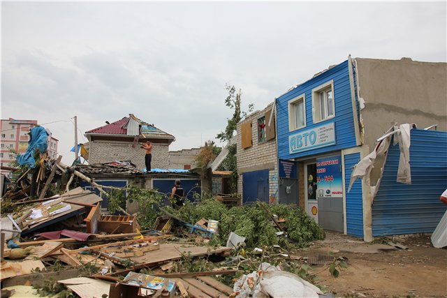
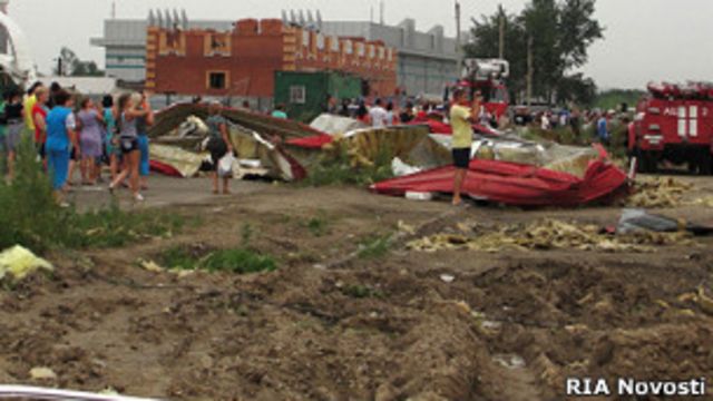
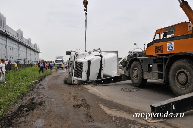
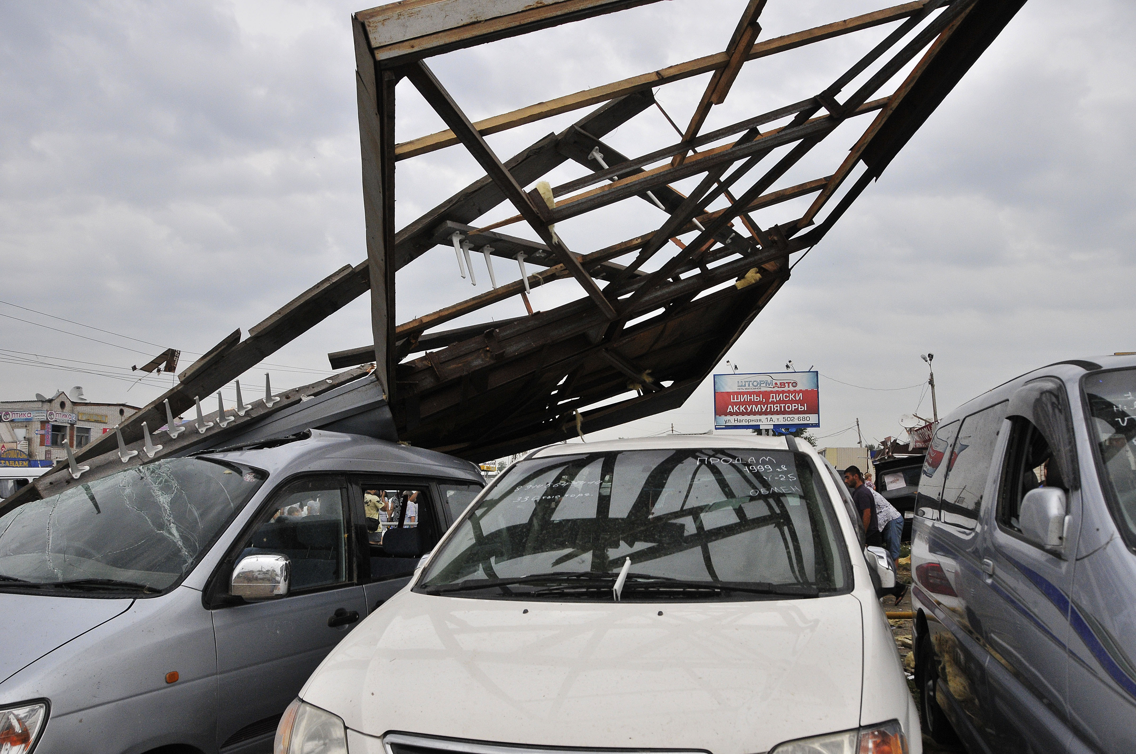
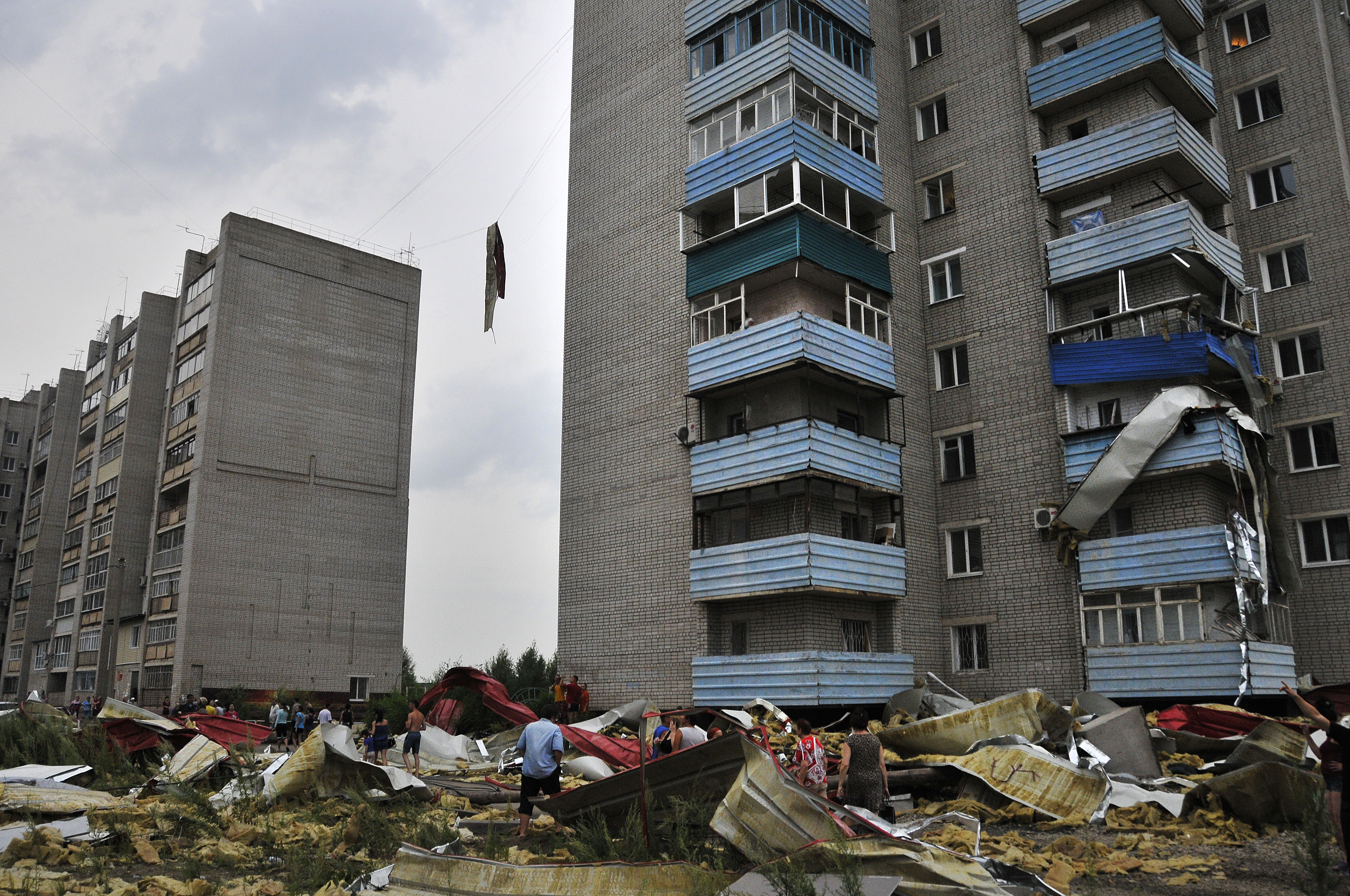
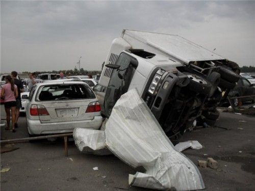
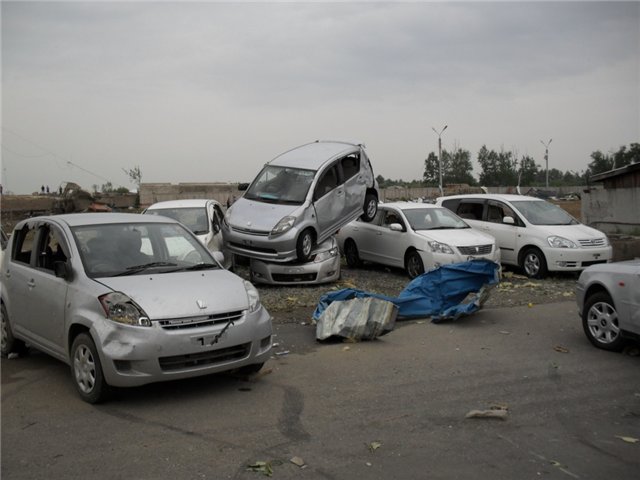
Looks to have hit high F1/marginal F2 intensity
MNTornadoGuy
Member
Still no rating for this thing? It was clearly violent.
MNTornadoGuy
Member
I think the precursor to the Guaraciaba tornado, the Misiones Argentina tornado was the strongest one of the outbreak. That tornado produced extreme tree damage with thousands of trees being mowed down and severely debarked. Also, satellite imagery shows that the Misiones tornado was clearly a different tornado.I have to agree! I wouldn’t be surprised if this tornado at times had wind speeds approaching the borderline of an EF5 tornado.
Since the damage that affected Missiones in Argentina (also rated, as the Guaraciaba storm as a F4), was caused by the same supercell, there is a great chance that this was one long track tornado. Because the lack of appropriate surveys, and the fact that the EF scale was never adapted and consolidated to the conditions in the region, severely interferes with true estimates of wind speeds and identification of such events.
For example, because most building codes in Brazil puts a minimum wind speeds that the structure needs to sustain at about 150 km/h, when such structures get obliterated they rate the tornado as having wind speeds of that sort! This severely dampens the awareness about these types of events. Like the Guaraciaba tornado that was initially reported to have winds speeds between 120-180 km/h even though it managed to level several homes; throw an entire house about 80 yards away from its foundation, not only that but the house landed over a hill, which probably increases the damage indicator; and also throw debris almost 100 miles away from their origins.
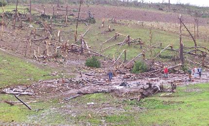
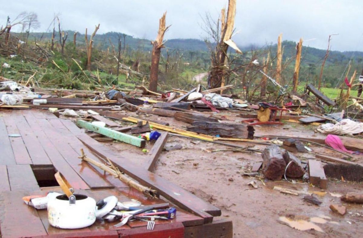


That vegetation damage is pretty high-end. Clearly a very violent tornado.I think the precursor to the Guaraciaba tornado, the Misiones Argentina tornado was the strongest one of the outbreak. That tornado produced extreme tree damage with thousands of trees being mowed down and severely debarked. Also, satellite imagery shows that the Misiones tornado was clearly a different tornado.
MNTornadoGuy
Member
MNTornadoGuy
Member
gregassagraf
Member
Wow! I thought they were produced by the same storm because Guaraciaba is about 30 miles away from where the damage in Argentina occurred. And yes, the tree damage in these photos are impressive! The second one has incredible leves of debarking.I think the precursor to the Guaraciaba tornado, the Misiones Argentina tornado was the strongest one of the outbreak. That tornado produced extreme tree damage with thousands of trees being mowed down and severely debarked. Also, satellite imagery shows that the Misiones tornado was clearly a different tornado.
In regards to my quoted post I decided to delete it because I speculated too much specially with the EF5 winds statement I made. But I’ve read multiple times that both tornadoes were produced by the same supercell.
But I can confirm that a lot of tornadoes in the region are extremely underrated! Like the one that devastated communities in the municipality of Muitos Capões, in Rio Grande do Sul, back in 2005: it was only rated as an F2, but considering that it leveled brick masonry constructions, it was definitely an EF3+!


Another underrated tornado in south Brazil was the one that devastated the town of Nova Laranjeiras back in 1997! This tornado produces some incredible damage, and maybe it was the strongest tornado of the 1990s in the region! According to news sources at the time, it managed to throw a Beetle (car) more than 160 yards away from where it was originally.