
Navigation
Install the app
How to install the app on iOS
Follow along with the video below to see how to install our site as a web app on your home screen.
Note: This feature may not be available in some browsers.
More options
-
Welcome to TalkWeather! We see you lurking around TalkWeather! Take the extra step and join us today to view attachments, see less ads and maybe even join the discussion. CLICK TO JOIN TALKWEATHER
You are using an out of date browser. It may not display this or other websites correctly.
You should upgrade or use an alternative browser.
You should upgrade or use an alternative browser.
Severe WX Severe Wx Outbreak March 1st- 3rd, 2023 - Southern States, MS/OH/TN Valley
- Thread starter KevinH
- Start date
OHWX97
Member
These were really some impressive looking tornadoes in southwest Ohio.
These were really some impressive looking tornadoes in southwest Ohio.
Ohio is on a roll with the photogenic tornadoes recently, from June 8 last year, then Monday's event, and now today.
Argus
Member
And the storm arrived at 652pm
Equus
Member
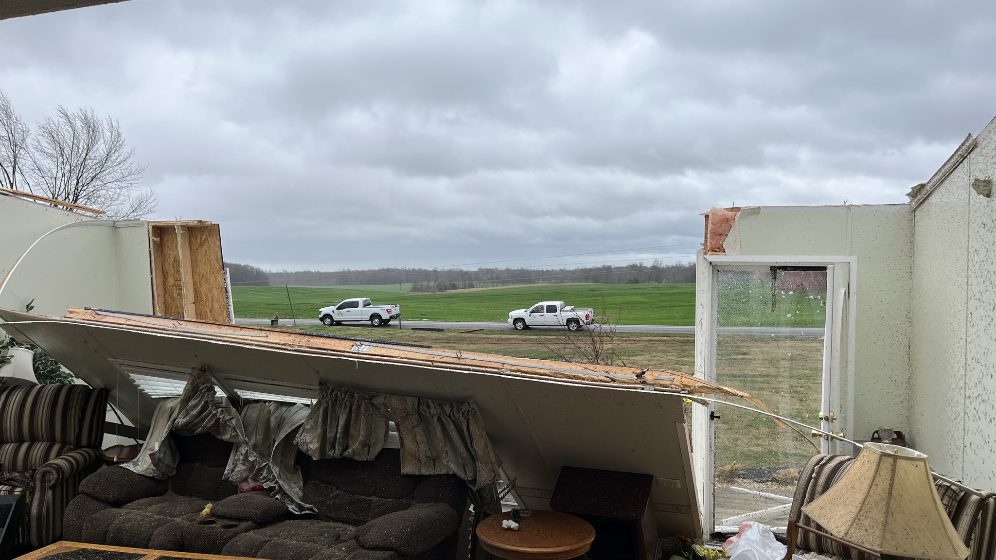
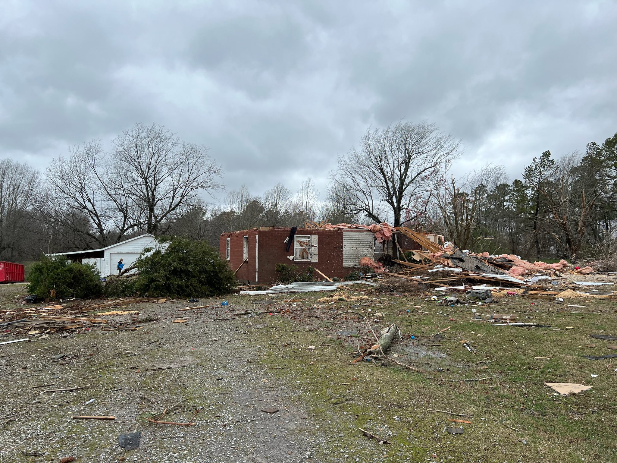
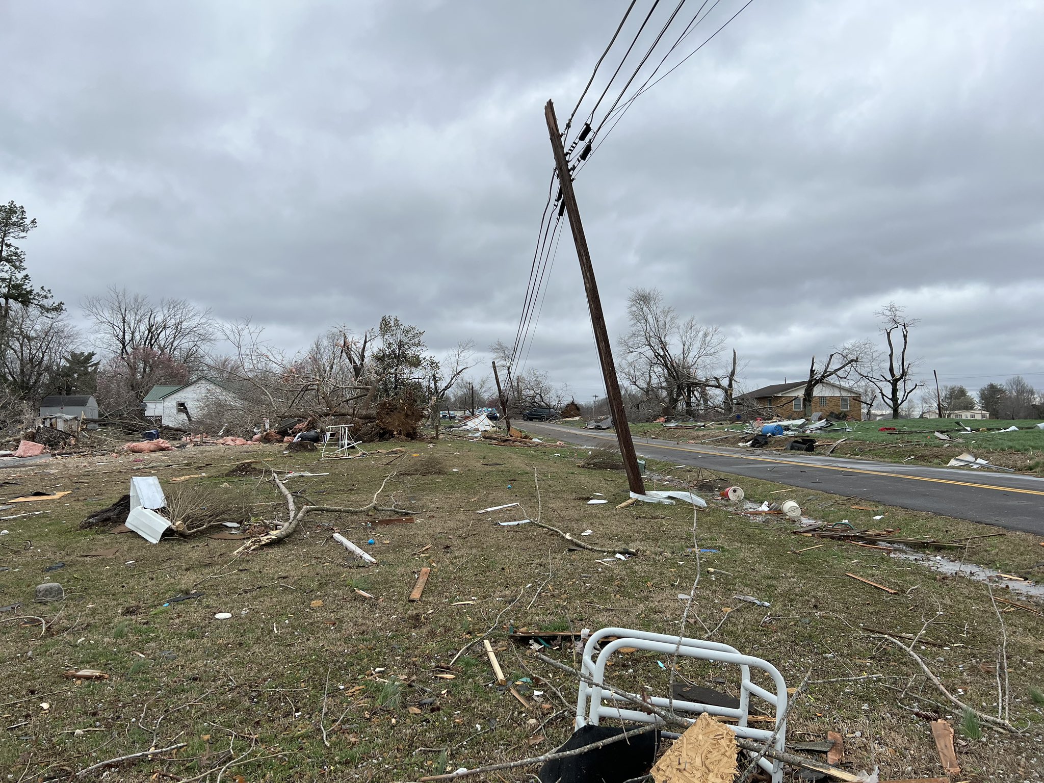
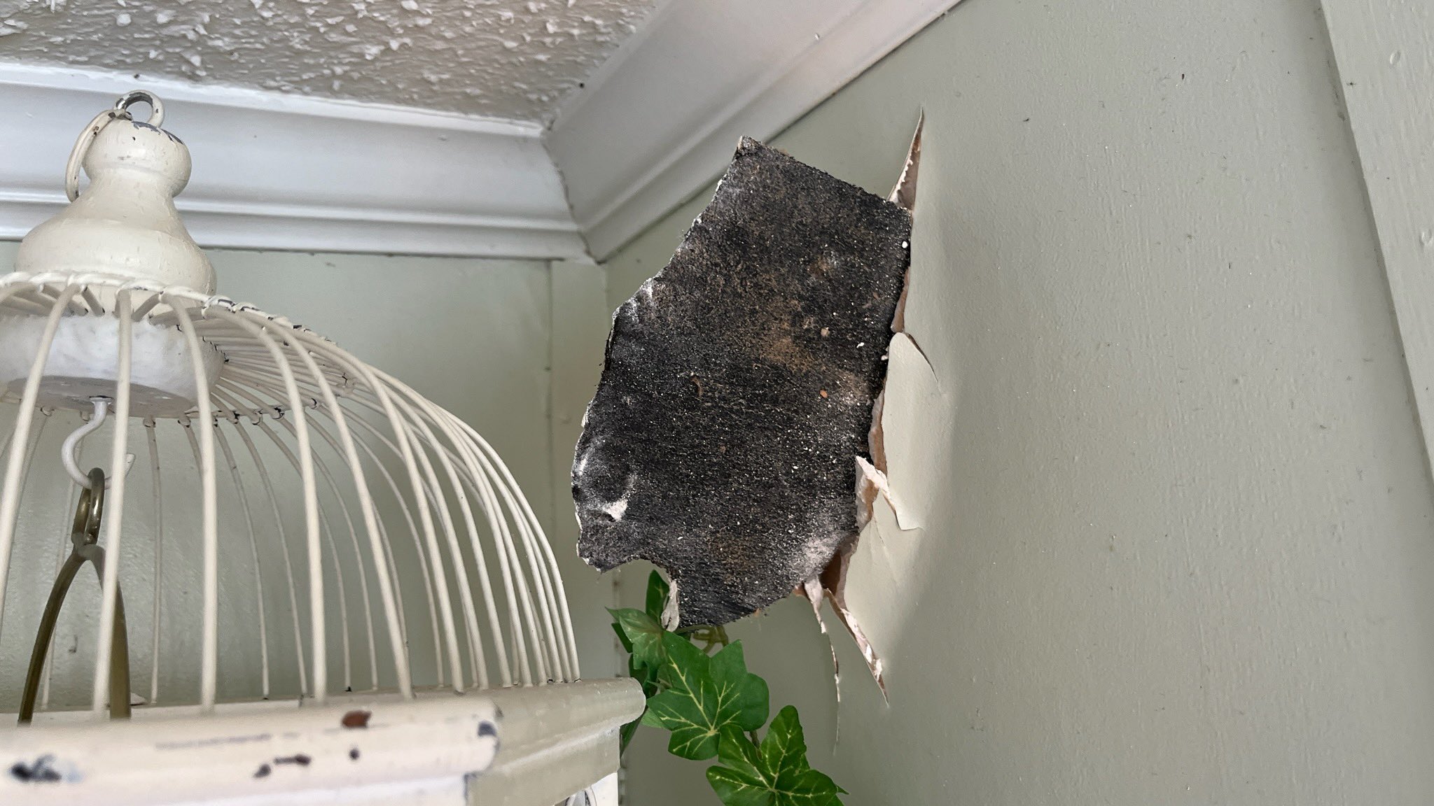
Power is still out here with no ETA, massive outages all across NW AL, this happened a few hundred yards away from the house at about 11:10; got a video of 60-70mph winds at home but can't post without internet lol


If anyone has a radar shot from GWX from 11:10am, please share as my phone broke and I have lost months of photos and radar imagery rip
If anyone has a radar shot from GWX from 11:10am, please share as my phone broke and I have lost months of photos and radar imagery rip
OHWX97
Member
On a bit of side note, southern Michigan, as well as northern Indiana are currently being pounded by a major snowstorm. My sister, who lives in Ann Arbor, is experiencing frequent thundersnow and high snowfall rates. This has been an insanely dynamic storm system, producing a plethora of different hazards.

Mesoscale Discussion 0251
NWS Storm Prediction Center Norman OK
0425 PM CST Fri Mar 03 2023
Areas affected...Northern Indiana and southern Lower Michigan
Concerning...Heavy snow
Valid 032225Z - 040230Z
SUMMARY...Strong ascent across the northern Indiana and southern
Lower Michigan region, coupled with areas of freezing temperatures
at the surface, will support pockets of heavy snowfall rates through
mid evening.
DISCUSSION...Over the past 1-2 hours, a handful of surface
observations from far northeast IL, northern IN, and southern Lower
MI have reported moderate to heavy snowfall with visibility at or
below 1/4 mile at times. Such conditions have largely been contained
to areas where surface temperatures have experienced strong
evaporative cooling and fallen into the 30-32 F range. Many
locations that are currently above freezing are reporting dewpoint
values in the low 30s, suggesting that additional low-level
evaporative cooling to freezing is possible over the next few hours
- especially under areas of heavier precipitation. Aloft, strong
isentropic ascent through the 925-700 mb layer will be augmented by
a mid-level deformation zone to the north of the synoptic low. This
ascent is expected to persist through the late afternoon/evening
hours as a strong cyclone lifts to the northeast, and may promote
periods of organized snow banding. Furthermore, periodic lightning
flashes suggest adequate buoyancy exists over the region to support
localized bursts of heavier snow. Consequently, snowfall rates up to
2 inches/hour (possibly as high as 3 inches/hour) will be possible
where low-level temperatures are below freezing.
..Moore.. 03/03/2023
Last edited:
Equus
Member
Video up
Timhsv
Member
With such prominent soundings on Friday and severe indices actually observed on the SPC Meso site, I will be keenly interested as to why there wasn't an actual tornado outbreak on a high end scale. The values on Friday by 18Z were almost outrageous. Was it actually the warm nose at 600mb? or was it due to so much wind shear, it tore apart most updrafts?
Equus
Member
Power's been out now for 15 hours - that's the longest outage at home I can think of since 4/27/11; expected some trees and lines down but the extent of this power outage is pretty impressive. ETA on service restoration is Sunday evening, but of course that's more of a latest possible estimation.
In the 40s tonight, so the Norfolk Island pines and gecko come in the house where it is warmer
In the 40s tonight, so the Norfolk Island pines and gecko come in the house where it is warmer
Seems like the strong cap played a role. Atmospheric conditions really killed off any cells that even tried to develop in front of the main line, and updrafts that formed within the QLCS got shredded as soon as they took shape.With such prominent soundings on Friday and severe indices actually observed on the SPC Meso site, I will be keenly interested as to why there wasn't an actual tornado outbreak on a high end scale. The values on Friday by 18Z were almost outrageous. Was it actually the warm nose at 600mb? or was it due to so much wind shear, it tore apart most updrafts?
Equus
Member
Power has returned 28 hours later, quite the extended outage for here
Timhsv
Member
I noticed this on Friday's SPC Meso Page and it was the first time I've seen EF4 Probs

I noticed this on Friday's SPC Meso Page and it was the first time I've seen EF4 Probs
View attachment 18591
I've known of them for quite some time now, and it's one of the parameters that I will check on the mesoanalysis page (but then again, I have a tendency to check ALL of the available parameters on that page when I get a chance to do so anyway).
Equus
Member
Not sure about everyone else but I love getting into the post-mortem of an event and trying to discover why it did or did not perform as expected; now that the power's on, new phone is set up, and have a few minutes to look at stuff, it's interesting to dive in and see what we have via RAP and soundings...
It really does seem as though the combination of the warm nose aloft and extreme shear killed any prospective supercell updrafts across the AL/TN/GA corridor and will try to dive into why; major apologies if anyone else wished to also do so, feel free to still do that, more analysis is great
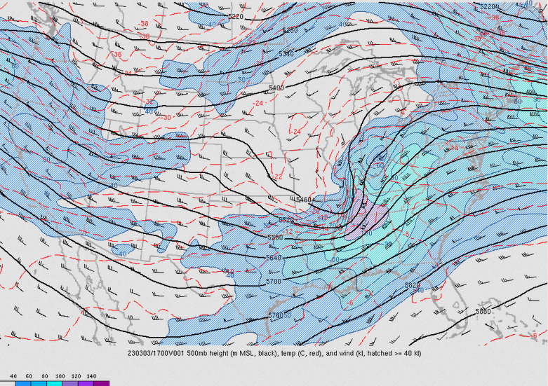
110kt flow at 500mb is absolutely insane; having that level of dynamics in the MS/AL/TN tristate area on the east side of the shortwave is in the very upper echelon of events here and we just don't see that very often - by all rights this should have been sufficient for a very upper end outbreak. This leads to bulk shear of 90kt and effective SRH of 600m²s² across parts of north AL by midday! Obscene dynamics in play
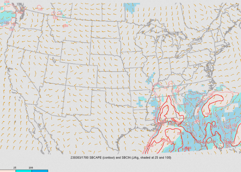
Usually in an environment of such extreme mid level flow, there isn't instability present, but surface CAPE was not absent on 3/3 - values of 500-1500 j/kg in fact were in place across the warm sector from central TN southward; on the surface this surface CAPE and such extreme shear would be extremely potent! However there was one additional factor...

The mid level warm nose is extremely evident on the RAP map of mid level lapse rates; values below 6 over nearly all of AL and GA indicate that updrafts would struggle massively upon reaching the 700-500mb level and vertical acceleration would become very poor in the warm air aloft. Updrafts that struggle with vertical acceleration also seem to struggle heavily in excessively high shear; the notion that weak updrafts are 'torn apart' by high shear while probably more nuanced than that by way of physics seems pretty accurate in the broader mechanics of things. Recall that we have 80-90kt of bulk shear and 400-600 m²s² of effective helicity in the vicinity of these horrible lapse rates; a weak and decelerating updraft dealing with category two hurricane levels of shear aloft. Supercells and tornadoes are surprisingly fragile and rely on subtle environments; the dynamics in play brought nuclear bombs to a knife fight
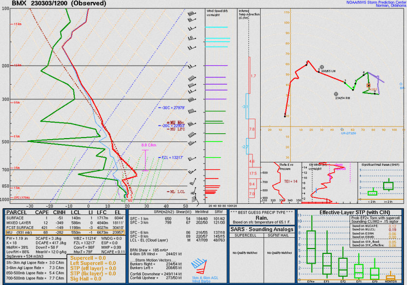
The morning sounding from BMX shows the insane dynamics but the warm air aloft in the form of a very strong cap is evident
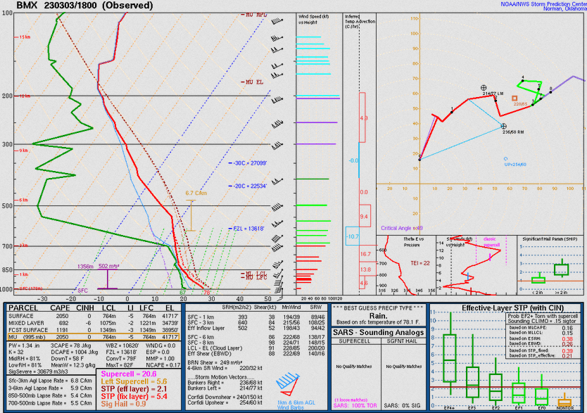
The special 18z sounding, right before the QLCS hit BMX, shows that advection and sun had dramatically modified the surface profile with steep lapse rates in the lowest 1km, but look at that profile from 1km to 5km; the warm nose is still definitely present and lapse rates above the lowest 1km are terrible. Not to mention the mixing has kept the LCLs very high, above what one would prefer to see for supercell tornadoes. Wind profiles are still very strong but despite better surface thermos, the mid-levels tell the story - the strongly forced QLCS cares little for the meager lapse rates, but warm sector development relies extremely heavily upon it; the warm nose removed any chances of updrafts getting going ahead of the line, promising struggling weak vertical motion that gets sheared apart by the extreme shear present.
Thus, despite 78/67 and nearly 400 m²s² of 0-1km SRH - values which should indicate an extreme tornado outbreak! - the mid-levels tell the story, and provide the fine line between a QLCS day and a violent warm sector supercell outbreak
It really does seem as though the combination of the warm nose aloft and extreme shear killed any prospective supercell updrafts across the AL/TN/GA corridor and will try to dive into why; major apologies if anyone else wished to also do so, feel free to still do that, more analysis is great
110kt flow at 500mb is absolutely insane; having that level of dynamics in the MS/AL/TN tristate area on the east side of the shortwave is in the very upper echelon of events here and we just don't see that very often - by all rights this should have been sufficient for a very upper end outbreak. This leads to bulk shear of 90kt and effective SRH of 600m²s² across parts of north AL by midday! Obscene dynamics in play
Usually in an environment of such extreme mid level flow, there isn't instability present, but surface CAPE was not absent on 3/3 - values of 500-1500 j/kg in fact were in place across the warm sector from central TN southward; on the surface this surface CAPE and such extreme shear would be extremely potent! However there was one additional factor...
The mid level warm nose is extremely evident on the RAP map of mid level lapse rates; values below 6 over nearly all of AL and GA indicate that updrafts would struggle massively upon reaching the 700-500mb level and vertical acceleration would become very poor in the warm air aloft. Updrafts that struggle with vertical acceleration also seem to struggle heavily in excessively high shear; the notion that weak updrafts are 'torn apart' by high shear while probably more nuanced than that by way of physics seems pretty accurate in the broader mechanics of things. Recall that we have 80-90kt of bulk shear and 400-600 m²s² of effective helicity in the vicinity of these horrible lapse rates; a weak and decelerating updraft dealing with category two hurricane levels of shear aloft. Supercells and tornadoes are surprisingly fragile and rely on subtle environments; the dynamics in play brought nuclear bombs to a knife fight
The morning sounding from BMX shows the insane dynamics but the warm air aloft in the form of a very strong cap is evident
The special 18z sounding, right before the QLCS hit BMX, shows that advection and sun had dramatically modified the surface profile with steep lapse rates in the lowest 1km, but look at that profile from 1km to 5km; the warm nose is still definitely present and lapse rates above the lowest 1km are terrible. Not to mention the mixing has kept the LCLs very high, above what one would prefer to see for supercell tornadoes. Wind profiles are still very strong but despite better surface thermos, the mid-levels tell the story - the strongly forced QLCS cares little for the meager lapse rates, but warm sector development relies extremely heavily upon it; the warm nose removed any chances of updrafts getting going ahead of the line, promising struggling weak vertical motion that gets sheared apart by the extreme shear present.
Thus, despite 78/67 and nearly 400 m²s² of 0-1km SRH - values which should indicate an extreme tornado outbreak! - the mid-levels tell the story, and provide the fine line between a QLCS day and a violent warm sector supercell outbreak
Sawmaster
Member
I feel for you- my laptop died suddenly 3 days ago, but about all I lost was bookmarks as I've gotten in the habit of using online storgage and back-up for anything important.Power is still out here with no ETA, massive outages all across NW AL, this happened a few hundred yards away from the house at about 11:10; got a video of 60-70mph winds at home but can't post without internet lol
View attachment 18574
If anyone has a radar shot from GWX from 11:10am, please share as my phone broke and I have lost months of photos and radar imagery rip
- Thread starter
- #1,738
KevinH
Member
Hope everyone is safe!
warneagle
Member
Kind of unnerving to see how close we were to probably one of the bigger events of the last few years and how minor of a feature was the saving grace. Reminds me of that time the Air Force accidentally dropped a nuclear bomb in North Carolina and one switch kept it from exploding. On the other hand though, it's a testament to how perfect things have to be for truly high-end events and why they're so rare.
The NWS office in Nashville has a page up about the top ten highest and lowest pressure readings taken at Nashville. The March 3 pressure reading is now the third lowest on record for the city:
