- Moderator
- #1,081
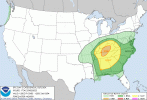
And this to go with that may end up being ugly.If you get a cell or two riding the warm front up in southern Arkansas where the shear would be enhanced you could get a sigtor threat there but yeah the open warm sector doesn't really look like it's going to amount to much.
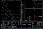
I'm not sure why a parameter space like this isn't producing any convection but yeah. LLLRs aren't great but there isn't much capping to speak of. Seems like it should produce storms, and yet.