
Navigation
Install the app
How to install the app on iOS
Follow along with the video below to see how to install our site as a web app on your home screen.
Note: This feature may not be available in some browsers.
More options
-
Welcome to TalkWeather! We see you lurking around TalkWeather! Take the extra step and join us today to view attachments, see less ads and maybe even join the discussion. CLICK TO JOIN TALKWEATHER
You are using an out of date browser. It may not display this or other websites correctly.
You should upgrade or use an alternative browser.
You should upgrade or use an alternative browser.
Severe WX Severe Wx Outbreak March 1st- 3rd, 2023 - Southern States, MS/OH/TN Valley
- Thread starter KevinH
- Start date
Been awhile since I've seen a maxed out updrafts swath 
 Some healthy cells near Shreveport growing, they'll probably end up being your trouble makers here in the future. Whether they go tornadic who knows lol, very weak and broad rotation now if any
Mesocyclone on the storm near vandervoort Arkansas keeps strengthening with each frame 
Mesocyclone on the storm near vandervoort Arkansas keeps strengthening with each frame
It looks to have weakened somewhat on the most recent couple of scans.
- Moderator
- #786
Mesocyclone on the storm near vandervoort Arkansas keeps strengthening with each frame View attachment 18414
Yep and that’s a clean look to its south. May go crazy.
Yep and that’s a clean look to its south. May go crazy.
It's already bowing out. With that fairly fast motion (46 knots, according to the newest warning on it), I wouldn't be surprised if this thing ends up reaching (mini(?)-)derecho status before too long.
s
Got a large hail core on itIt's already bowing out. With that fairly fast motion (46 knots, according to the newest warning on it), I wouldn't be surprised if this thing ends up reaching (mini(?)-)derecho status before too long.
Supercell northeast of Shreveport has finally shedded off some of the merging and interference been trying to get some robust rotation but has been hindered seems to be good now.
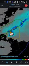
Big ole hail core
GR2AE's Maximum Expected Hail Size (MEHS) setting suggests a hail size of up to around 2.96 inches in that core.
Good grief man. Lol that's some gorilla hail. wait gorilla hail is larger than that hahahGR2AE's Maximum Expected Hail Size (MEHS) setting suggests a hail size of up to around 2.96 inches in that core.
TornadoFan
Member
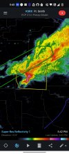
That Mount Ida, AR storm sure is trying to get it together.
Check out the reflectivity spikes that's indicative of very large hail on radar. Massive hail in that storm 
TornadoFan
Member
Rotation on it is pretty broad at the moment.
Rotation on it is pretty broad at the moment.
That despite it curling up into a classic hook shape.
And now it has a tornado warning on it:
362
WFUS54 KLZK 012353
TORLZK
ARC051-059-097-125-020045-
/O.NEW.KLZK.TO.W.0021.230301T2353Z-230302T0045Z/
BULLETIN - EAS ACTIVATION REQUESTED
Tornado Warning
National Weather Service Little Rock AR
553 PM CST Wed Mar 1 2023
The National Weather Service in Little Rock has issued a
* Tornado Warning for...
Garland County in central Arkansas...
West central Saline County in central Arkansas...
Southeastern Montgomery County in western Arkansas...
Northeastern Hot Spring County in southwestern Arkansas...
* Until 645 PM CST.
* At 552 PM CST, a severe thunderstorm capable of producing a
tornado was located near Mount Ida, moving east at 60 mph. This
storm has a history of producing up to two inch hail as well, most
recently in Mount Ida.
HAZARD...Tornado and hail up to two inches in diameter.
SOURCE...Radar indicated rotation.
IMPACT...Flying debris will be dangerous to those caught without
shelter. Mobile homes will be damaged or destroyed.
Damage to roofs, windows, and vehicles will occur. Tree
damage is likely.
* Locations impacted include...
Hot Springs... Hot Springs Village...
Mount Ida... Mountain Pine...
Lonsdale... Hot Springs Memorial Field...
Meyers... Jessieville...
Lake Ouachita State Park... Rockwell...
Hot Springs National Park... Mauldin...
Avant... Magnet Cove...
Oaklawn Racetrack... Sunshine...
Royal... Lena Landing Rec Area...
Gulpha Gorge... Hempwallace...
PRECAUTIONARY/PREPAREDNESS ACTIONS...
TAKE COVER NOW! Move to a basement or an interior room on the lowest
floor of a sturdy building. Avoid windows. If you are outdoors, in a
mobile home, or in a vehicle, move to the closest substantial shelter
and protect yourself from flying debris.
&&
LAT...LON 3440 9361 3448 9367 3459 9367 3476 9285
3443 9280
TIME...MOT...LOC 2352Z 261DEG 51KT 3450 9355
TORNADO...RADAR INDICATED
MAX HAIL SIZE...2.00 IN
$$
72
TornadoFan
Member
And it just went tornado warned.
Its been fairly tame so far, LLJ will probably be strengthening here soon so I'd watch for a uptick. Hopefully not but its probably inevitable
Let's hope this is not a repeat of the tornado emergency situation from a couple years ago that was just a scud cloud.
Looks like there's no tight rotation. Is there any ground truth?
Looks like there's no tight rotation. Is there any ground truth?