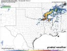
Looking at the start of the newest run the updrafts swaths are crazy three major supercells moving into Arkansas in the next 3 hours.
Follow along with the video below to see how to install our site as a web app on your home screen.
Note: This feature may not be available in some browsers.
Looking at the start of the newest run the updrafts swaths are crazy three major supercells moving into Arkansas in the next 3 hours.View attachment 18405

It's likely due to the warm mid level temperatures -> i.e. storm growth is stunted due to weak instability in this layer and you get a lack of robust convection.What I find interesting is that despite those ridiculous ingredients, neither than 3kNAM nor HRRRR (at the extreme end of its range admittedly) are showing much in the way of updraft helicity.


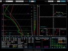
What's the probs?View attachment 18408
URGENT - IMMEDIATE BROADCAST REQUESTED
Tornado Watch Number 50
NWS Storm Prediction Center Norman OK
330 PM CST Wed Mar 1 2023
The NWS Storm Prediction Center has issued a
* Tornado Watch for portions of
Central and southern Arkansas
Northern Mississippi
Extreme southeast Oklahoma
Southwest Tennessee
Northeast Texas
* Effective this Wednesday afternoon and evening from 330 PM
until 1000 PM CST.
* Primary threats include...
A few tornadoes likely with a couple intense tornadoes possible
Scattered large hail likely with isolated very large hail events
to 3 inches in diameter possible
Scattered damaging wind gusts to 70 mph likely
SUMMARY...Storms should increase and coverage and intensity this
afternoon and evening, with a threat for large hail, damaging winds
and a few tornadoes.
The tornado watch area is approximately along and 75 statute miles
north and south of a line from 50 miles northeast of Tupelo MS to 45
miles southwest of De Queen AR. For a complete depiction of the
watch see the associated watch outline update (WOUS64 KWNS WOU0).
PRECAUTIONARY/PREPAREDNESS ACTIONS...
REMEMBER...A Tornado Watch means conditions are favorable for
tornadoes and severe thunderstorms in and close to the watch
area. Persons in these areas should be on the lookout for
threatening weather conditions and listen for later statements
and possible warnings.
&&
AVIATION...Tornadoes and a few severe thunderstorms with hail
surface and aloft to 3 inches. Extreme turbulence and surface wind
gusts to 60 knots. A few cumulonimbi with maximum tops to 500. Mean
storm motion vector 25035.
I'm slow todayWhat's the probs?
Your good that's me everyday lolI'm slow today

Wheres that? Arkansas?Does anyone mind giving me a hodograph of Broken Bow? My mom’s coworker lives there
Just NE of Idabel, OK.Wheres that? Arkansas?
Not much it'll be about 5-6 hours before anything over there could get going. It'll probably be more of a MCS by thenCells popping up in the Mississippi Delta south of Memphis. Is there any twist in the atmosphere there?