
yep and sometimes the more underrated threat. Because flooding is not as sexy per se as tornadoes.Flooding often manages to be the sneaky threat with a lot of these systems.
Navigation
Install the app
How to install the app on iOS
Follow along with the video below to see how to install our site as a web app on your home screen.
Note: This feature may not be available in some browsers.
More options
-
Welcome to TalkWeather! We see you lurking around TalkWeather! Take the extra step and join us today to view attachments, see less ads and maybe even join the discussion. CLICK TO JOIN TALKWEATHER
You are using an out of date browser. It may not display this or other websites correctly.
You should upgrade or use an alternative browser.
You should upgrade or use an alternative browser.
Severe WX Severe Wx Outbreak March 1st- 3rd, 2023 - Southern States, MS/OH/TN Valley
- Thread starter KevinH
- Start date
Austin Dawg
Member
Come over to Texas. We've got room. Just stay away from the borderNo where far, just down the road to something smaller
From Patreon: Good Evening! A lot to go over so let's start. A multi-day significant to major severe weather/tornado outbreak is expected starting late tomorrow and going through Friday. The 00z HRRR future radar is valid from 5pm tomorrow through 6pm Thursday.
Round #1 (Tomorrow through Thursday):
Storm Timing: 5pm tomorrow through 6pm Thursday
A severe weather risk is expected tomorrow through Thursday. Primary Threats: damaging winds to 60mph and large hail up to 2 inches (Hen Egg). A isolated tornado is possible.
Round #2 (Late Thursday night through early Friday afternoon):
Storm Timing: Midnight through 1pm Friday
A very significant to major severe weather/tornado outbreak is expected during the early morning through early afternoon hours of Friday. Primary Threats: quarter size hail, damaging winds to 70mph, and tornadoes (some strong).
In addition, heavy rainfall of 2 to 4 inches (locally 4+) are expected especially if storms train over the same areas. Scattered to possibly numerous flash flooding would be likely. The current Flood Watch for parts of the Mid-South region may be expanded southward into more of North MS.
The fact that the main potential for significant severe weather/tornadoes is during the nighttime hours is of great concern. Please have various ways to stay weather alert.
Attachments

MattW
Member
- Messages
- 388
- Reaction score
- 382
- Location
- Decatur, GA
- HAM Callsign
- KG4GUF
- Special Affiliations
- SKYWARN® Volunteer
The models are all over the place. It seems the NAM is more north of Atlanta, the GFS is south (but maybe trending north with ensemble support) while the Euro, UK, and Canadian models basically say "everyone gets a tornado." SREF centers the threat on Atlanta. I'm about to lose what's left of my mind trying to figure this one out.
Timhsv
Member
Concerning for Wednesday evening from 00Z. Then more concerning for Friday?


Last edited:
TornadoFan
Member
SPC is keeping tomorrow at a slight risk as of 0600Z.


tornado examiner
Member
Moderate risk issued with all hazards being having hatched outlines


Last edited:
tornado examiner
Member
Is there any possibility they issue a high risk?
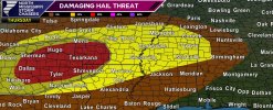
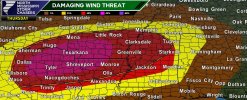
Hail and Wind Threats for Thursday:
Attachments
Surprised at the maintaining of a slight for todays threat
Bevo
Member
Based on the models for today/Thursday, I really need to invest in one of those car hail shields like yesterday…having lived here so long in DFW it’s crazy to me how very little shelter options there are for vehicles outside of having your own garage.
Scheduled to have to stay late at work tomorrow too. I don’t suppose we will get much turnout at the open house at school…and it’s somewhat concerning thinking about sheltering plans with whoever does show up at the building. I’m not sure the district is going to end up cancelling for weather. Honestly, this system is one of the larger threats I’ve seen for the DFW metro in quite some time.
Scheduled to have to stay late at work tomorrow too. I don’t suppose we will get much turnout at the open house at school…and it’s somewhat concerning thinking about sheltering plans with whoever does show up at the building. I’m not sure the district is going to end up cancelling for weather. Honestly, this system is one of the larger threats I’ve seen for the DFW metro in quite some time.
CheeselandSkies
Member
06Z HRRR rakes southern Arkansas with supercells Thursday evening...in line with thinking based on the forecast environment there over the last several days.
Casuarina Head
Member
From Andy.
Wouldn’t the occlusion tend to temper the high-end tornado risk on Friday?
Yes, would decrease low level shear plus decrease low level instabilityWouldn’t the occlusion tend to temper the high-end tornado risk on Friday?
Yeah I was looking at that, it has some crossing over one another in south Arkansas, awaiting NWS of Fayetteville new discussion06Z HRRR rakes southern Arkansas with supercells Thursday evening...in line with thinking based on the forecast environment there over the last several days.
Casuarina Head
Member
This is definitely good news, though not entirely surprising. Just a few days ago modelling was showing a broad-based trough and concomitantly a significant tornado threat on Friday. However, as has been often the case in recent years, within the short term modelling rapidly trended toward a more amplified, occluded solution. This further justifies my earlier caution about the potential “ceiling” for this event in terms of multiple EF2+ tornado families. The occlusion might also help constrict the severe-wind threat to some extent as well, which is also good news. In fact the severe-wind threat looks to be less than I expected just a day or so ago. The large-scale synoptics on the models would need to change significantly today and tomorrow in order for Friday to end up being much more significant.Yes, would decrease low level shear plus decrease low level instability
we are now approaching the timeframe that models should getting a better idea if there is an occlusion. I have seen some hints, such as the very round isobars and the slower movement of the surface low. Right now, models are suggestion the occlusion doesn't happen, but I know this kind of setup usually leads to one...we shall seeThis is definitely good news, though not entirely surprising. Just a few days ago modelling was showing a broad-based trough and concomitantly a significant tornado threat on Friday. However, as has been often the case in recent years, within the short term modelling rapidly trended toward a more amplified, occluded solution. This further justifies my earlier caution about the potential “ceiling” for this event in terms of multiple EF2+ tornado families. The occlusion might also help constrict the severe-wind threat to some extent as well, which is also good news. In fact the severe-wind threat looks to be less than I expected just a day or so ago. The large-scale synoptics on the models would need to change significantly today and tomorrow in order for Friday to end up being much more significant.