- Thread starter
- #201
Navigation
Install the app
How to install the app on iOS
Follow along with the video below to see how to install our site as a web app on your home screen.
Note: This feature may not be available in some browsers.
More options
-
Welcome to TalkWeather! We see you lurking around TalkWeather! Take the extra step and join us today to view attachments, see less ads and maybe even join the discussion. CLICK TO JOIN TALKWEATHER
You are using an out of date browser. It may not display this or other websites correctly.
You should upgrade or use an alternative browser.
You should upgrade or use an alternative browser.
Severe Weather Threat - October 18th/19th 2025
- Thread starter WeathermanLeprechaun
- Start date
KakashiHatake2000
Member
mississippi live weather has eyes and coverage on it
joshoctober16
Member
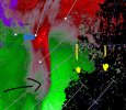
perhaps this is a example of a fully ground up tornado formation?Probable debris is co-located with a rearward area of negative NROT values. Only real explanation that comes to mind is a large or multi-vortex tornado or chaotic meso-handoff that has resulted in the unusual radar presentation. Very odd.
View attachment 47565
there was no velocity on the first scan but on the third scan there was a clear velocity area.
Central Ohio Wx
Member
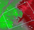
Probably a brief spin-up; that CC drop could have been caused by fallen leaves and other stuff just laying around. It’s lifted now.View attachment 47557
Horrible news.
Reviewing radar scans, it looks like a tornado formed and then got split off from the parent mesocyclone. Both appeared to have since fizzled.perhaps this is a example of a fully ground up tornado formation?
there was no velocity on the first scan but on the third scan there was a clear velocity area.
joshoctober16
Member
it took a right turn before hitting downtown , while this happend a meso with no tornado seem to went into downtown.Probably a brief spin-up; that CC drop could have been caused by fallen leaves and other stuff just laying around. It’s lifted now.
- Thread starter
- #207
WeathermanLeprechaun
Member
Sorry, i didnt see your message due to the tornado in Yazoo. I appreciate it and will probably head to bed in the next few minutes UNLESS this does something else which I hope it doesn'tnight weather man leprechaun have a good one and enjoy the peaceful rain as it is coming down great sleeping weather
Is it cycling?
- Moderator
- #209
Warning dropped back to radar indicated.
It looks like it could try. May stay behaved for the next few hours though, too, especially if it goes south of KGWXIs it cycling?
- Thread starter
- #211
WeathermanLeprechaun
Member
This is a pretty weird embedded sup but storm may be beginning to bow out with more of a damaging wind aspect to it. I'm eying the southern side in case it reinvorginates and drops a new tornado soonIs it cycling?
KakashiHatake2000
Member
you are all good no worries keep up the great work dude you are welcome too and gotchaSorry, i didnt see your message due to the tornado in Yazoo. I appreciate it and will probably head to bed in the next few minutes UNLESS this does something else which I hope it doesn't
joshoctober16
Member
- Thread starter
- #214
WeathermanLeprechaun
Member
Thanks! Trying my best with these eventsyou are all good no worries keep up the great work dude you are welcome too and gotcha
This should be more of a damaging wind threat, not really tornado in the question here, very disorganized cell and dealing on minimal CAPE it i had to guessView attachment 47567
area to keep a eye on.
- Thread starter
- #215
WeathermanLeprechaun
Member
Yeah, our tornado warned storms getting more damaging wind eque but radar presentation tells me not to let down your guard yet. Can still tighten up very quick with that embedded notch of sorts...
KakashiHatake2000
Member
you are welcome weatherman leprechaun you seem to be a pro at it that is for sure
Kds86z
Member
Not out of the question for supercells to develop though still ahead of line in overnight.Yeah, our tornado warned storms getting more damaging wind eque but radar presentation tells me not to let down your guard yet. Can still tighten up very quick with that embedded notch of sorts...
Kds86z
Member
Which would be bad. I am not sure if SPC still thinks it’s possible.Not out of the question for supercells to develop though still ahead of line in overnight.
- Thread starter
- #219
WeathermanLeprechaun
Member
It's plausible, but probably a lower chance then earlier since we had strong ascent to initiate them. The question is if they sustain. Regardless, nocturnal QLCS threat should continue throughout the night so please keep your weather radios on. I am now going to finally head to bed, goodnight everyone!Not out of the question for supercells to develop though still ahead of line in overnight.
akt1985
Member
I did not realize there was a second line behind the first in northern Louisiana.


