KakashiHatake2000
Member
stay safe jpwx and everybody
Follow along with the video below to see how to install our site as a web app on your home screen.
Note: This feature may not be available in some browsers.
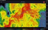
It's considering it VERY HARD as of latest scan.It's thinking about it. Angle has intensified for the past several scans.
View attachment 47544
Yeah, the Holly Bluff storm has the potential to make a one-and-done spinup. Even though it doesn't look particularly capable, sometimes line segments like these manage to produce very small and compact but nonetheless tornadogenic mesocyclones. Silver City's is more worrying in how large and well-established it is, but sometimes these little ones worry me more.The two best areas of tornado potential currently in Mississippi.

Yeah, I've seen this type of signature too many times in the same area and a lot of times, it ends in a QLCS spinupYeah, the Holly Bluff storm has the potential to make a one-and-done spinup. Even though it doesn't look particularly capable, sometimes line segments like these manage to produce very small and compact but nonetheless tornadogenic mesocyclones. Silver City's is more worrying in how large and well-established it is, but sometimes these little ones worry me more.
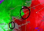
View attachment 47547
I'd probably put a warning on this. Two tight, little couplets, enough for at least a weak tornado to drop. Better safe then sorryMight be a tornado in-development over Holly Bluff.
View attachment 47548
Didn't even register for me until now, but Yazoo is in the path.I'd probably put a warning on this. Two tight, little couplets, enough for at least a weak tornado to drop. Better safe then sorry


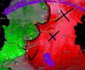
Inflow notch is visible, and this segment has jutted eastward by at least a few miles versus the rest of the line over just a few scans.Didn't even register for me until now, but Yazoo is in the path.
View attachment 47549

Night and shocker.. rain in IrelandGoing to call it a night soon for me, (3:30am here in Ireland, with strong wind gusts and rain in my area too, this week will be pretty horrific for rain and wind LOL) but will continue to monitor this embedded supercell for a brief tornado threat in the short term. Trying very hard
Story of our country but hopefully eying some exciting wind gusts. Tonight has been satisfying to watch unfold with the heavy rain. I'll hold on for a bit more before bed LOLNight and shocker.. rain in Ireland