The wide, broad-based nature of the trough, the wide nature of the warm sector, and the very westerly component of the deep-layer shear vectors atop what will likely be SSW to NNE oriented subtle confluence lines all really make it apparent why the specific two-word phrase used in the Day 3 outlook was put in there, regardless of who the forecaster was. Having said that, without a little more cyclonic curvature and height falls overtop the warm sector prior to the low-level jet lifting away, the number of deep, long-lived storms gets called into question. Also, with many of the convective allowing models hinting that this may not really get going until near or after sunset and near the Mississippi River or a hair west of there, even though that increases the potential for a nocturnal outbreak, it also increases the potential for the better instability and the stronger low-level flow to get a little out of phase with each other after a few hours into the event. The low-level jet and stronger low-level helicity want to start outpacing the instability after 03-06z Wednesday.
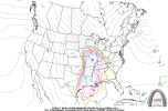
I very much see how this could end up as a tornado outbreak, or at least a case where we don't have a large number of supercells, but two or three tornadoes fully justify the use of that phrasing. Having said that, I also see how things could be just out of phase enough temporally to hold this back from its true potential. If the mid-level flow approaching the warm sector prior to sunset was a little more cyclonically curved, and if this wasn't a case where the mid 60 dewpoints are racing in 1-3 hours before go time and they were nearby during the morning instead, I'd be expecting this to be an eventual SPC High Risk event. My main area of concern is north central Mississippi back into southeast Arkansas and northeast Louisiana. I do think the greater tornado risk is focused south/east of about the whole northwestern half of the current Day 3 ENH Risk area from the Sunday outlook issuance. I think west and southern middle Tennessee and into west/northwest Alabama could be involved in a situation where tornadic supercells from the southwest are able to make it in before running out of the better low-level air mass, but how fast the 63+ dewpoints return during the evening and how much of the afternoon warmth we are able to retain overnight will dictate whether that is actually able to happen. Long-track supercells in events like this very often produce tornadoes farther east into more marginal low-level thermos than what models show and what meteorologists often think are possible. I'm just not fully sold on the idea of the better tornado risk getting east of U.S. 45 in northeast Mississippi or north of the Tennessee/Mississippi state line just yet. We'll see...
There is also the very real potential for a "sleeper" type tornadic supercell event during the afternoon and night across south Mississippi, southwest Alabama, and southeastern Louisiana. Several convection allowing models are indeed already picking up on this idea.